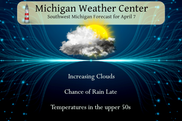
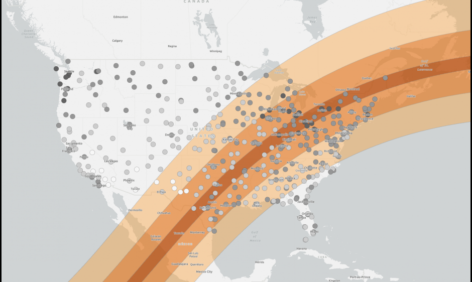
We will see more spring-like weather this week with temperatures rising to 60 to near 70°. Increasing clouds are in store for today with rain moving in later this afternoon through the overnight hours. Clouds should move out in time for tomorrow’s solar eclipse. The eclipse begins at 1:55 for our area with the time of maximum coverage at 3:10.
Eclipse
NWS Forecast
Weather History
1954: A tornado destroyed two barns and damaged a house and apartment building near Fulton in Kalamazoo County.
1982: Temperatures plunge to near zero as arctic high pressure persists over the Great Lakes states. Lansing falls to 2 below zero for a record low for the date and the latest sub-zero temperature on record. Muskegon falls to one degree above zero and Grand Rapids to 3 above for their coldest April temperatures on record.
On April 7, 2020, several clusters of severe thunderstorms tracked across the area including supercells, multicells, and bowing segments. The first area impacted stretched from the Tri-Cities southeast into southern portions of the Thumb. The second occurred mainly across a stretch that included Livingston, Washtenaw, Lenawee, Monroe, and portions of Wayne counties. Numerous reports of large hail were reported with these storms with golf ball-sized hail observed in Midland and Lapeer Counties.
On April 7, 1954, an F2 tornado hit Genesee County at 6:40 pm causing 2 injuries and $25,000 in damages.
1926: Lightning started a disastrous oil fire at San Luis Obispo, California, which lasted for five days, spread over 900 acres, and burned over six million barrels of oil. Flames reached 1000 feet, and the temperature of the fire was estimated at 2,500 degrees. The fire spawned thousands of whirlwinds with hundreds the size of small tornadoes. One vortex traveled one mile to the east-northeast of the blaze, destroying a small farmhouse and killing two people. Damage totaled $15 million.
1948: Six tornadoes ripped through Northern Illinois and Indiana; mainly across the southern and eastern suburbs of Chicago. The hardest hit was from a tornado that moved east from near Manteno, IL to near Hebron, Indiana. This storm left four people dead; three in Grant Park, IL, and one near Hebron, IN with 67 injuries and over a million dollars in damage. Other strong tornadoes in the area moved from near Coal City, IL to Braidwood, IL, and from Calumet City, IL into Indiana. Further south, two strong tornadoes occurred across the northern parts of Champaign and Vermilion Counties in Illinois.
1980: Severe thunderstorms spawned tornadoes that ripped through central Arkansas. The severe thunderstorms also produce high winds and baseball-sized hail. Five counties were declared disaster areas by President Carter. A tornado causing F3 damage also affected St. Louis and St. Charles counties in Missouri producing $2.5 million in damage. Click HERE for a radar video of the F2 tornado that cut a path from near Mayflower to the north of Beebe, Arkansas. The radar video is courtesy of the NWS Office in Little Rock, Arkansas.
2010: The record heat that affected the region on April 6-7 included 93 degrees at the Washington-Dulles Airport on April 6, the earliest 90-degree reading on record. On April 7, Newark, New Jersey, shattered its daily record by seven degrees when the maximum temperature rose to 92 degrees. The Northeast ended up with its second warmest April in 116 years.
Forecast Discussion
- Dry and breezy today, rain arrives this evening

Sunshine is expected for much of the day especially in areas farther
north and east, then cirrus and altostratus should move in during
the afternoon. East-southeast winds will become increasingly breezy.
Lowered the dew points against the NBM with expectation of quite a
bit of dry air mixing during at least the first half of the day.
Relative humidity dipping near to below 30 percent along with gusts
20-25 mph may result in increased potential for fires to spread out
of control during the afternoon, particularly in fields with fuels
(vegetation) that dry out quickly.

CVA in the mid-levels along with moisture arriving in the 5,000 to
10,000 ft layer should promote showers eventually overcoming the low-
level dry air during the evening. HREF mean precip amounts across
the area are in the ballpark of 0.05 to 0.15 inches, and max amounts
aren`t much more than 0.25.

- Warmer Monday and partly to mostly sunny for the eclipse

Monday afternoon is now in view of the HREF, and it`s fairly
encouraging regarding cloud cover during the partial solar eclipse
for Lower Michigan happening between roughly 2pm and 4pm. Diurnal
boundary layer mixing of low-level moisture may result in scattered
cumulus clouds for part of the day, and that appears to be the only
level of the atmosphere threatening to produce clouds. It should be
relatively drier with fewer clouds south of I-96. Temperatures will
be warmer, with highs in the 60s (possibly 70 in southern areas),
though cooler near Lake Michigan with south-southwest winds.

- Scattered showers Tuesday, mainly dry Wednesday

A cold front on Tuesday brings scattered showers and perhaps a few
tstms but guidance still differs on timing of the frontal passage
and the shower threat may be over by afternoon if the faster ECMWF
solution verifies. Models are now trending toward a mostly dry
Wednesday as that front slips south and east of the area and a sfc
high briefly settles in.

- Late week rain and wind, ending in time for the weekend

On Thursday a deepening low pressure system is progged to lift
northeast from the Gulf coast and track through the Ohio Valley
region. A large shield of rain on the north side of that low is
shown to overspread lwr MI on Wednesday night or Thursday as
northeast winds stiffen.

However ensemble QPF spread remains rather large owing to
differences in the sfc low track and timing, with a few members
suggesting up to 2" in a trowal-like feature and others showing less
than 0.25" due to a more eastern track of the low. So obviously fcst
confidence is still on the lower side with respect to rain
coverage and amounts on Thursday.

Regardless of the late week upper trough evolution and sfc low
track, there is relatively good ensemble agreement for a period of
windy conditions Friday with gusts up to 40 mph in the cold
advection pattern on the back side of the low.

There is also decent agreement that the deep upper trough lifts out
just in time for next weekend within a progressive pattern aloft.
Incoming/building upper ridge between the departing trough and the
next Plains upper low should lead to predominately dry weather with
moderating temperatures, although a few showers cannot be ruled out
next Sunday in strong warm advection pattern.
60 and lots of sun today. It was nice to be able to have the windows open this afternoon.
The chances of having favorable skies for the eclipse tomorrow are looking pretty good.
I’m off to Ohio. Hope everyone gets a chance to view the eclipse wherever you may be!
The overnight low here in MBY was 29 at this time it is clear and 41. We will be heading out for Ohio around noon. The weather at my picked out site is sill kind of up in the air with rain overnight and hopefully clearing before the eclipse.
Slim
The official H/L yesterday at Grand Rapids was 59/31 there was no rain/snow. The sun was out 100% of the time. The average wind speed was just 4.1 MPH For today the average H/L is 54/34 the record high of 81 was set in 1991 the record low of 3 was set in 1982. The most snow fall of 5” fell in 1956. The most snow on the ground was 7” in 1982 Last year the H/L was 50/30.
Slim
There is a very small chance that GR hits 70 degrees tomorrow, but after that no 70’s in sight for weeks on end, despite the constant hype! WOW!
The average high right now is only 54. +16 doesn’t happen everyday.
Who would have thought?
All the hype on how warm it was yesterday – it ended up one degree above normal! The low wind speeds and sun made it feel a little warmer. I see in WOOD’s forecast they show 3 days with high temps only in the 50’s, despite the constant hype! Incredible!
Yesterday was perfect. I see WOOD raised their temps. Near 70 degrees now this week! April will soon be warmer than average. The warmth just won’t stop.