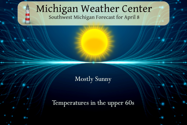
It looks to be a great day for the eclipse which occurs between 2 and 4 PM. Breezy southwest winds will push temperatures to near 70 degrees inland from Lake Michigan.
Mostly sunny skies are likely Monday afternoon for the eclipse. Some limited impacts to viewing are possible from high clouds but these clouds are usually semi-transparent. Don’t forget to wear eclipse glasses for safe direct viewing!
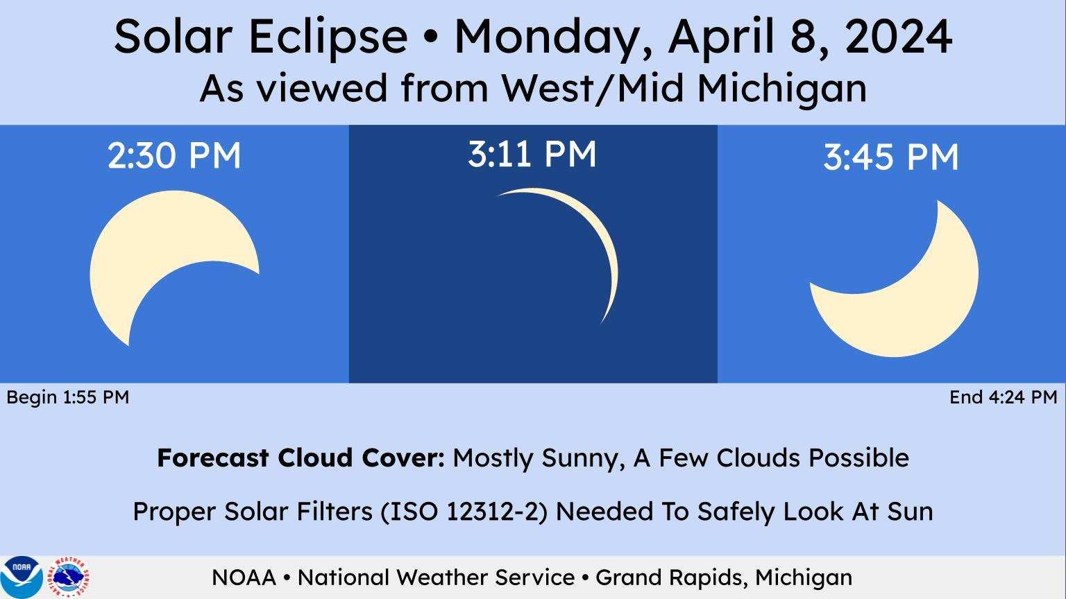
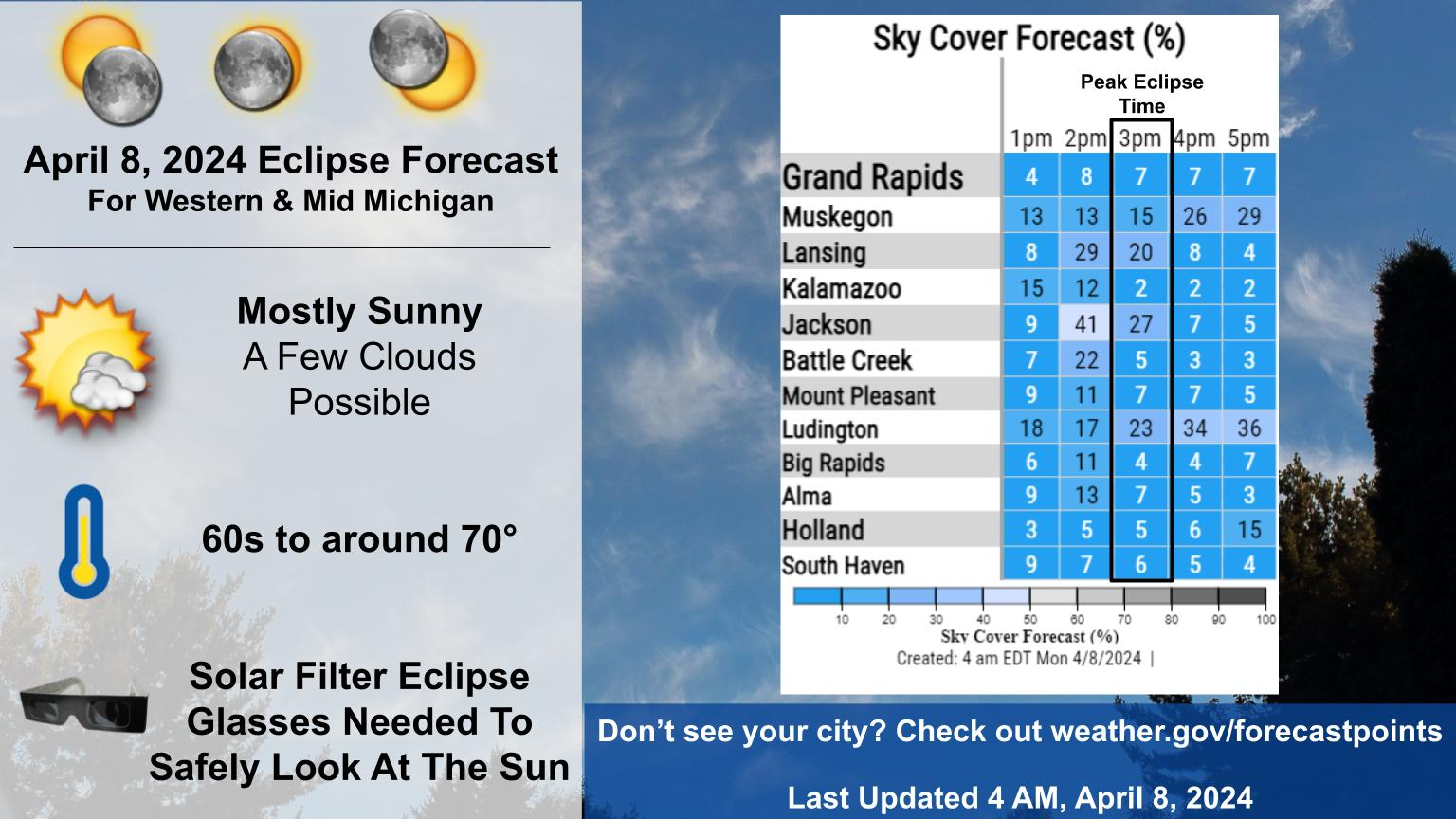
This is shaping up to be Lower Michigan’s best solar eclipse since 1994. If you are staying put in Western or Mid Michigan (plenty of valid reasons to do so), the cloud forecast has trended more optimistic. There are plenty of ways to enjoy the show as about 95% of the sun’s diameter gets blocked by the moon. You might be able to notice a slight dimming of the world around you. Take a look around and observe the strange shadows. Eclipse glasses with proper solar filters (ISO 12312-2) absolutely must be worn to look directly at the sun. It will be a warm and breezy day, but we think a temporary 2 to 4 degree temperature drop and a slight decrease in wind gusts is possible around the 3 PM hour as the eclipse reaches its peak.
NWS Forecast
Weather History
1938: A snowstorm drops several inches of snow across southern Lower Michigan. Lansing sets a record for the day with 5.1 inches and Grand Rapids with 4.3 inches.
1947: Three to five inches of rain and warmer temperatures combine with melting snowpack and partially frozen ground to cause some disastrous flooding along the Grand and Kalamazoo Rivers. Millions of dollars of damage occur as large sections of Grand Rapids, including the Comstock Park area, are under several feet of water.
2016: A spring snowstorm drops 4 to 6 inches of snow from Grand Rapids to Lansing. A total of close to 10 inches of snow fell at Grand Rapids during a wintry first week of April.
On April 8, 1980, Wayne County was hit by an F1 tornado at 7:15 PM.
On a temperature note, a high of 79 on this date in 2001 broke a 130-year-old high temperature record /76-1871/.
1938: Snow began to fall over central Oklahoma during the previous evening and continued to this day. In Oklahoma City, several snowfall records for the month soon fell to the storm, including the record for most total snowfall during April. The Oklahoma City snowfall totals of 0.8 inches on the 7th and 3.3 inches on the 8th remain daily records. In fact, the 3.3 inches of snow on the 8th is the most ever to fall on any single April day. The 4.1 inch total for the month is still the largest April monthly snowfall total.
1973: The state of Iowa and southwest Wisconsin saw severe blizzard conditions from April 8 through the 10th. Sustained wind of 40 to 50 mph, with gusts to 65 mph was reported with falling snow. Highways were closed, travel was suspended, and properties were damaged. Livestock and turkey losses approximated 20 million dollars. Record snowfall was reported in several localities. Belle Plaine had 20.3 inches; Dubuque had 19.2 inches, and Grundy Center saw 19 inches. Snow drifted as high as 16 feet. In southwest Wisconsin, this storm was quoted as being the “worst since 1921.”
1989: Two dozen cities in the southwestern U.S. reported new record high temperatures for the date. Phoenix AZ equaled their record for April of 104 degrees established just the previous day.
1998: A major F5 tornado struck western Jefferson County in Alabama leveling the communities of Oak Grove, Rock Creek, Edgewater, McDonald’s Chapel, Sylvan Springs, and Pratt City. The tornado lifted just two miles from downtown Birmingham. The twister had a track of 20 miles with the damage path averaging between ½ and ¾ of a mile in width. 34 people were killed, 221 injured and 1,000 homes destroyed.
Forecast Discussion
- Good weather in much of Lower Michigan for today`s eclipse

The forecast keeps trending in the right direction regarding cloud
cover for our area for what should be the best solar eclipse viewed
locally since May 10, 1994. The dry slot of the occluded upper
Midwest cyclone is working its way in early this morning. Remnant
moisture in the low levels may initially redevelop or maintain
scattered cumulus as boundary layer mixing occurs this morning,
until drier air mixes down. The HREF mean cloud cover is less
than yesterday`s guidance. Only minor concerns for clouds include
some cirrus intruding into southern Michigan (possibly thin and
not enough to obscure the sun), a few low-level cumulus hanging on
in interior central Michigan, and possibly some low-to-mid-level
clouds sneaking into the lakeshore vicinity north of Muskegon.

The HRRR appears to be modeling the reduction in insolation from the
eclipse, and dips our temperatures about 2 to 4 degrees lower around
the eclipse`s peak, which is shortly after 3 PM (19 UTC). It also
suggests a temporary loss of the superadiabatic lapse in the near-
surface layer which may decrease the wind gust potential slightly.
It will nonetheless be a fairly breezy and warm day with winds
becoming southwest.

- Passing shower or slight chance thunderstorm Tuesday

There is a chance of showers around daybreak Tuesday with a cold
front passing through during the day, which will turn our winds
westerly. Afternoon redevelopment or strengthening of showers or
thunderstorms is not favored west of US-127 and there`s only a
slight chance near US-127.

- Wet Wednesday night and Thursday, windy and cool Friday

Medium range models/ensembles are coming into better agreement
regarding the wave ejecting northeast from the Gulf coast and
through the Ohio Valley on Thursday. The most likely scenario at
this time is for a deepening sfc low to track along the frontal
boundary and pass near Detroit/Toledo 00Z Friday, sending a
widespread area of rain with embedded thunder into lwr MI for late
Wed night and Thursday.

More than half of the ECMWF ENS members are producing rainfall
amounts in excess of one inch and there`s even support for up to two
inches from a few members so this system looks like a soaker for
our area.

There continues to be great ensemble agreement for rather windy
conditions occurring Friday on the back side of the sfc low with
most members indicating gusts in the 40-50 mph range out of the
northwest. Lingering clouds and showers in cyclonic/cold advection
pattern could potentially hold temps in the 40s much of the day.

- Moderating temps next weekend, chance of showers Sunday

Height rises occur next weekend after Friday`s upper trough lifts
out, and H8 temps recover to near 10C. Highs near 70 may be in reach
by Sunday. However the latest guidance is less bullish on degree of
ridging aloft and warm advection return, keeping the upper ridge
axis to our west. Northwest flow aloft could support some showers
rolling through on Sunday and may also suppress the better warmth to
our west and south early next week. Temperature spread next Mon-Tue
is rather large at this time.
Beautiful day and wonderful eclipse experience!! We stayed here but enjoyed it. I was able to get a couple rough pix by putting glasses up to my phone.
Hope everyone got a chance to see it.
Same. Our pics didn’t turn out great, but pretty good. We sat outside for nearly one hour enjoying the show and the fantastic weather. Can’t ask for a nicer day for this event.
Yes… same a few pix… had to really use the crop tool. Lol
At this time the sky is clear with nice blue skies. Hope it stays this way. Here in the town of Bucyrus the main street dose not seem to have much traffic at this time. There is a park with some set up for the event but we are going to just stay here at the motel. Right out the door here the time of totality will be 3 minutes 49 seconds. At a very small town to the west of here where the center line runs thru the time there is just 7 seconds longer. We drove thru that… Read more »
Enjoy the eclipse today everyone! Not very often we get to experience an event like this, especially in Michigan with clear skies in April
Not to mention temps in the low 70s. It going to be a fantastic day!
We just got in from a walk. I said, “Could the skies be any bluer today for the eclipse?” It is going to be GREAT!!!
Agreed! Not a cloud in the sky. Let’s hope it continues this afternoon.
We are ready. We are making some cupcakes today. We have our glasses ready (bought them from Amazon weeks ago…same ones a local eye Dr was selling too). We will be closing our curtains to help protect our dog’s eyes.
Have a great day!!!
We like chocolate cupcakes at the Weather Center 🙂
Awe shucks… these are homemade vanilla with yellow frosting and and oreo (as the moon)!! About to go frost!!!
Good morning from Bucyrus Ohio. At the current time here it is partly cloudy. The forecast for today is partly ot mostly sunny with highs in the low 70’s with falling temperatures during the eclipse. We are going to stay right here in the motel paring lot area there is a lot of grass areas here and several other guest have lawn chairs (we do too) and will just see the eclipse from here.
Slim
Slim,
Can’t wait to hear about your trip!! Stay safe!!!
Hope you get some good photos. If you do, please share them. Enjoy the show, my friend!