Yesterday we had a low of -7.6° and the high was 9.5° with a few light snow showers. The lake effect snow machine will continue today with some light accumulations along and west of Highway 131. An inch or so of new snow is expected today towards the lake. Highs will only top out in the 5 to 15 above range. A brisk west wind of 15 to 25 mph will drive wind chill values to 5 to 15 below. Roads will remain slick with road temperatures well below freezing.
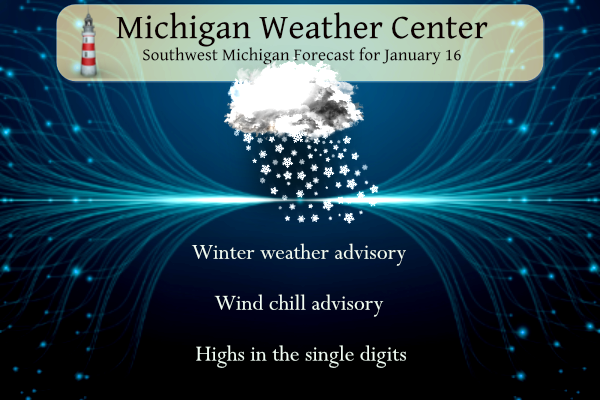
Winter Weather Advisory
...WINTER WEATHER ADVISORY REMAINS IN EFFECT UNTIL 1 PM EST THIS
AFTERNOON...

* WHAT...Lake effect snow. Additional snow accumulations of up
  to one inch.

* WHERE...Oceana, Muskegon, Ottawa and Allegan counties.

* WHEN...Until 1 PM EST this afternoon.
Wind Chill Advisory
...WIND CHILL ADVISORY REMAINS IN EFFECT UNTIL 10 AM EST
WEDNESDAY...

* WHAT...Very cold wind chills. Wind chills as low as 20 below
  zero.

* WHERE...Eaton, Ingham, Kalamazoo, Calhoun and Jackson counties.

* WHEN...Until 10 AM EST Wednesday.

* IMPACTS...The cold wind chills could cause frostbite on
  exposed skin in as little as 30 minutes.
Forecast
Weather History
1949: Temperatures reach record highs in the mid to upper 50s for the second consecutive day across southwest Lower Michigan.
1972: The arctic air holds on for one more morning of record lows as Grand Rapids falls to 16 below zero and Muskegon tumbles to 11 below.
On January 16, 2009, the region was in the middle of a five-day arctic outbreak. Detroit set a record reaching -15 degrees. Flint was as low as -10, while Saginaw was -6.
U.S.A and Global Events for January 16th:
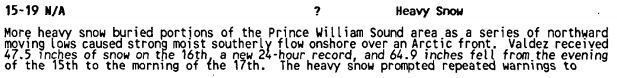
1990: Heavy snow fell across Prince Williams Sound and the Susitna Valley of southern Alaska. Valdez was buried under 64.9 inches of snow in less than two days, including a record of 47.5 inches in 24 hours. The heavy snow blocked roads, closed schools, and sunk six vessels in the Valdez harbor under the heavy snow’s weight. The image below is from Storm Data.
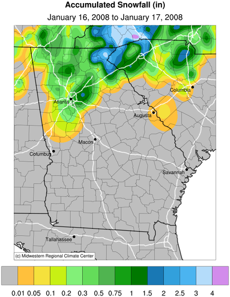
2008: An area of low pressure brought snow, sleet, and freezing rain across northern Georgia. Three to four inches was a typical amount reported from many of the northeast Georgia counties. Click HERE for more information from the NWS Office in Atlanta, Georgia.
Forecast Discussion
- Lake Effect snow continues into this afternoon -

 Lake effect snow bands will continue to stream through the region
today into this afternoon. While snow bands have diminished there
remains constant lake effect along the lakeshore with reduced
visibilities at Holland north to Muskegon. Given the air
temperatures and the persistent flow through this timeframe, have
kept the advisory.

- Wind Chill Advisory Today into Tomorrow -

The big question through this timeframe is whether or not to drop,
expand or do nothing for the wind chill advisory. Looking at
Bufkit soundings, winds will mix down with gusty winds this
afternoon into tonight. In areas outside the lake effect region,
the skies will start to clear this evening. That will help
radiational cooling which will allow temps to drop which coupled
with the strong southeast winds will allow for wind chills to be
-15 to -20 tonight into Wednesday. due to the influx of wind have
 expanded the Wind chill advisory to include Barry and Clinton
 counties. Areas outside of these regions should remain cloudy
 enough and in the lake effect regime to not get cold enough.

Wednesday will warm up with just enough warm air advection to get
daytime high into the teens.

- Winter hangs on through the end of the week

850mb temperatures will remain cold right into Saturday...ranging
from -13C to -19C during the Wednesday night through Saturday time
frame. When combined with +5C water temperatures delta t`s will
range from 18C to 24C. Plenty of instability will be in place given
about 13C kicks in the lake effect snow process. The other portions
of the equation with lake snow beyond instability are moisture and
lift. We have solid moisture in place from Wednesday night through
Saturday with the GFS indicating greater than 70% RH in the 1000-
700mb range through the period. In terms of lift we have upper
shortwave troughs moving through on Thursday and and again Friday
night. Bottom line, lake effect snow will not shut down and will
continue from Wednesday night all the way through Saturday. It will
not be until Sunday when we warm enough to take lake effect snow out
of play.

Wednesday night and Thursday a weak westerly flow will be present so
areas west of Highway 131 will be favored for lake effect snow.
Thursday night through Friday night the flow will shift northerly
behind Thursday`s shortwave so the lakeshore counties will be the
locations that see the snow. The winds go back to westerly on
Saturday but the flow remains weak so the lakeshore remains the
place that will see the snow. In terms of amounts, nothing looks
heavy from Wednesday night through Saturday. The time frame that may
stand the best chances for several inches of accumulations looks to
be Thursday night and Friday with a longer north fetch and what
looks to be a Lake Superior connection.

- Warmer for Sunday and Monday

After what will be a week or so of below freezing temperatures we
"warm" back towards normal beginning on Sunday and especially into
Monday when 850mb temperatures moderate back to near Zero C. We
should see highs on back to around the freezing mark on Monday and
above freezing by Tuesday.

Models bring rain back into the area especially into next Tuesday on
the backside of a departing surface high. With above freezing
temperatures and rain we will start to melt some snow.
How’s the rivers looking near some of you? Chucked full of ice? Open flow?
In downtown Portland there is lots of river ice build up. While I am no river ice expert I am wondering if we may be in the early stages of an ice jam forming. After all we have had that happen here before.
>>>>>>Breaking Winter Weather Alert>>>>>> plenty of SNOWSTORMS showing up in the next 2 weeks. Some people don’t realize you can get big snowstorms this time of year with above normal temps! Case in point – remember last winter? Incredible!
https://www.pivotalweather.com/model.php?p=snku_acc-imp&rh=2024011618&fh=336
Let me describe the new CPC model that I came across while surfing the internet today! It is: spectacular, beautiful, gorgeous, breathtaking, amazing, incredible, serene, unbelievable, rad, fantastic, and WOW! WOW! WOWEE!
DDDD DDDDDD DDDDD……BLOWTORCH ALERT……GET PREPARED NOW!!! Very high probability of extreme melting and flooding early next week through the end of the month!
https://www.cpc.ncep.noaa.gov/
Today’s CPC is an absolute blowtorch for the next 2 weeks! I love one week winters!
Just put out the alert!!! LETS GOOOOO!!
So after a very short cold snap it’s back the normal well above temp pattern!
I can’t get over what a great stretch of winter weather we are having! Also, almost up to 30 inches of snow already, with plenty more yet to come! Some people said winter would be cancelled and others said we might get 30 to 40 inches of snow all season! The delusions and denials get worse every year!
What a day for snowshoeing! Simply fantastic out there! The wind was a little colder than yesterday, but with a face mask it was very comfortable! Almost got too hot again, yet some people say hibernate and stay indoors! Pathetic!
Hey Mookie, hilarious that Kirkwood is trying to shoehorn in a high of 26 with a low of 6 next week Wednesday. Looks like classic wishcasting after seeing what the CPC said yesterday and the weather channel today has a high of 40 and a low of 36 for that same day. We’ll have to come back to this to see how it plays out.
Mark it down – probably way off! Good catch. They always do that at WOOD.
Haha Mookie, must be Chief Ellen shut down Kirkwood!! The new temps in the graphic above are now 38 on next Wednesday with a morning low of 32!!
That is definitely off. All the models have it above freezing
For sure Mookie and Nathan! This is a good one to track!
Good news, we are basically at the coldest average temperatures of the year. We only drop a few tenths of a degree before plateauing and slowly ascending
That must have been a crazy winter MV! I knew Maine was cold and snowy but did know they could get over 300 inches! Wow.
Got lots of great pictures this morning. Landscape is breath taking with all this snow. Nothing better than the great outdoors!
Winter weather Advisory extended till tomorrow I see we are getting the sun out up here in Boyne it’s cold but beautiful here ….INDY
Enjoy INDY! It is very nice up there.
Oh yeah, there’s another reason why I don’t go out in this ridiculous cold, I HAVE A JOB! But cold and winter suck as well, so that’s another reason too! I know Slim and Michael are retired and they did their time in long careers, but everyone else???
I try to not spend too much time outside when it is cold. I walk almost every day and this winter I was able to walk outside until just this week. I walk outside in the summer no matter how hot it is. In the winter I use the treadmill when there is a snow on the road. I am retired but I still work part time.
Slim
Yep, my day does the same Slim, retired but still does part time stuff here and there when he feels like it. Mom and dad also stay very active in their 70’s so that’s a good thing too!
Should say my dad does the same
My parents are also very active in their upper 60s. To me age doesn’t really matter. I know 30-40 year olds who are in terrible shape and 70 year olds who are in great shape. Just gotta stay active, happy, and eat healthy!
Ski resorts from Vancouver to Montana to Maine have been closed because it’s too cold to ski. In Northern Michigan, it looks to be very little skiers at this time. Boyne Highlands is practically deserted.
I’m at Boyne right now plenty of snow on the hills not sure what you mean by practically deserted that’s false….INDY
You can check the Boyne Highlands webcams for yourself. There was no one at the main chair – usually a 5-15 minute wait anytime I’ve gone. Brrrr
Heading out for a snowshoe hike! Later people! Rock n roll will never die!
Virtually no schools in Kent County are closed today and the wind chill only about -8 degrees! Not bad at all! Dress for the weather and enjoy!!!
I see some the warm weather fanatics at still at it! Telling people it is too cold to go outside! Give me a break! We are having a great winter week! Get outside and enjoy it!!
The official H/L yesterday at Grand Rapids was 10/-5 The high of 10 was the coldest since January 2019 when highs of +2 and +4 were recorded on January 30th and 31st The low of -5 was the 1st time below 0 since -2 in 2022 and the coldest low since -12 on February 17 2021. For today the average H/L is 31/18 the record high of 58 was set in 1958 and the record low of -16 was set in 1972 and 1996. The most snowfall of 5.5” fell in 1924 and the most snow on the ground was… Read more »
Rocky, you’re spot on. I’m out taking pictures this morning. Stunning landscape. I have made in Canada gear designed for Arctic cold! You don’t have to stay inside looking out the window complaining! I enjoy all types of weather even if it’s not to my liking. Incredible!
I would venture 90% of the population or more is heeding the NWS’s advice and staying inside on these bitterly cold days. Let’s not act like everyone is outside enjoying below zero wind chills. Unless you have on a full ski mask, any exposed skin can get frostbit in 30 mins or less. Nothing to mess with.
I go out in a balaclava, -80 degree rated arctic snow boots, leather insulated gloves, Carhartt insulated coat with hood and insulated jeans – seems to do the trick. When I lived in Maine we would sometimes have to wear a snowmobile suit with an insulated coat on top, scarf and goggles. It got so cold your eyeballs would freeze. The winter of 72/73 was brutal out there with temps 40 to 50 below zero. That season we had over 300 inches of snow.
Good stuff!
Excellent!
So cold today that more schools were closed. Who would want this? The good news is that the blowtorch is on starting next week with melting snow. If I had to guess, the big winter event of 2024 is already behind us.
Let me describe the scenery in the woods yesterday while I was cross country skiing! It was: spectacular, beautiful, gorgeous, breathtaking, amazing, incredible, serene, unbelievable, rad, fantastic, and WOW! WOW! WOWEE! I will never understand why people do not dress for the cold and go enjoy nature! Instead they complain about winter and cold weather? Take up a winter sport!
Breaking News….it was not cold, if properly dressed, in fact I got too warm and needed to take a layer off! Rock n roll people and enjoy this spectacular stretch of near perfect winter weather!!!!!!!!!!
A chance for snow lovers like me to get out and enjoy the winter weather before “spring” weather next week melts it all,,,
Hooray, today is the midway point of meteorological winter. Man, time flies. A few more days until we revert back to more seasonable, mild temps. From this morning’s forecast discussion:
“We should see highs on back to around the freezing mark on Monday and above freezing by Tuesday. Models bring rain back into the area especially into next Tuesday on the backside of a departing surface high. With above freezing temperatures and rain we will start to melt some snow.”
My daughter’s classes canceled today at MSU do the cold I thought of you Mark …INDY
Our daughter is in school west of Chicago. Even colder there but class was not canceled. But, her school is a fraction of the size of MSU.
When I was in college many years ago… I only remember aboout a handful of closures during my time there. It was mainly due to the cold… since most walk to classes.
We had classes closed in the 2019 vortex and March 2020