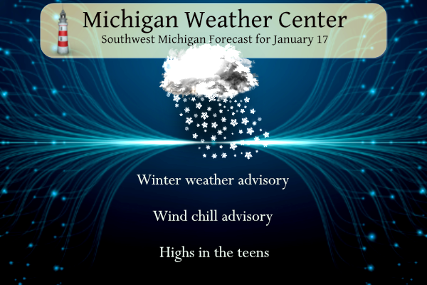
After struggling with temperatures in the single digits and windchills in the negative digits we will see a warmup today into the teens. Yesterday started with a morning low of 2° and we had a brief period of a high of 10° with a few glimpses of sun. Our current winter weather advisory expires at 11 am. Next week we are still on track for above-freezing temperatures.
Forecast
Weather History
1952: Temperatures rise to record highs of 61 degrees at Battle Creek, 59 degrees at Lansing, and 56 at Grand Rapids.
1982: For the second time in a week, extremely cold arctic air drops temperatures to record low levels. The low of 9 below zero at Muskegon is followed by an afternoon high of 7 above. It is even colder away from Lake Michigan where high temperatures remain below zero during the day. Lansing has a high of 1 below and Battle Creek maxes out at 3 below.
On January 17, 2009, snow overspread southeast Michigan around 10 a.m. and continued into the night. Twenty-one-hour snowfall totals averaged 4 to 7 inches along and north of I-94 with a few isolated 8-inch reports north of I-69. A low-pressure system tracking from Wisconsin eastward across Mid-Michigan was responsible for the snow. Some of the higher snowfall totals included Auburn (Bay County) 8.0 inches, Pontiac (Oakland) 7.2 inches, and Fairgrove (Tuscola) 8.0 inches.
Also on January 17, 2004, the city of Sebewaing in Huron County received 6.0 inches of snow from a passing snowstorm.
U.S.A and Global Events for January 17th:
1490: On the night of January 17 through the 18th, a “certain fine rain, which froze whilst it fell, and make icicles upon trees” occurred in Florence, Italy. “There was such a quantity of it that the weight bowed the trees down to the ground and broke the branches.” The above is from “A Florentine Diary from 1450 to 1516” by Landucci, Luca. Click HERE to read the book.
1837: The green flash was first documented by Captain Back of the H. M. S. Terror while in the Arctic during 1836-1837. He wrote: “In the morning, however, at a quarter before ten o’clock while standing on an ice hummock about 17 feet high, and looking toward the east, I had observed the upper limb of the sun, as it filled a triangular cleft on the ridge of the headland, of the most brilliant emerald color, a phenomenon which I had not witnessed before in these regions.” Click HERE for more information about green flashes from EarthSky.org.
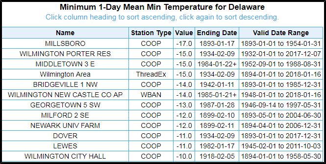
1893: Delaware’s coldest temperature of -17 F occurred on January 17th, 1893, in Millsboro.
1916: Reno, Nevada, received 22.5 inches of snow, its greatest 1-day snowfall total ever. Click HERE for more information from the Reno Gazette-Journal.
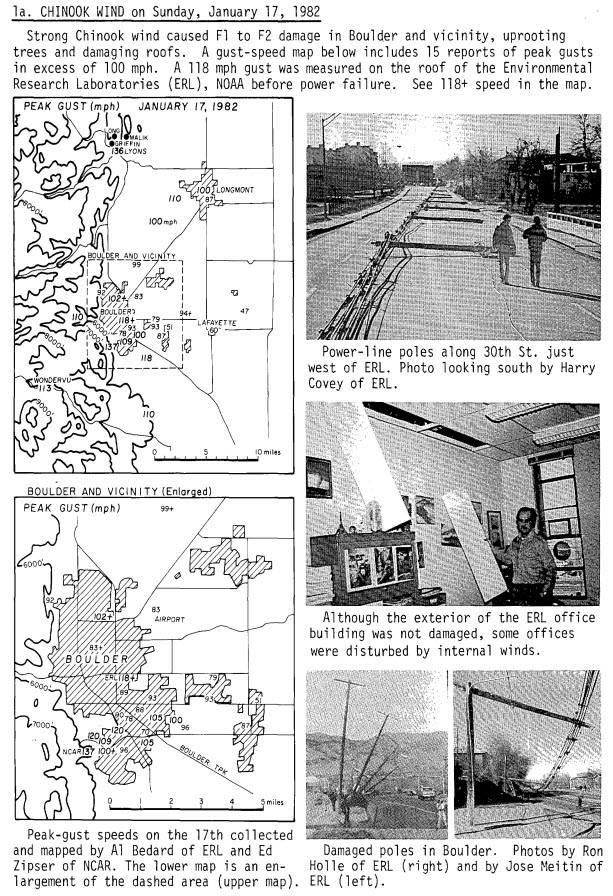
1982: Strong chinook winds caused severe wind damage in Boulder, Colorado. A wind gust of 118 mph was recorded on the roof of the Environmental Research Laboratories (ERL), and a wind gust of 137 mph was measured atop the roof of the NCAR building (in the southwest part of the city, 600 feet above ground level). The high winds uprooted trees and damaged roofs.
1994: On January 17, 1994, at 4:31 a.m. PST, a magnitude 6.7 earthquake centered in Northridge struck the southern California area. Known as the Northridge Earthquake, it caused at least 57 fatalities (a subsequent study put the death toll at 72, including heart attacks) and injured thousands. Click HERE for more information from the California Department of Conservation.
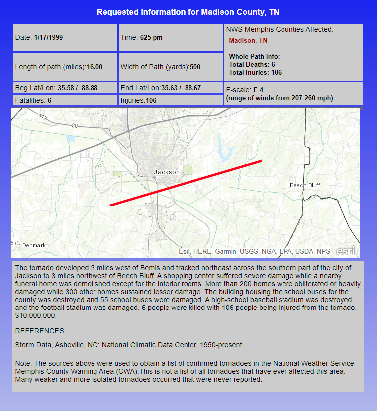
1999: An F4 tornado tracked across southern Jacksonville, Tennessee, damaging more than 200 homes and 55 buses. The storm killed six people and injured 106.
2016: A potent storm system developed and tracked quickly eastward across the Gulf of Mexico and toward Florida on Saturday, January 16, 2016. The impacts from this storm reached west-central and southwest Florida during the early morning hours of Sunday, January 17, 2016. A squall line of strong to severe thunderstorms, just ahead of the cold front, produced periodic wind damage and isolated tornadoes as it quickly moved ashore across west-central and southwest Florida and pushed across the state. Two EF2 tornadoes touched down, one near Siesta Key in Sarasota County and the other near Duette in Manatee County. Two adults were killed and four others injured when their mobile home rolled over and was destroyed by the tornado in Manatee County. Click HERE for more information from the NWS Office in Tampa Bay, Florida.
Forecast Discussion
- Lake Effect Snow with cold temps continue today -

Latest Radar continues to show lake effect bands streaming
from the strong gusty westerly flow this morning. The Lake
remains warm and couple that with the mixing from aloft and you
get strong flow that will have snow and blowing snow that will
reduce visibilities and allow for difficult travel this
morning. That wind has been the driver for the wind chill
advisories south of I 96 and East of US 127. Those conditions
will continue through this morning before temperatures warm
enough for those conditions to subside. The winds will remain
gusty through the daytime before the gradient slackens enough
and the inversion build in tonight for the winds to weaken this
evening.

- Snow and Cold continues into Saturday

Winter weather will continue right through the remainder of the
work week with snow and cold both staying in the forecast. It
is not really until we get out into Saturday night that we warm
enough in the lower troposphere to end this episode of lake
effect snow. So, the lake effect snow machine will run unabated
into Saturday at least.

Zonal flow will dominate the pattern Thursday with a ribbon of
mid level moisture that should bring snow showers south of I-96.
This synoptic type snow will be in conjunction with the lake
effect occuring. So a lake enhanced synoptic snow will engulf
the southern portion of lower Michigan. An additional 1 to 3
inches is possible with the heaviest snow along the lakeshore in
Van Buren county. However given the variability in the
position of the mid level moisture this is subject to change.

We will see a shortwave slide in from the west Thursday night
and produce a light synoptic snow for areas near and south of
I-96. Lake effect will be most prevalent near Big and Little
Sable Points in a northerly flow. Both lake effect and synoptic
snow will continue into Friday with amounts generally on the
light side, 2 inches or less. Friday night into Saturday we
transition more into only lake effect in a north- northwest
flow. All of the snow in the Thursday night through Saturday
time frame looks to be light, but it will continue to produce
travel problems given cold temperatures, sub freezing road
temperatures and a constant source of ice (in the form of snow).

Temperatures from Thursday night through Saturday will remain on the
cold side of normal with lows in the single digits and teens and
highs in the teens and 20s. Normal highs this time of year should be
up around 30.

- Warmer weather and rain in the forecast for early next week

850mb temperatures from today through Saturday are generally in the
-15C to -20C range. Those temperatures rise above the lake effect
snow threshold of -8C (given a current lake temperatures of +5C) on
Sunday morning. We are up around zero C at 850mb on Monday and
Tuesday which will produce high temperatures in the 30s to around 40
degrees. After single digit highs and wind chills much colder than
that, early next week will feel warm. An upper shortwave trough
moving through the area around the Tuesday time frame and a surface
boundary to focus on, precipitation will transition from rain/snow
to all rain into Tuesday. A melting snowpack will begin during this
time frame that may lead to areas of fog.
Let it snow! Let it snow, let it snow!!!
https://www.pivotalweather.com/model.php?p=snku_acc-imp&rh=2024011718&fh=384
GFS is showing more blue then green now with next week’s systems could it be its turning more colder GREAT BALLS OF FIRE 🔥 INDY
NWS GR says 1-3” possible tonight and then 1-3” possible Thursday night! It’s almost like an assembly line of snow. It just keeps comin!
You know it and some are still in denial! What a great stretch of weather! Keep it coming!
Don’t believe the propaganda the cold weather crazies are trying to spew. Warm temps are back through the end of the month starting Monday!
Great news>>>>>no blow torch next week! Just a minor warm up and then the following week right back to normal temps with snow! I love cold and snow!
The snow just keeps coming! This has to be one of the best stretches of winter weather in a while!! GREAT NEWS – perfect winter sports weekend! Get outside and enjoy!!! Wow, just wow, WOW!!!
Dumping snow right now at my house. Roads are only getting worse. My poor county must not have enough plows. Haha.
Ionia County Sherrifs office asked for travel on country roads to be avoided in Ionia County earlier today. Cars were getting stuck in snow drifts and the plows could not get through because of stuck vehicles. It’s a mess out there
Winter Storm Watch for far SW Michigan and NW Indiana for 6 + inches.
CPC showing major blowtorch impacts over the next 2 weeks starting Monday!! Get prepared now!!
Snowing for 6 days straight now should we call it a snow wave lol.. INDY
+1
Rock on!
We have really eaten away at our snow deficit! I thought spring was right around the corner? Anyone got any flowers blooming yet? What a joke!
Thay talk about Spring around the corner in mid December! Incredible!
Current conditions in Boyne Mountain SNOW its a beautiful thing …. Let it snow let it snow let it snow..INDY
As expected, I see WOOD raised their temps next Wednesday from 26 degrees to 38 degrees. Good catch Andy! Kirkwood always does that wishcasting even when we know it’s terribly wrong. Can’t believe they get paid for those forecasts sometimes!
Lol…. Kirkwood is way more experienced then a bow torch!!! INDY
Yep, Kirkwood is the wishcast master!
Eeeeee…. After a one week cold snap, back to well above normal temps starting Monday! BIG MELT COMING PREPARE NOW!
Let it melt, let it melt!
GR is now over 30 inches of snow! incredible!
Who would have thought?
At least 3 people on this blog!
And still almost a foot below average. I love it!
And that deficit will be growing rapidly starting next week!
Great news! Excellent winter conditions will last all weekend and then after a brief mini warm up, all signs show a cool down by month end with tons more snow! I absolutely love it!
Eeeeeee….. another near perfect mid winter day! Day after day of great outdoor winter conditions and all weekend should be perfect! Get the skis and snowmobiles ready to rock! WOW!!!
The official H/L yesterday at Grand Rapids was 11/2 there was 1.2” of snowfall. At the airport they reported 12” on the ground. The highest wind speed was 33 MPH out of the W. There was a reported 18% of sunshine. Here in MBY I had 2.2” of new snowfall and I have 15” on the ground. For today the average H/L is 31/18 the record high of 56 was set in 1952 and the record low of -10 was set in 1976. The record snowfall of 4.7” was in 2009. Last year the H/l was 46/37.
Slim
The last few days have been colder at the airport then here in my yard. I had a low of 6 here overnight and at this time there is some clearing and a temperature of 10.
Slim
… Eeeeee Eeeee Blowtorch alert! …