Lions defeated the Los Angeles Rams 24-23 at Ford Field in Detroit, giving the franchise and its fans their first taste of playoff success since 1991. GO LIONS!
Our headlines today are the bitter cold air in place over the state. At midnight the temperature in Otsego dropped to -8°, we are currently at -4° at 6:30 am. Our high temperature is forecast to be 11° today.
With the exception of Florida, the Gulf states all have winter storm warnings and advisories today.
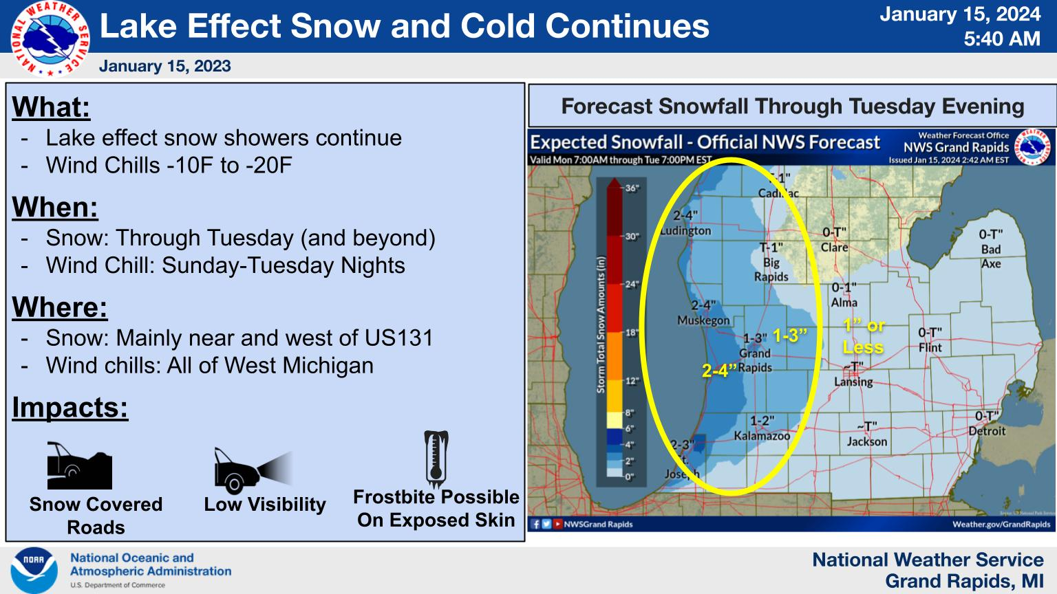
Lake effect snow showers will continue much of the week, with the greatest accumulations near and west of US131. Cold weather is expected with wind chills currently -10F to -30F and wind chills -10F to -20F Tuesday and Wednesday mornings.
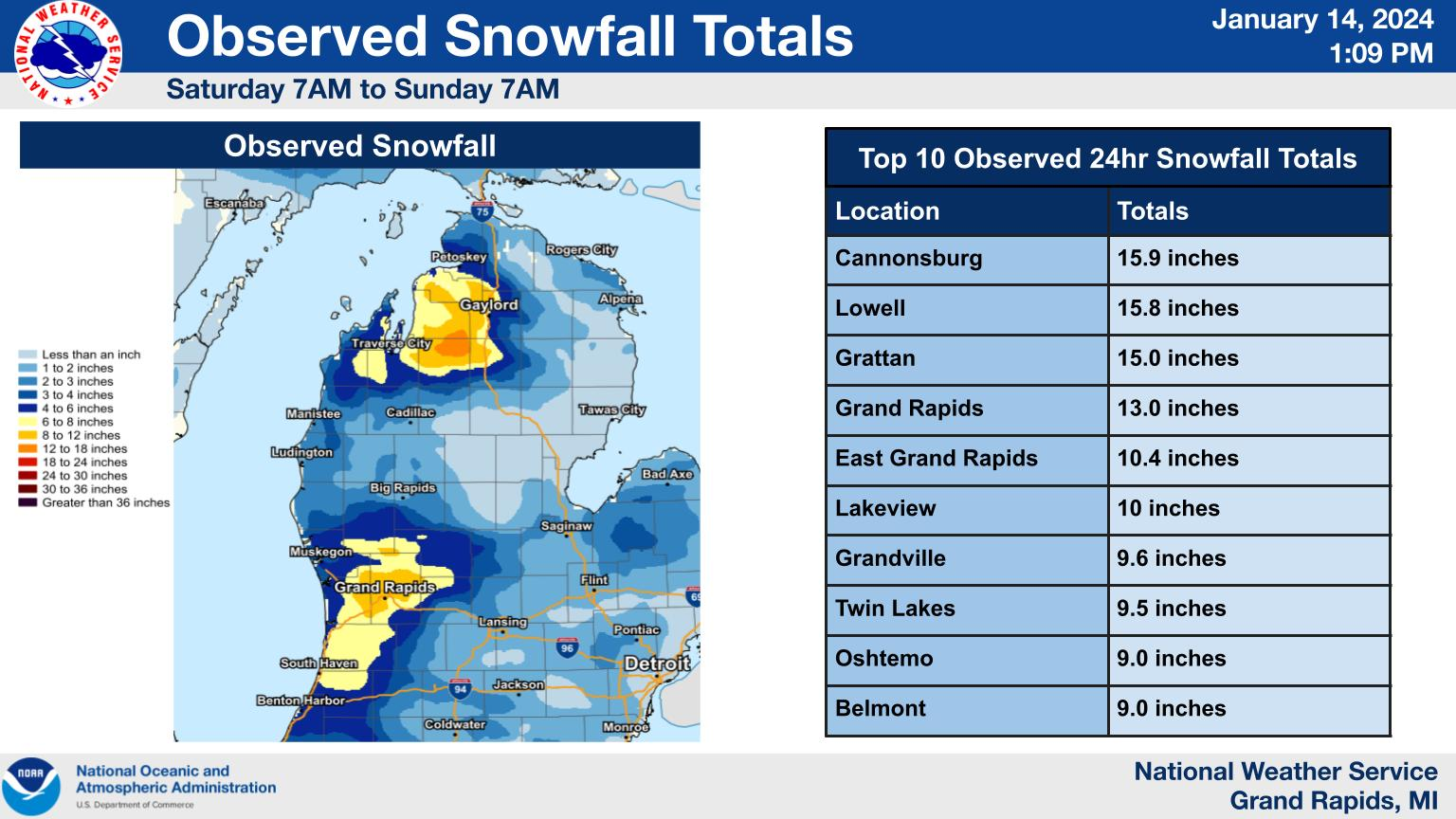
Here is the observed snowfall totals from Saturday 7am until Sunday 7am. The areas with the most observed snowfall fell under heavy bands of lake effect overnight and into this morning. This can be seen in the top 3 observed snowfall totals in the past 24 hours, with Cannonsburg, Lowell, and Grattan getting 15 or more inches.
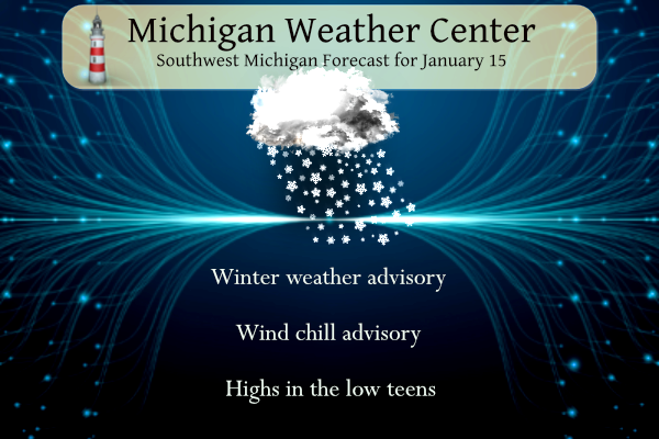
Advisories
...WIND CHILL ADVISORY IN EFFECT UNTIL NOON EST TODAY...
...WINTER WEATHER ADVISORY REMAINS IN EFFECT UNTIL 4 PM EST THIS
AFTERNOON...

* WHAT...For the Wind Chill Advisory, very cold wind chills. Wind
  chills as low as 20 below zero. For the Winter Weather Advisory,
  lake effect snow. Additional snow accumulations 1 to 3 inches.

* WHERE...Ottawa, Kent and Allegan counties.

* WHEN...For the Wind Chill Advisory, until noon EST today. For
  the Winter Weather Advisory, until 4 PM EST this afternoon.

* IMPACTS...Plan on slippery road conditions. The hazardous
  conditions could impact the morning commute. The cold wind
  chills could cause frostbite on exposed skin in as little as 30
  minutes.
Forecast
Weather History
1972: Muskegon falls to 12 below zero to set a record low. The temperature only rises to 4 below zero on this day, the coldest high temperature on record for the month of January at Muskegon. It is also the coldest high temperature for January at Grand Rapids, where the maximum is three below zero.
1984: Lansing plunges to 25 below zero and Grand Rapids falls to 14 below during a stretch of arctic cold. Temperatures are below zero for eight straight days at Lansing between the 14th and the 21st.
On January 15, 1972, the daytime temperature rose to only -3 degrees in Flint. This is the second coldest maximum temperature recorded in the city of Flint!
Also on January 15, 2007, an ice storm hit the greater Flint and Metro Detroit areas. Over 150,000 customers were without power due to the ice accumulations. The storm caused an estimated $2 million in damages. The same storm also left the Tri-Cities and Thumb regions with 4 to 6 inches of snow.
U.S.A and Global Events for January 15th:
1852: In 1852, the long, cold winter froze the Susquehanna River in Maryland to a depth of 2 to 3 feet, preventing all ferry service. Railroad officials overcame this perplexing situation by laying tracks across the ice, with trestles for either bank’s inclines. During the several weeks from January 15 to February 29, approximately 1,300 cars with a total weight of 10,000 tons were hauled across the river from Havre de Grace, Maryland, to Perryville, Maryland.
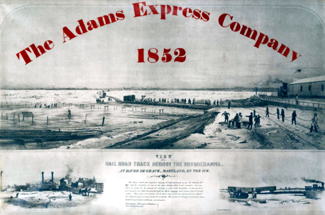
Railroad tracks on ice across the Susquehanna at Havre de Grace. Image Courtesy from Enoch Pratt Free Library.
1967: The Green Bay Packers beat the Kansas City Chiefs, 35-10, in Super Bowl I at the Memorial Coliseum in Los Angeles. From the weather station at the USC campus in downtown LA, the high temperature was 79 degrees, and the low was 51. There was a light west wind.
1972: In Flint, Michigan, the daytime temperature rose to only -3 degrees. This is the second coldest maximum temperature recorded in the city of Flint since 1921. Detroit’s high temperature was zero.
Forecast Discussion
- Lake Effect Snow Today and Wind Chills This Morning

There isn`t much change in the short term. Lake effect snow
continues to impact portions of the area with clouds firmly in the
dendritic growth zone and temperature differences between the lake
and 850mb around 20C with convergence along the lakeshore and
pushing northeast into the area as seen on SPC Mesoscale Analysis.
Not expecting much change with the orientation of convergence
throughout the day therefore felt confident to remove Barry and
Ionia counties from the Winter Weather Advisory. Light snow is
still possible in these counties, but accumulations will remain
more focused along the lake shore and into portions of Kent County
where an additional 1 to 3 inches of snow is possible through the
afternoon continuing slick conditions.

Wind chills this morning will be in the negative 15 to negative 30
range this morning along and south of a Grand Haven to Mount
Pleasant line. The coldest wind chills are expected across the
I-94 corridor with many reports in the negative 25 to negative 30
range. Wind chills are expected to rise mainly into the negative
single digits for the afternoon.

- Light Snow Along With Cold Wind Chills Tonight into Tuesday

A shortwave trough is expected to swing through the region late
tonight into early parts of Tuesday morning. There is some
associated mid to upper level moisture ahead of the trough which
could bring light snow to most of the area with amounts under an
inch. Lake effect will also be ongoing along the lakeshore where
amounts closer to an inch overnight are possible. Lake effect snow
will then continue throughout the day Tuesday with additional
light accumulations.

Wind chills again are expected to drop into the the negative 10 to
negative 20 degree range tonight and continuing through Tuesday
due to highs in the single digits above zero and breezy southwest
winds. Another advisory will likely be needed for portions of
western Michigan.

-Cold With Lake Effect Snow Through Saturday

Most of the long term period is dominated by persistent upper-level
troughing and associated cyclonic flow across southwest Michigan.
This pattern will keep lake effect snow showers in the forecast
through Saturday given 850 mb temperatures in the -14C to -20C
range. With lake temperatures of 5C to 7C, delta T values will be
around 20C to 27C providing environmental instability to support the
lake effect snow each day. There will be some enhancement to the
lake effect snow Tuesday Night/Wednesday and again Friday as
vorticity maxima rotate around the parent upper-level low. What will
make this different from earlier lake effect is weak low-level winds
which will keep most of the snow near and west of US 131. Sensibly,
this will translate to a few inches of lake effect snow west of
US131 with little accumulation east each day.

In addition, the arctic air mass across lower Michigan at present
remains in place through Saturday before we finally begin to warm.
Highs each day will generally be in the teens through Saturday with
overnight lows dependent on wind direction and Lake Michigan
influence. Our coldest overnight periods at this time look to be
Wednesday morning and Saturday Morning. Wednesday morning features
south and west of St Johns to South Haven, and across Central
Michigan, where lake influence is most limited. Saturday morning,
winds will be northerly with a reinforcing shot of arctic air
entering the area bringing cold temps areawide. These nights will
feature lows in the single digits above to single digits below zero.

-Temperatures begin to moderate Sunday

There is an end to the bitter cold in sight by Sunday as the upper-
level troughing dominating the forecast is replaced with shortwave
ridging. A warmer airmass allows highs to rise into the 20s while
surface and upper level ridging shuts off the lake effect snow
machine.
Today was 22 degrees below normal! WOW!
I was in GR today and witnessed people who still can’t grasp the concept of taking it slow! I was traveling M6 eastbound heading home and at Kalamazoo Avenue a F-150 truck spun out and hit the cement barrier causing another car to swerve to miss and fly into the ditch. Watched all that happen. A little further up I watched another truck fly into the ditch on the curve near the M-6/96 interchange. Slow and steady wins the race with the current conditions out there!
People need to slow down and stop tailgating! There are many horrible drivers when the roads are clear, let alone when there is snow and ice!
This an absolutely GREAT winter night of weather! I spent hours outside today and no it was not cold, if dressed properly! Who would have thought?
Not sure if anyone saw, but we have had cloudy or mostly cloudy skies every day for the past 30 days. Crazy!
About 14” of snow cover here, but it’s hard to measure with the drifting. My deck is pretty shielded from the wind so I think it’s pretty accurate
Sun has been MIA lately!
The sun has made an appearance here yesterday and today. We’re farther away from the lake of course, but it has been cloudy lately. Then again , it’s usually pretty cloudy in the winter.
Here’s the new map that goes through the end of January. Some people can’t deal with facts!
Wow! Blowtorch is back!
Yes it is!!
Wow the warm weather crazies are in bad mood, because that can’t handle a couple weeks of winter! Some things never change! I think I will go cross country ski this afternoon! It is amazing to me the wimps that won’t step foot outside because it is too cold! Wow!
Wimps please, that’s rich coming from you. You stayed inside for the entirety of 2020 and 2021 , because of a cold going around. You on your 36th booster shot now? I’ll go outside, but I choose not to because cold sucks.
What does Covid have to do with weather? That’s right it has nothing to do with it. Stick to the point of the blog.
What does calling someone a wimp have to do with weather? It does not either. I’ll say what I want, especially if someone is being completely disrespectful.
We’re grown adults on here. Come on.
Hope that is directed at Rocky as well.
Hey Kyle, Andy has always been like this. It is best to ignore his comments. Later people! skiing here I go! Wowee, wowee wowee!!!!!!
Yep and Rocky has been a troll since the Bills Blog days.
Don’t listen to the cold weather crazies hype and propaganda! The teleconnectors and forecasts and model data all point toward temps rocketing back above normal a week from now and staying that way for the rest of the month!
https://weather.com/weather/tenday/l/b523690bfd952b86fef3627c919dd9855281a8da16b83c10bdd381c64ae12cbc
A week-long winter?! Wow! Too bad it’s too cold to even do anything. Even the football games are being postponed!
LOL!! That’s my kind of winter! Bye bye snow and good riddance!
I can drive great, it’s the other idiots on the road that are a problem.
Enjoy the awesome winter weather for about the next week or so and then a brief warm up and then bam by the end of the month a cool down and more snow!!!! Incredible winter and we are making up for lost time!
Learn how to drive and how to dress for cold weather! Give me temps around Zero over 90 degrees and humid! Rock n roll will never die?
Sky high energy bills, too cold to recreate, lots of car accidents and slow travel. Yay? The good news is this is short lived and we’ll be back to warm temps shortly per the CPC. Love short winters!
That’s why winter is the worst! Just awful, too cold to do anything outside, too dangerous to drive on the roads and heating bills through the roof!
Looking forward to the warmth returning next week!
Rain and 40 next week? Wow!
Bring it!!!
GO LIONS!!!
Slim
The official H/L at Grand Rapids yesterday was 21/-4 that -4 was the 1st below zero reading at GRR since February 17 2021. There was a new record snowfall for the date with 7.6” that broke the old record of 7.2” in 1963. The highest wind was 40MPH out of the SW. For today the average H/L is 31/18 the record high of 57 was set in 1949 and the record low of-15 was set in 1972. The most snowfall of 5.8” fell in 1997 and the most on the ground was 21” in 1979. Last year the H/L was… Read more »
While the official low last night at GRR was -4 I live about 25 miles NW of the airport and the low in my yard was +1. The official snow depth at GRR is reported as 15” here in MBY I have 18” I had 3.5” of new snow yesterday. At 8:30 AM the temperature here in my yard is +2 with light snow falling.
Slim
It was a beautiful sunset yesterday… if I could share my pix I would. So pretty with snow on the pine trees.
Stay warm!!!
I can’t believe all schools are not closed again?
Some have it off for MLK Day
+1
The schools that are open had to make up for closing on Friday.
Slim
I think all Lansing area schools are closed for MLK Day.
Schools around me are closed to the weather. Drifting snow and very poor road conditions, especially the secondary roads.
What do you know! Record setting snowfall yesterday in GR and way above normal snowfall in January and really cutting into the seasonal deficit! Who would have thought! WOW, wow, Just WOW’!!! I love winter and be cold and snow!!!!!
What? How is that possible? We were told November and December were better for lake effect. You mean me and you were 100% correct again?
lol they are better. That’s just science.
Yes we were 100% correct and the warm weather fanatics are still living in fantasy land as usual!
Streaks have been broken! For the first time in two winters, the temp has dipped below zero. It is dangerously cold out and roads are still slick. Use caution. But I think you know the more important streak that has been broken. THE DETROIT LIONS WON A PLAYOFF GAME! And, they get to play at home again next week. So much awesomeness. 😎
Absolutely Mark!! Stay inside, stay safe!
The Lions were fantastic last night, what a season!
Wind chill advisories/warnings are issued for a reason. It’s just not sensible to be outside. Like you mentioned yesterday, we just need to get through this week before 30s and 40s return.
I’m surprised and very happy that Sam LaPorta played. The kid is an absolute stud.
Laporta, Gibbs and Branch are outstanding rookies!
I agree with you Mark, there is Nothing enjoyable or fun about winter weather like this, stay inside, work from home or catch up on some TV series that you want to watch!
Go Lions! Dress for the weather and get outside and enjoy winter!
It’s currently -1 with a wind chill of -18 at my house. This cold reminds me of 2013-2014 winter but we all know that winter was far more brutal.