We now continue on with our series on storms:
First off, some fun facts:
One inch of rain over one square mile equals 17.4 million gallons of water weighing 143 million pounds (about 72,000 tons), or the weight of a train with 40 boxcars.
Mount Waialeale, Hawaii, is the rainiest place in the world, with an average of 460″. Death Valley, CA is the driest place in the U.S. with an average of 1.35″.
Cherrapunjee is situated in eastern India about 15 miles north of the India-Bangladesh border. On June 16, 1995, an astounding 62″ of rain fell in just 24 hours. The year 1974 saw a total of 967, with 323″ just in July. That’s 10″ a day for an entire month.
The driest place in the world is the Atacama desert near the Andes in South America. It’s marked by an almost “lunar-like” landscape, nearly devoid of plants, animals and insects. The average rainfall there is less than a millimeter a year, about the thickness of most paper currency.
These types of rainfall are from persistent low pressure centers and/or atmospheric instability. Warm air holds more moisture than cooler air, which is why it rains so often in the tropics (for example, the Amazon jungle). As temperature increases, an air mass can hold exponentially more moisture (water vapor); a warm air mass can hold much more moisture than a cool one. Because moisture is a necessary ingredient for rainfall, a warm air mass can lead to longer, heavier rains than a cool one.
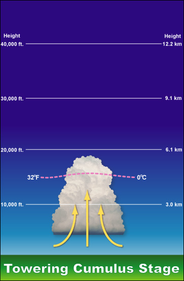
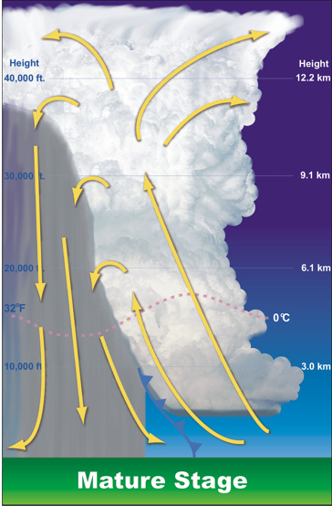
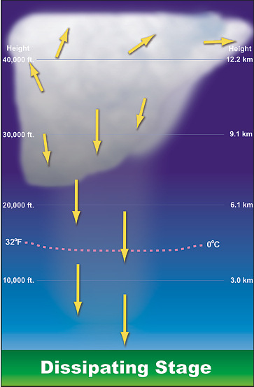
With a thunderstorm there are three stages shown below:
[columns] [span4]
[/span4][span4]
[/span4][span4]
[/span4][/columns]
A cumulus cloud begins to grow vertically, perhaps to a height of 20,000 feet. Air within the cloud is dominated by updraft with some turbulent eddies around the edges. As it matures the storm has considerable depth, often reaching 40,000 to 60,000 feet . Strong updrafts and downdrafts coexist. This is the most dangerous stage when tornadoes, large hail, damaging winds, and flash flooding may occur. In the dissipating stage the downdraft cuts off the updraft. The storm no longer has a supply of warm moist air to maintain itself and therefore it dissipates. Light rain and weak outflow winds may remain for a while during this stage, before leaving behind just a remnant anvil top.
A single cell thunderstorm can last from 30 to 60 minutes before it dissipates. Keep in mind though it is fun to watch a storm form near your area, lightning can strike as far as 10 miles from the cell.
There are four ingredients for the making of a storm – instability, moisture, lift and wind shear.
As a general rule, the surface dewpoint needs to be 55 degrees Fahrenheit or greater for a surface based thunderstorm to occur. A dewpoint of less than this is unfavorable for thunderstorms because the moist adiabatic lapse rate has more stable parcel lapse rate at colder dewpoints. Dewpoints at the surface can be less than 55 degrees Fahrenheit in the case of elevated thunderstorms. Instability occurs when a parcel of air is warmer than the environmental air and rises on its own due to positive buoyancy. Lifting mechanisms are fronts.
While most of this is simply explained here there is a lot more which goes into the reading of possible thunderstorm formations which is why we have our college educated METs to read all the data and form opinions via skew charts and other weather phenomena.
Up to 56 degrees in GR!
The official high/low at Grand Rapids on April 1st was 45/19 that low of 19 was the coldest low for April 1st since April 1st 1964 and it will be tied for 4th place for the coldest low for the date. It looks like a mild weekend coming up but after that there could be a cool down for mid month. We shall see how that plays out.
Slim
Nothing compared to just last year where we experienced 10 days in April where the high temp didn’t even hit 40 degrees.
Indy mentioned wearing shorts earlier, and I’m proud to say my streak of wearing shorts to work is still intact. The last time I wore pants instead of shorts to work was the last time we had a blizzard, in 2011. 8 years+, and that can be verified by anyone I work with. My legs never really get cold, and we never really get deep snow that would require otherwise.
It’s now been almost a month since our last snow of 1″ or more. And here comes another big warm up!
Many of us live in the shadow of Lake Michigan and that can be a thunderstorm killer but it can also be a thunderstorm maker. I live at what must be the right distance from the lake were thunderstorms develop overhead or just to the east of me. This seems to happen several times during the summer time. Also there are many other times when lightning can be seen to the northwest of me and then the storms dry out before getting to my house. So I live to the west of where thunderstorms can start or to the east… Read more »
Yep…same as Ada. Growing storms pass to the East, on their way to Lowell/Ionia. As far as lightning flashes, they are predominantly to our NW. ; ( Ada remains storm free.
Still waiting on a good thunderstorm mis them days nothing in the near future I see even across the heartland storm free!! I’m going to be planting some grass this weekend grilling probably breaking out the shorts Spring will be in full force …INDY!
Not sure about the wearing of shorts but soon I think I can go outside without a jacket on. Of course I like it 70 or better for that to happen. As for shorts for me that has to be 75 and above.
Slim
Finally this coming weekend we will start the SLOW climb towards some warm Spring temps! What a cold stretch it has been and what a winter!