I believe it was Slim who brought up the topic of lake shadows (or lake breezes) making or breaking storms in SW Michigan. Here is an explanation of what that is all about.
As incoming solar radiation reaches the earth, air over land areas heats up much faster than air over adjacent bodies of water due to the high specific heat capacity of the water. This causes the warmer air over the land to begin to rise. As this happens cooler air from over the nearby water moves in to replace the rising air. The result is a flow of air that moves from the water to the land, from cool to warm, during the daytime. We call this flow of air onshore flow or a lake breeze (if the flow of air were coming from an ocean or sea it would be called a sea breeze). The most favorable temperature differentials for the development of a lake breeze are found during the late spring, summer, and early fall.
The leading edge of a lake breeze marks a boundary between cooler air and warmer air. This makes a lake breeze similar to a cold front in many respects and they can serve as a focusing mechanism for afternoon showers and thunderstorms if moving into an area of sufficient moisture and instability. The larger the temperature difference between the air over the land and water becomes, the stronger the onshore flow is. Thus, the strongest lake breezes will be found during the afternoon when the air over the land is at its warmest. Seems in our area the lake breeze sets up just east of US 131.
In the absence of a prevailing wind there would be symmetric onshore flow along the entire shoreline of the body of water. When a prevailing wind is present the lake breeze will be skewed in the direction of the prevailing wind. Since the cooler air moving in to replace the rising warm air is much more stable, convective cloud development is minimized and a “shadow” is seen downwind from the body of water as an area of few clouds.
Weather History
March 31
1923: March goes out like a cold lion with record lows in the single numbers and lake effect snow showers.
2006: A tornado hits a few miles east of Jackson, taking down hundreds of trees and causing minor structural damage in the town of Leoni.
April 1
1923: Winter persists into April as temperatures fall to a record cold 8 degrees at Lansing and 9 degrees at Muskegon.
1970: An April Fool’s Day snowstorm drops 10 inches of snow on Lansing. Another 7 inches of snow falls the next day.
April 2
1977: A tornado outbreak in southern Lower Michigan kills one person and injures about 50 others. One thunderstorm spawned two violent tornadoes in Kalamazoo and Eaton Counties. Several homes and businesses were destroyed on the southwest edge of Augusta by the first tornado. The second tornado destroyed 21 homes and 28 outbuildings as it moved from near Bellevue to Eaton Rapids. Other tornadoes hit near north of Bath in Clinton County and southeast of Dansville in Ingham County.
April 3
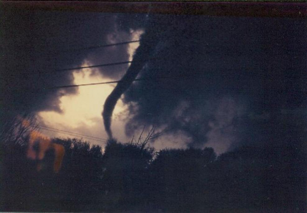
1956: Eighteen people are killed and over 300 injured as four powerful tornadoes strike western Lower Michigan. Hudsonville and the northwest suburbs of Grand Rapids are the hardest hit areas with 17 fatalities as homes and businesses were completely swept away by an F5 tornado. (feature image)
The afternoon of Tuesday, April 3rd, 1956 was warm and humid. Strong south winds had brought summer-like temperatures and humidity, with record highs in the upper 70°s at Muskegon and Grand Rapids. Holland and Kalamazoo both reached 80 degrees. Dew points were in the 60°s even near Lake Michigan. But a strong cold front was approaching from the west and out ahead of it, a line of violent thunderstorms had formed over Wisconsin and Illinois. The daily weather map for April 3rd, 1956 can be seen here. By 1 PM, a tornado had roared through Bancroft, Wisconsin, killing two people. Another tornado would level the town of Berlin, Wisconsin an hour later, leaving 7 more dead and 50 injured. Michigan was put on alert. The U.S. Weather Bureau (forerunner of the National Weather Service) office in Grand Rapids began notifying the public and civil defense officials that the risk of tornadoes across western Michigan was increasing. Some schools began letting out early, anticipating the severe weather to come.
The storms crossed Lake Michigan, and when they reached the west coast of Lower Michigan by late afternoon, they immediately began producing tornadoes. Three hours of terror would follow. At least four powerful tornadoes would be spawned, tearing their way across the landscape. When it was over, areas from Saugatuck to Traverse City, and inland to Middleville and Rockford were dealing with unprecedented destruction. Almost 20 people were dead and hundreds injured. Dozens of homes were obliterated. Many people’s lives were irrevocably changed.
The worst hit areas were Hudsonville and Standale, where entire neighborhoods were laid waste. Many people, some of them badly injured, helped in the immediate recovery by searching for neighbors trapped under the debris of what had been their homes. Police and National Guard units were dispatched to make sure roads were kept clear of sightseers, allowing the injured to be evacuated to hospitals. Dozens of seriously injured people were brought to hospitals in Grand Rapids, Holland, and Zeeland.
In the following days, the cleanup and rebuilding began. The Red Cross and Salvation Army would provide much needed supplies, including food, clothing and temporary housing. Homes and farms were rebuilt, even as family members recuperated in the hospital. But the impact of the storms would never be forgotten by those that lived through them. The following descriptions of the individual storms provide more details on that impact and include eyewitness accounts to the incredible fury of the storms that day.
[kad_youtube url=”https://youtu.be/JKNIBwY__bc” maxwidth=400 ]
1974: The worst tornado outbreak in United States history strikes from Illinois to Alabama, with 148 tornadoes killing over 300 people. In Michigan, a tornado kills two people as it tracks across Hillsdale and Jackson Counties.
April 4
2003: A devastating ice storm strikes central Lower Michigan. Heavy rain from thunderstorms falls into a layer of cold air near the ground and freezes on contact, creating sheaths of ice up to 3 inches thick that brings down thousands of tree limbs. It was estimated that 450,000 homes and businesses lost power during the storm and that nearly 50,000 people were without power for a week as persistent cold temperatures keep the heavy ice on the trees for 4 days after the storm. Crews came from four different states to help local utility companies restore power.
April 5
1982: Arctic air pours into Lower Michigan in the wake of a snowstorm and lake effect snows pile up over a foot across western Lower Michigan. The 12 inches of snow at Muskegon makes this the snowiest April day on record there.
April 6
1882: A tornado outbreak strikes Lower Michigan, killing 10 people and injuring more than 50 others. Tornadoes struck Midland and Kalamazoo Counties, killing one person each. Four people were killed in a tornado that moved between Bedford and Charlotte. Three people were killed in Oakland County by a tornado that passed between Clyde and West Highland. A tornado that struck east of Dansville in Ingham County killed one person. A barn and home were destroyed by a tornado a mile west of Charlotte, but no one was killed.
1997: A strong cold front moved through with a line of thunderstorms producing wind gusts to 70 mph and causing widespread damage across much of southern Lower Michigan.
We have another cold, windy, wet day outside! It should be a perfect Spring day for Barry to work outside! Wow!
Yes it is perfect for working outside! Dry here, been cutting since 7. Have to run to Gemmens though because I just blew the chain off my main saw.
You are a very bizarre person! You complain all winter about the cold and then you will work outside when the wind chills are in the 20”s! Very strange! If you think this is nice Spring weather you need to have your head examined!
Now that’s funny! I challenge you to find ONE post where I have ever complained about or said I do not like cold weather. Let me save you some time, I never have! The only complaining you will ever hear from me is with heat and/or humidity. Cool and dry is my perfect operating weather.
Beautiful spring day. The breeze made it feel cooler. A nice cool Spring will help us get thru it without
alot of severe weather like tornadoes. Less chance of them then
The wind is making it a bit chilly outside the sun is nice though..INDY!
The latest 8 to 14 day cpc shows the cold that Indy was referring to earlier! Keep the facts coming Indy! Rock on!
https://www.woodtv.com/weather/bill-s-blog/april-outlook/1894166663
That graphic is wrong and Bills blog is wrong! The latest cpc entrenches us in below normal temps starting next week! Get ready!
It is always interesting to watch thunderstorms form from our location with the lake shadow. It will be clear by us and to the West, but we have a perfect view of the clouds rising to our EAST. Somedays they grow so fast it’s like watching a nuclear detonation going off the way the clouds just mushroom up. I plan on making a time lapse video this Summer of the clouds exploding. Should be cool.
It is another cold, breezy morning! Wind chills are in the 20’s again! When will it ever end? Incredible!
And yet for all of your posts stating the same thing over and over, somehow yesterday ended up above average as well as last nights low, also above average. How can that be?
We will soon be above average for the month of April.
70’s and 80’s right? INDY!
Good morning we have some beautiful spring weather coming this weekend into early next week then we see a stormy pattern may develop especially.around next Thursday with maybe the S word again lol.. Enjoy today’s sunshine and warmth.. INDY!!
Yes Indy get ready for a major cool down next week! The trend this year has been below normal temps and that overall trend shows absolutely no sign of changing! Get ready to rock n roll!
Ah is this the third or fourth time you guys have been warning about snow? And yet, virtually no snow in over a month! How can that be?
How can that be? Because you are lying again. It has snowed at my house and in Gr 2 or 3 times during that time frame! Facts matter, this isn’t the Whitehouse!
Lol…The Whitehouse ….INDY!
Again it’s what the GFS model shows could change by next week and yes we can still get the S word this time of year lol…INDY!
I will add that on April 3rd 1975 the Bay City area had a big snow storm when over 15″ of snow fell. That came complete with high winds and thunder and lightning.
Slim
Just to add a little information on the lake breeze. I grew up on the east side of the state and lived in both Bay City and Alpena. We prevailing west wind so at times it is hard to tell the difference from the wind direction if it is a lake breeze or not. But on the east side of the state it is much easier to tell the difference. At Bay City the breeze from Saginaw Bay is more pronounced in the Spring and it is not unusual for it to be much cooler within 5 miles of the… Read more »