Congrats to Matt Stafford and the Rams for their victory over the Bengals last night in the Super Bowl. I am happy for Matt who finally had a team that helped show off his quarterbacking skills and a team which could close out a game. This was an exciting playoff season this year.
Yesterday we had a surprise five-inch dump of snow from a mesolow that tracked across southern Michigan around mid-afternoon. Snowfall lasted just less than 90 minutes which would have given us close to four inches per hour snowfall rates. This brings us to 17.8 inches for the month and 48.8 inches for the season. Yesterday’s high was 29° and the low -3.5°.
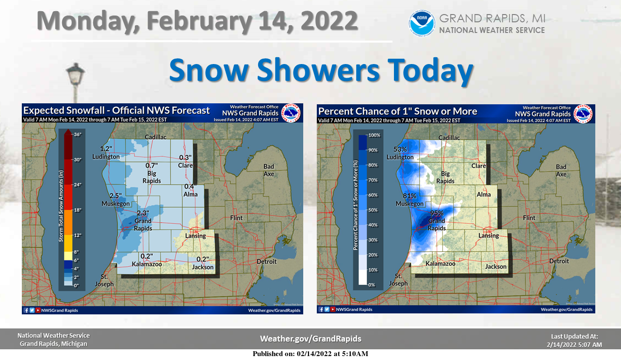
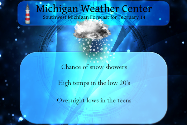
The lake-enhanced snow showers are expected today over most of Southwest Michigan. Due to the southwest winds today, the snow showers will mostly be north of a line from South Haven to Alma. Likely the largest accumulations today will be between Grand Rapids and Muskegon. Most other areas will see less than an inch of snow today.
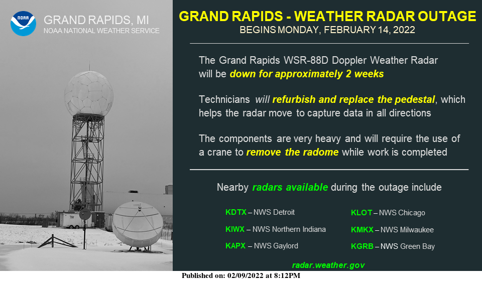
The Grand Rapids Weather Radar will be down for 2 weeks starting Monday, February 14, to refurbish and replace the radar pedestal as part of the radar Service Life Extension Program. During the outage, radar data can be found from nearby radars at radar.weather.gov.
Nearby radars include KDTX (Detroit), KLOT (Chicago), KIWX (SE of Goshen Indiana), KMKX (Milwaukee Wisconsin), and KAPX (Gaylord).
A fairly wet storm system is expected to impact Southern Michigan Wednesday into Thursday. As the system moves into the Great Lakes Wednesday, strong south winds will bring temperatures into the mid to upper 40s by Wednesday afternoon. The combination of those warm temperatures and the expected inch of rain in about 12 hours (mostly Wednesday evening into mid-morning Thursday) will cause considerable snowmelt. Given the ground is still frozen under the snow, the inch of water from the rain, combined with the inch of rain falling may result in some localized flooding and cause some of the river ice to break up and cause ice jams. On Thursday a wave on the trailing cold front is expected to move along the front. There is some question as to the track of this system. Likely there will be an area of heavy snow north of the track of the surface low. We are not sure where this will be at this point, however, our current best guess is near I-96. It is more than possible this area of snow could miss end up tracking south of the state so watch for forecast updates.
Forecast Discussion
...Clipper brings light snow today...

Regional radar shows light snow over southern Minnesota and western
Wisconsin moving southeast toward southwest Lower Michigan. The
models are trending toward decreasing the synoptic snow before it
gets here. However, what we`re likely to see is some enhancement to
the lake effect snow. Southwest winds are developing in advance of
this system. The favored area for accumulating snow with southwest
winds runs from roughly Holland to GR to Muskegon during lighter
wind southwest flow events. This is where the bulk of the snow will
fall today. Probabilistic guidance indicates about a 60-90 percent
chance of seeing an inch of snow today in that area. Locally,
perhaps two inches. The snow will wind down by mid to late afternoon
as the clipper departs the area.

...Still on track for a messy mid week system...

 A cold front is expected to move east to Lower Michigan Wednesday.
A strong southwesterly flow will draw up much warmer air. H8 temps
climb to +4c by mid day and so the precipitation that develops will
begin as rain; the models are in pretty good agreement with that.
The operational runs of the ECMWF and GFS have ebbed and flowed with
respect to strength of the low pressure waves that will ride
northeast along the frontal boundary. The latest GFS develops a deep
low on the front as it moves across Lower Michigan Thursday compared
to the ECMWF that is much weaker. The ensembles of each model have
been more consistent and show roughly an inch qpf that is divided
between rain Wednesday and snow Wednesday night and Thursday. It`s
too early to pin down accumulations but confidence is fairly high
that the snow that develops after the cold air arrives will be
plowable and likely cause travel disruptions.

The other item that keeps showing up in the models is the threat for
freezing rain and sleet in the transition zone between the rain and
snow. Once the cold air arrives, model soundings show a warm nose
around 800mb indicative of freezing rain for a few hours. While this
would cut back on snow accumulations, it may result in scattered
power outages.

The system moves out Thursday night and ridging moves in Friday
leading to dry weather.
The latest GFS rocks! How is that possible?
https://www.pivotalweather.com/model.php?p=snku_acc&rh=2022021418&fh=120
What perfect Winter day on and off snow showers with temps in the low 20’s for mid February we will take!! InDY
Considering the average high temp this time of year is 33 degrees, we will definitely take 10 degrees below normal, especially with all the warm weather nonsense!
Let it snow let it snow let it snow….InDY
Rock n roll will never die and winter will keep rocking for at least the next 5 weeks! Incredible!
Above average snowfall for February sofar and below normal temperatures for February no need for Junk models just facts baby …InDY
Yes the facts aLways served mookies BS! Keep rocking Indy!
These 2 facts and locked in stone! The snow just keeps coming and mookie distorts facts against the reality of all the cold and snow that keeps pummeling us! Incredible!
Let’s all root for the GFS model and let’s root against the Euro and mookie!
I would love the GFS to be accurate, however it usually overdoes snow ratios, hence why it is always a bit high on totals. Also there is a question of how fast the changeover will be from rain to snow (ice in between?).
But if the changeover happens fast and the snow ratios are above 12:1 then it would be more accurate. We will see!
Yes the mid range GFS is usually overblown, however I am more concerned about the track! The GFS is a little North and the Euro is South! Let’s hope they merge right over Kent county and then Bam!
So many junk models being posted on here. Still waiting on your one that showed GR getting 20″+ the last 10 days. That was only off by 15″ or so LOL
As for this week, NWS GRR says liquid from the storm is about an inch that will be divided up between rain, mix, and snow. If you figure a 50/50 split, that would be about 5″ on the back side of the storm. If we get more rain, that means 3-5″.
Lol, talk about junk comments!
>>>>>BREAKING WEATHER BULLETIN>>>>>The 12Z GFS is sticking to its guns and still has GR in the bullseye for HEAVY SNOW! Let’s see if Euro and the RDB jump on board because then we will have the verification we need to declare for a WSW! Stay tuned for later updates and get prepared now!!!!!!
http://wxcaster.com/gis-gfs-snow-overlays.php?STATIONID=GRR
BIG DADDY of a snowstorm is coming to a town near year you get prepared now..InDY
Rock on Indy! Keep the facts rocking and rolling!
Always a good week when we’re talking about melting snow and heavy rain in mid February. I love it!
You been saying that since January…lol..InDzy
Since November! He is nuts and delusional!
Possible Monster! Stay tuned!
Its looking that way darn….InDzy
about 3″ of new snow from about midnight Sat. to Noon Sunday, 2 miles east of Hamilton. Got out on the x-country skis for a bit. Such a good activity for cardio, balance, joints. Sorry, got a little off track (pun intended). Keeping fingers crossed for at least a couple of inches of the white stuff on the back side of that mid week system.
Great exercise and I participate in this activity myself! Just another great outdoor winter sport!
Let it snow, let it snow, let it snow! Remember we have 5 more weeks of winter! Hooray!
-4 here when I awoke this morning and now +2. Nostril-freezing cold this morning. We received more than 2.6″ of snow yesterday on this side of town, but it was the fluffiest snow I’ve seen in a long time. It made for easy shoveling.
Congrats to Matt Stafford. He’s a good guy on and off the field.
The overnight low here was +4 before it started the slow trend upwards. At this time it is cloudy and +12 here. There was 0.6″ of snow fall here yesterday and there was a brief period of heavy snow fall when most of that fell. To the east Lansing recorded 2.6″ of snow yesterday.
Slim