Yesterday’s high temp was 23° and the low was -2°.
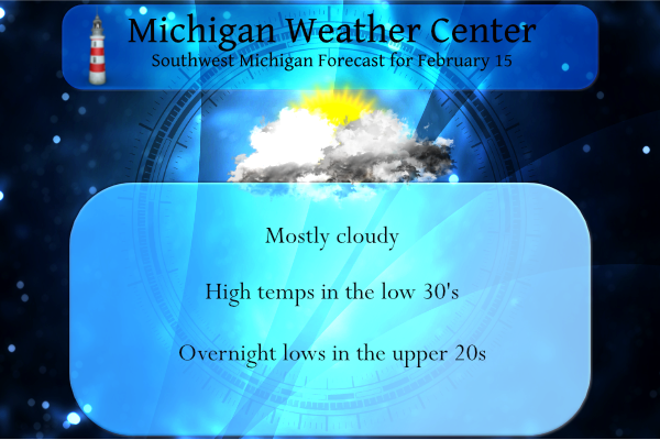
The weather will be quiet today as it makes up its mind on what it will be doing tomorrow through Thursday as a large messy storm system takes shape. There are no hazards, watches, advisories, or warnings at this time though we could see them later today. Below is the short-range discussion from the NWS Weather Prediction Center:
By Wednesday night and into Thursday, the aforementioned upper-level
trough is forecast to eject into the Southern Plains and spawn an area of
low pressure near the Texas Panhandle with an expanding precipitation
shield found toward the northeast. At the same time, a slow moving cold
front is anticipated to bisect the country from the Great Lakes to the
Southern Plains. The precise location of this cold front as it sinks
southward on Thursday will be crucial to determining which locations see
significant snow, rain, or a wintry mix. At the moment, the greatest
chances for disruptive snow extends from south-central Kansas through
central Missouri, northern Illinois, and into central Michigan. Areas of
sleet and freezing rain will likely be found just to the south of the
heaviest axis of snow, but rather high uncertainty remains regarding where
exactly the transition zone will set up. Residents are urged to stay tuned
to the latest forecast so quick preparations can be taken before the storm
begins.
Keep in mind these are only guesses at this point:

Forecast confidence is increasing for widespread snowfall on Thu—here are some main messages as of this update. Expected snowfall accumulations will be posted in a later update. Aside from snowfall, there is also a risk of river ice jams this week in southern Lower Michigan; please check for river updates in the days ahead.
Forecast Discussion
- Good deal of uncertainty remains for Wed-Thu System

Not much going on for today preceding the more potential noteworthy
event for Wed-Thu. Some lingering light snow showers continue this
morning for western areas. This is the result of sufficient over-
lake instability and a westerly component to the wind in the cloud
layer. These snow showers are expected to taper off as the flow
aloft becomes more southerly, and the sfc flow will be from the SE.
Some partial clearing is expected with the low clouds blowing out,
and lingering mid and high clouds holding in.

There is good consensus that there should not be many significant
impacts on Wed for the entire area, as pcpn should be all rain
during the daylight hours. Temperatures will be comfortably above
freezing as the rain develops overhead over the course of the day.
The only potential impact there could be hydrology related with the
rain and melting snow. We will address that more in the Hydrology
section below.

The uncertainty begins Wednesday night, and then continues through
the end of the event around Thursday evening. The uncertainty comes
in with regards to p-type and heaviest precipitation axis/p-type
amounts. The remaining uncertainty, and still a decent amount of
time before the impacts would arrive late Wed night/Thu morning will
keep us from issuing any watches at this time.

What is known is that we will see a gradual changeover of rain to a
wintry mix before going to all snow. This occurs as colder air is
drawn to the SE, and undercuts the warmer air aloft for some
uncertain amount of time. Many of the international models/ensembles
indicate that this window of mixed pcpn will be shorter, vs. a
longer potential in the american guidance. That then goes along with
where the heaviest pcpn axis ends up being. That is just another
layer of complexity.

The collaborated forecast will reflect somewhat of a middle of the
road scenario. That would be rain, changing to a little potential
freezing rain, then snow. The heaviest axis would be generally
across the southern half of Lower Michigan. Our thoughts of where
this might trend would be a little more to the south. We believe
that the further north solutions may be too far north for two
reasons. These reasons are there will be drier air feeding into the
area from the NE, and the further north solutions look to have the
mid level wave over-developed, which brings the sfc low a little bit
further north. The sfc low is only a part of the forcing, as this
event will be largely driven by a coupled upper jet scenario. This
system looks quite similar to the event from Feb 2nd, with the
difference being the presence of a mid level wave this time.

- Clipper system expected for later Friday

The pcpn will wind down quickly Thu evening, with a brief break in
pcpn Thu night and Fri morning. We will get back into the NW flow
once again, and a clipper will drop SE through the area. The brunt
of pcpn with that clipper will likely stay north of the area closer
to the core of the wave, with some light snow down here.

- Quiet and seasonable for the weekend and Monday

Once the late Fri/Fri night clipper moves east of the area, we
should see a fairly quiet and tranquil period through most of
Monday. The Polar jet retreats far enough North to keep the
unsettled weather up there. The upper flow off of the Pacific will
bring in a more mild air mass, vs the arctic from the North that has
dominated more recently.
Hydrology
We are monitoring two different concerns with regards to hydrology
with the upcoming system. The first will be snow melt and rainfall
on the front end of the upcoming system. Then the ice jam potential
aspect with the break up of ice with the up and down nature of the
temps along with runoff expected.

The good news is that the rivers are generally running around
normal, or even a little below normal over the Muskegon River basin.
This is good going into a melt/rain event like this. Much of the
area has less than 2 inches of water in the snowpack, with a little
over 2 inches toward the lakeshore. Much of this will probably melt
and run off with the ground frozen everywhere.

The good news is that new pcpn in the form of rain that would runoff
would be less than an inch. Heaviest amounts likely further south.
With rivers running at or below normal, they should be able to
handle this. A good chunk of the pcpn will come as snow, which will
not add to the runoff at this time.

The uncertain part of this is the ice jam part. There is not a lot
of ice on the Kalamazoo River, so there is less of a threat there.
The Grand and Muskegon basins do have more ice, and could end up
breaking up. Then it all comes down to how much breaks up, and then
hangs up in the typical areas. We will continue to monitor this, but
there is not a significant concern for now.
All this hype by a few on here of a monster snowstorm and now WOOD is saying barely any snow for GR. This is too funny!
The GFS model has been bad this year, even the mid and short range, however this winter has been incredible! Plenty of cold and snow! Keep it rocking!
It will be interesting to see when tornado season really kicks in down in Dixie Alley and the southern Plains. Could be an active spring for tornadoes there (even up into the Ohio Valley). For those that don’t know much about me I DO storm chase down in Mississippi and Alabama during the spring. I was down in Alabama March 17 ,2021 for the High Risk event and got an amazing shot and video of a tornado in Moundville, Alabama south of Tuscaloosa. I plan to chase a MDT/high risk setup this spring as well.
This event definitely has some similarities to the Feb. 2 storm from the perspective of rain with really warm temps changing to snow and a tight NW edge to the heavier snow. Not saying the same thing will happen again but definitely similar in that perspective. Crazy how our northern and northwest counties can’t seem to get a big storm this year. I am happy with the 10” storm on Feb 2 at my house so regardless of the outcome of this storm I have no complaints about this winter. Been a great winter for my area of the state.
Well Ellen just showed 1 to 3 inches for most of Kent County, 1 inch closer to my area and 3 inches in extreme southern Kent County! KEEP IT ROCKIN!! I love short winters like this one!!
The big daddy storm missing GR again?! How can this be?
Awesome!! My point forecast only shows less than 3 inches of slop on Thursday!! If the axis keeps moving south like it has been on recent runs, it may totally miss me!! Wednesday Rain, mainly after 1pm. High near 45. Breezy, with a south southwest wind 18 to 22 mph, with gusts as high as 43 mph. Chance of precipitation is 90%. New precipitation amounts between a tenth and quarter of an inch possible. Wednesday Night Rain before 4am, then freezing rain between 4am and 5am, then snow after 5am. Low around 28. Southwest wind 7 to 17 mph becoming… Read more »
The point forecast for here also says 3” for Thursday.
Just took a peek at the 18Z GFS. There has been a slight southward shift to the heaviest snow. Heaviest axis of snow shown for areas especially southeast of Grand Rapids.
Love it!! Keep that thing moving south!!
From the NWS PM discussion: “We then turn our attention to the southern stream low which is also tapping Gulf moisture as it tracks through the Ohio Valley on Thursday. Strong frontogenesis will be across the southern half of Lower Michigan, with a stripe of 6 inches or more of snow expected to result somewhere across our central or southern forecast area by Thursday night. The location is still to be pinned down as the 12Z GFS and ECMWF stubbornly maintain their differences, with the GFS being further north. Because of the model guidance being fairly evenly (and persistently) divided… Read more »
As predicted, the 44% Great Lakes Ice Extent on February 5th looks to have been the high for the season. This will be the second lowest in the last 4 years. Except for a few blips, most of the winter has been below average ice to go with our below average snow.
Actually the Great Lakes ice extent reached 49.4% yesterday.
As usual mookie is trying to make it sound like a mild winter! He could not be more wrong as usual!
It depends who you’re referring to. There’s a number of organizations that measure it with slightly different results. According to Bill Steffen, ice coverage was 41% Monday.
Bill Steffen said 49.4% yesterday. In his tweet, unless he made a typo in the tweet
Update from the National Weather Service update shows 4-8” of snow for a good chunk of the area.
I was just about to mention that haha. Looks like this could be a long storm, rain Wednesday into Thursday morning and then snow all the way to Friday morning
Definitely a very large snowstorm heading our way! Enjoy everyone!
Yeah, that’s basically what they were saying early this morning too.
Well the 12Z Euro offers no help in answers for the upcoming system.
The weather channel app has 40s and wind tomorrow morning, rain beginning in the afternoon and lasting through much of the night, and a changeover to snow around 6-8am Thursday morning… not sure how accurate this is, but just a possible timeline of events.
Also we have had many notable floods in the last 2 weeks of February in recent years. Definitely need to pay attention to flooding potential.
After the ice jam that flooded parts of my town of Portland in 2019, we are kind of on a heightened awareness around here when it comes to the ice melt causing jams.
GFS model still looks good for west Michigan get to the store now we have 6+ inches of snow coming for west Michigan with Winter storm watches coming this afternoon…InDY
The latest GFS overall remains unchanged from the 06Z run. Waiting on the new Euro data
Hopefully the Euro lines up with the GFS
Agreed. I will say the GFS has been holding strong and fairly consistent run after run.
The Latest Hydrologic Outlook …Minor flooding and Ice Jams possible this week… Rain and rapidly melting snow will bring river levels up significantly in the Grand and Kalamazoo River basins this week. A few locations could see water levels near or slightly above bankfull. These conditions are also favorable for ice jam formation, especially along the Grand River. A rapid spring melt pattern is moving into southern Lower Michigan. Between 0.5 and 1.0 inches of rain is likely Wednesday night and Thursday morning. In addition, between 1 and 1.5 inches of water is currently contained in the snowpack along and… Read more »
WINTER STORM WATCHES COMING FOR GR ??? STAY TUNED …InDY
Will be interesting to see what the 12Z data shows. Crazy the spread in data when the system is not far away.
Weather balloons have been lifted last night so the next GFS run should be interesting or tell the tale of the storm track…InDY
Agreed and we need the Euro model to move to the North!
I have about 6 and 7 inches of snow on the ground pretty amazing for mid February and its still snowing outside who knew??? InDY
NWS reporting 5 inches before all the heavy rain and melt. Always more snow at Indy’s LOL
Yes I dont live in GR sorry …InDy..
Where do you think Mookie lives ????? and there is never a report from Mookie’s house. Do you ever wonder why????
Slim
Rockford
YES and great call Slim….InDY
Just another typical mid winter day! Below normal temps and a snowstorm in our future! Wow!
Heavy rain and 46 degrees tomorrow. Just a typical mid winter day LOL
Lol More Grasping…InDY
What a winter! The cold and snow just keeps coming! Get ready for another snowstorm! Incredible winter for outdoor winter sports! The best in years and no change in sight!
WOOD now has three days upcoming between 40-46 degrees. 50 degrees looks possible for parts of Lower Michigan tomorrow. Winter is dying.
We have 13 days to March, which is crazy to think about
So far this year there have been just 14 days above average and 32 days below average so I would think it is time for it to warm up. So far this winter season there have been 62 days with at least 1″ of snow on the ground the average number of days is 67 so this will end up as a typical winter in the Grand Rapids area.
Slim
You been saying this since December anything else ?? Lol..InDzy
He’s been spewing this garbage since November! Remember November, it was another above average month for snowfall! Incredible!
Well, the junk models posted by some on here showed 16″ of new snow yesterday. Today, we are down to 4-8″ LOL
I wonder what tomorrow will bring.
I recorded just over one inch of new snow fall here early last night. This was a fluffy lake effect snow and was very easy to clear off the driveway this morning. There is now 6″ of total snow on the ground there at my house with about 3″ of light fluff and 3″ of very hard back snow. Officially for the month of February Grand Rapids is now at 12.3″ and for the season GR is now at 57.9″ that is still -2.3″ below were GR should be on February 15th. Today will be the 52nd day in a… Read more »
I find it interesting that there is such uncertainty just 48 hours out.
The ice fishing has been tremendous around west Michigan so much ice you can drive a car out on the lakes and put some music on..Probably one of the best Winters in years around here and we have plenty more to come shuuu….InDY
Another inch of snow last night and now a pending snowstorm! What a winter and it just keeps going and going! Don’t worry if we don’t get more than 8 inches of snow the usual warm weather fanatics will say not much of a storm! What a joke! Bring on the SNOW!!!! Rock n roll will never die!
And hardly a flurrie in Zland Michigan lol ..Nother cold morning our furnace has been cranking since November crazy…InDY