Continuing with our education on weather we begin this week with a study on the jet stream. Most of the sources for the series I have posted come from NOAA and the NWS.
Jet streams are relatively narrow bands of strong wind in the upper levels of the atmosphere. The winds blow from west to east in jet streams but the flow often shifts to the north and south. Jet streams follow the boundaries between hot and cold air.
Since these hot and cold air boundaries are most pronounced in winter, jet streams are the strongest for both the northern and southern hemisphere winters.
 The earth’s rotation divides this circulation into three cells. The earth’s rotation is responsible for the jet stream as well.
The motion of the air is not directly north and south but is affected by the momentum the air has as it moves away from the equator. The reason has to do with momentum and how fast a location on or above the Earth moves relative to the Earth’s axis.
Your speed relative to the Earth’s axis depends on your location. Someone standing on the equator is moving much faster than someone standing on a 45° latitude line. In the graphic (left) the person at the position on the equator arrives at the yellow line sooner than the other two.
Someone standing on a pole is not moving at all (except that he or she would be slowly spinning). The speed of the rotation is great enough to cause you to weigh one pound less at the equator than you would at the north or south pole.
The momentum the air has as it travels around the earth is conserved, which means as the air that’s over the equator starts moving toward one of the poles, it keeps its eastward motion constant. The Earth below the air, however, moves slower as that air travels toward the poles. The result is that the air moves faster and faster in an easterly direction (relative to the Earth’s surface below) the farther it moves from the equator.

North hemisphere cross section showing jet streams and tropopause elevations
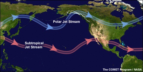
In addition, with the three-cell circulations mentioned previously, the regions around 30° N/S and 50°-60° N/S are areas where temperature changes are the greatest. As the difference in temperature increases between the two locations the strength of the wind increases. Therefore, the regions around 30° N/S and 50°-60° N/S are also regions where the wind, in the upper atmosphere, is the strongest.

The 50°-60° N/S region is where the polar jet located with the subtropical jet located around 30°N. Jet streams vary in height of four to eight miles and can reach speeds of more than 275 mph (239 kts / 442 km/h).
The actual appearance of jet streams result from the complex interaction between many variables – such as the location of high and low pressure systems, warm and cold air, and seasonal changes. They meander around the globe, dipping and rising in altitude/latitude, splitting at times and forming eddies, and even disappearing altogether to appear somewhere else.
Jet streams also “follow the sun” in that as the sun’s elevation increases each day in the spring, the average latitude of the jet stream shifts poleward. (By Summer in the Northern Hemisphere, it is typically found near the U.S. Canadian border.) As Autumn approaches and the sun’s elevation decreases, the jet stream’s average latitude moves toward the equator.

Jet streams are often indicated by a line on a weather map indicating the location of the strongest wind. However, jet streams are wider and not as distinct as a single line but are actually regions where the wind speed increases toward a central core of greatest strength.
One way of visualizing this is to consider a river. The river’s current is generally the strongest in the center with decreasing strength as one approaches the river’s bank. Therefore, it is said that jet streams are “rivers of air”.
Here is the NWS thoughts on this spring…

Here is today’s outlook from the SPC – we are in the general thunderstorm area.

We should see some rain later this afternoon and evening with a slight chance of a storm south of I96…

Cold, snow and wind is coming!
71* degrees out at thee YARDofBRICKS clouds are rolling in and so are the bugs! It’s beautiful outside …INDY!
Great golf weather this weekend but watch out for the cold, wind and snow next week!
Wow! GR is up to 71 degrees! Incredible warmth for the beginning of April
Nice !!
76* !!!!! @1455
More good information from MV. Yesterday’s high of 65 at GR was the warmest high since October 10th of last year. And if the low so far today of 48 holds until midnight it will be the warmest low also since October 10th when GR had a low of 62. So, while it has been mentioned on how mild this winter has been there has been very little on the fact that is has been a long cold season none the less. Here are some snow depths in the UP as of yesterdays AM The Sault 23”, Marquette 20” Munising… Read more »
I have worked for the West Michigan Whitecaps for 13 years and the yesterdays home opener was the warmest in that time and was told it was the warmest home opener since 1997
Slim
Beautiful day for the home opener this year! Last year, I was wearing full Carhartt gear. You just never know what MI baseball will be like in April!
Another very informative read today MV! I’ve been learning quite a few new things lately I had not previously known about. The jet stream is a interesting feature of our atmosphere that I’ve always found fascinating.