What a nice day yesterday – we had a high of 76° when the sun popped out and .59 of an inch of rain in the evening.
There are winter storm watches in place for South Dakota for 6 to up to 18″ of snow and strong winds. This system will probably bring us a mixed bag of precipitation with a bit of snow north of I96 and possibly some storms Thursday and Friday. We will keep on eye on this….
Now we continue with the series on weather and storms.
There are 3 horizontal motions that make up the winds within a tornado. These three motions are the tornadoes forward motion, The parent tornado circulation, and vortices within the parent tornado circulation. These three motions together make the wind speeds within a tornado extremely variable.
Let’s look at each in detail. The quicker a tornado moves, the faster the winds will be on one side of the tornado and the slower they will be on the other side. This same phenomena occurs with hurricanes, on one side of the storm the hurricane’s forward motion is added to the hurricane’s parent wind speed and on the other side the forward motion is subtracted from the hurricane’s parent wind speed.
(Analogy, if I am running at you and throw a baseball to you, all else being equal, that baseball will get to you quicker than if I was running away from you and threw the baseball to you). The forward motion of a tornado is highly variable (anywhere from nearly stationary to over 70 miles per hour).
The second motion within a tornado is the primary rotational circulation. This is the primary (usually counterclockwise spinning) vortex which makes the tornadoes circulation. This is the primary circulation which determines the wind speeds within a tornado. This circulation can range from less than 70 knots to over 250 knots. There are several factors that determine this wind speed. Some of these factors include helicity (determined by low level speed and directional wind shear), small scale processes, CAPE, and the maturity of the mesocyclone.
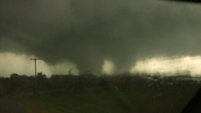
The third wind that makes up a tornado are small-scale vortices. These can be thought of and look like mini-tornadoes within tornadoes. They are caused by turbulent friction with the earth’s surface along with the hydrodynamic low within a tornado and are most noticeable in strong tornadoes.
Relative to a surface observer, the winds on one side of these mini-vortices will be much stronger than on the other side. This is because on one side the tornadoes primary rotational motion is being added to the motion with the mini-vortex and on the other side the tornadoes primary rotational motion partially or completely cancels the motion within the mini-vortex. You can use the same baseball throwing analogy that was given before.
WHAT ARE THE CONSEQUENCES of all these constructive (adding of winds together) and destructive (subtracting of winds from each other) wind motions? The result is extremely variable and chaotic wind motions within a tornado, especially near the earth’s surface due to friction. These wind motions are changing constantly (mini-vortices may only exist for a few seconds, then new ones develop and dissipate). This is thought to be one of the reasons why one house can be completely obliterated while a house 100 feet away only has minor damage. Perhaps the house which got obliterated suffered from constructive wind (forward motion side of tornado, addition of winds with a mini-vortex with the tornadoes primary rotational circulation) or perhaps the gradient of wind near a tornado is extremely large, or a combination of both.
All these competing and constructive wind motions cause a high variability of wind at the surface in a tornado which can lead to phenomenal and strange damage patterns and stories of extreme damage next to little damage. I must say a lot of what has been stated in this essay is still under research, but this does give you a good working model for wind motions associated with a tornado. (cite: Met Jeff Haby)
In Summation:
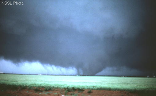
Many tornadoes contain smaller, rapidly spinning whirls known as subvortices, or suction vortices; but they are not always as clearly visible as in this big tornado near Altus OK, on 11 May 1982. Suction vortices can add over 100 mph to the ground-relative wind in a tornado circulation. As a result, they are responsible for most (if not all) cases where narrow arcs of extreme destruction lie right next to weak damage within tornado paths.
Subvortices usually occur in groups of 2 to 5 at once (the 6 or 7 evident here being uncommon), and usually last less than a minute each. Tornado scientists now believe that most reports of several tornadoes at once, from news accounts and early 20th century tornado tales, actually were multivortex tornadoes.
MV great post today. Great info.
Beautiful Monday!! Saturday we were out to Lake Michigan at Holland State Park – it was so nice. There is still ice on the lake in spots and we could hear it break and fall into the water. Also there was still alot of ice on the pier. We saw someone in the lake, somebody walking on ice – really a few and a couple of people parasailing. Later some guys had an old souped up car rally going on. An old couple walking past us as we sat and enjoyed the sites asked us if we thought we would… Read more »
Local met tonight said Thursday may have wet snow in the am and thunderstorms in the pm.
European model shows 6-8 inches of snow now for GR Thursday I’m sure it’s overdone but snow chances are coming in more and more now with this storm .. INDY!
68* for a high here today – I am an early riser – love to hear all the birds at sunrise then at sunset all the frogs are singing in the ponds – lots of frogs this year….
The GR nws is predicting accumulating snows for GR and points northward! Nothing like a mini snowstorm in mid April! How incredible is that? Far more incredible than a couple days in the 70’s in April!
False. Snow in April is common. Back to back 70’s in early April isn’t quite as common.
April 7th, 2018: GR had a high temperature of 30 degrees
April 7th, 2019: GR had a high temperature of 74 degrees
What a difference a year makes!
Get ready for cold wind snow and rain!!!
Maybe in the UP?
Your ignorance shows no limits! My current point forecast gives me 2.4 inches of snow and 30 mph winds! Just another typical Spring day in MI!
More 70’s in lower Michigan today! Back to back 70+ degree days! Does it get any better than that for early April?
Slim I’m seeing that maybe a nice line of storm’s coming through Thursday ..INDY!
Yesterdays high/low of 74/48 was the warmest April day since April 9 2017 when GR had a high/low of 75/50. Bottom line is that days in the 70’s and even 80’s are not that rare in April.
Slim
With the storm systems we have coming in the next few weeks we will have to keep a eye out for strong storms. The best time for strong storms is with strong cold fronts.
Slim
Bill Steffens says we are below average on severe weather now for this time of year I’m thinking we hace been below average for the last 5 or 6 years now storm free continues in Grand Rapids.. INDY..
Maybe WOOD will have to change Storm team 8 to storm free 8
Slim
Lol! INDY!
I believe 2018 was our 4th above average year in a row for temps. Will 2019 be our 5th?
It is true that GR has had 4 years in a row where the mean temperature has been above average. As for 2019 it is too early to tell for sure will see how we stack up around October.
Slim
GR is now +2.1 degrees above average for April before another warm day today.
Well after 5 out of 6 below normal Months this feels really good!! Let’s be skeptical though +2.1 could vanish very fast in April lol! INDY..
GR hit 74 degrees yesterday – about 10 degrees warmer than forecasts! Skeptical Indy got his 70’s in the first week of April. Who knew?