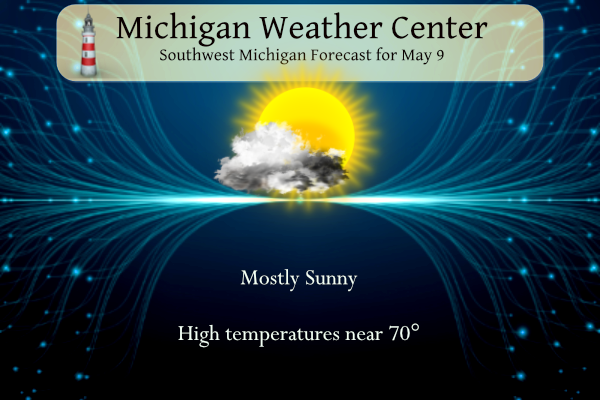
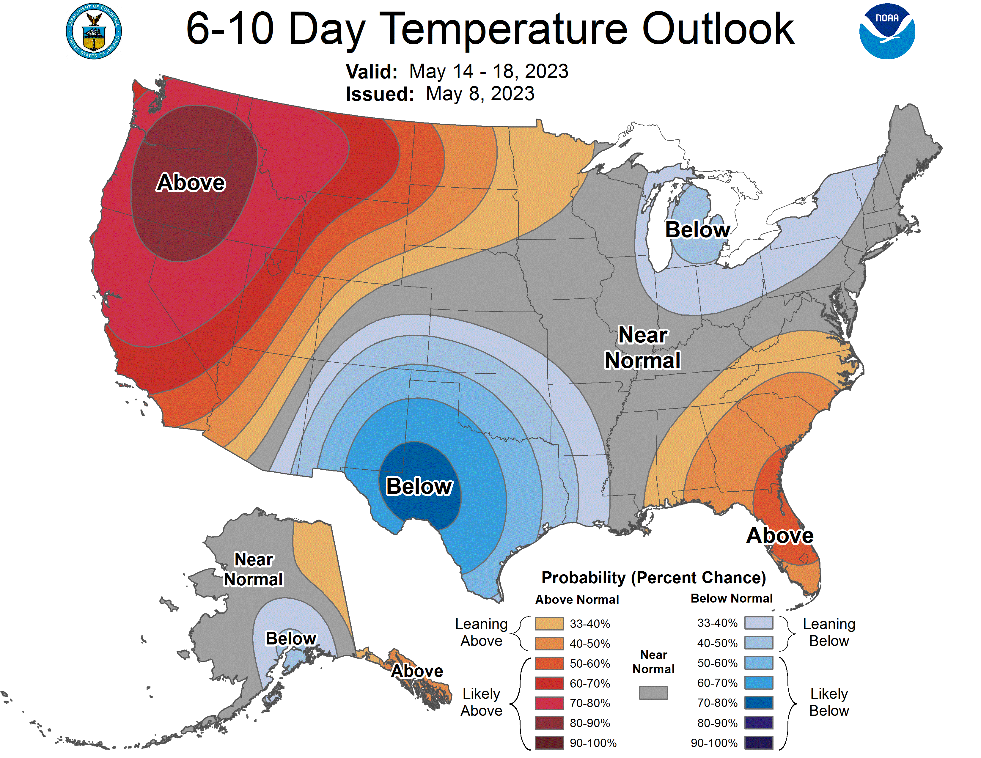
Most of the rest of the week will trend toward warmer temperatures and sunny skies. The next chance of rain is on Friday, with continued chances of rain into the coming weekend. Normal daytime highs begin their climb into the 70s through mid-May and beyond. The latest from the CPC is showing below-normal temperatures and dryer conditions beginning next week through the end of the month.
U.S.A and Global Events for May 9th:
1918: An F4 tornado moved across Floyd, Chickasaw, and Winneshiek Counties in northeast Iowa from two miles north of Pearl Rock to Calmar. Two people died east of Calmar when the tornado was a mile wide. Losses in and near Calmar totaled $250,000. Overall, this tornado killed seven people and injured 15 others.
1933: An estimated F4 tornado moved through Monroe, Cumberland, and Russell Counties in Kentucky along a 60-mile path. The town of Tompkinsville, KY was the hardest hit with 18 people killed. Overall, 36 people lost their lives. Click HERE for more information from the NWS Office in Louisville, Kentucky.
1966: Record snows fell in northeastern Ohio and western Pennsylvania, including 3.1 inches at Pittsburgh and 5.4 inches at Youngstown Ohio. Snow also extended across parts of New York State with eight inches reported in the southern Adirondacks.
1990: The 1990 Machilipatnam Cyclone was the worst disaster to affect Southern India since the 1977 Andhra Pradesh cyclone. This category four on the Saffir-Simpson scale had a severe impact on India, with over 967 people reported having been killed. Over 100,000 animals also died in the cyclone with the total cost of damages to crops estimated at over $600 million (1990 USD).
1995: An F3 tornado produced $10 million in damages along its 40-mile path across central Illinois. The tornado caused significant damage in Cantrall where three homes were destroyed, 10 had significant damage, and 11 had minor damage. The roof and interior of a grade school suffered extensive damage. The tornado passed about 2 miles southeast of the new NWS Office in Lincoln, Illinois.
Grand Rapids Forecast
5 23 grrForecast Discussion
-- Dry, Mostly Sunny, Warming Through Thursday --

Confidence in the forecast through Thursday is medium to high
with very little spread in the ensemble guidance. Upper level wave
pattern across the CONUS will amplify with heights building over
the central US and troughs sharpening over the western US and east
coast. Surface high pressure will be centered over Lower Michigan
this evening, then gradually shift toward the mid-Atlantic states
by Thursday.

Weak northerly flow over our area today will keep air fairly dry
with dew points falling into the 30s in many locations. The dry
air, light winds, and mostly clear skies tonight may promote frost
in the typically cooler spots near and north of US-10. A return
to more southerly flow Wed/Thu will bring warmer-than-normal
temperatures and somewhat higher dew points back, though still
rather comfortable. Temperatures will often be much cooler right
near Lake Michigan.

-- Rain Chances Friday to Sunday --

Confidence is low to medium in the specifics of rain amounts and
temperatures, though what is most likely is a period of cloudier
weather and a cooling trend between Friday and Sunday. Convectively
augmented 500 mb vorticity over south-central Texas Tue-Wed will
be drawn northward ahead of the trough over the Rockies on Thu.
This disturbance may damp and shear out as it approaches Michigan
Friday, though could provide some extra impetus for precipitation
development north of the surface warm front, more probable in
southern Michigan.

The suite of ensemble solutions also make no promises for
Saturday or Sunday as the upper-level trough or developing low
over the Rockies becomes cut off over the Dakotas (within an
emerging saddle point in the synoptic height charts across North
America), only for a fragment of it to be potentially drawn into
larger-scale northern stream troughing that is favored dig into
the Great Lakes region late in the weekend. Narrow corridors of
mostly elevated convection can`t be ruled out at some point during
the weekend.
MV welcome back. Hope you have a speedy recovery.
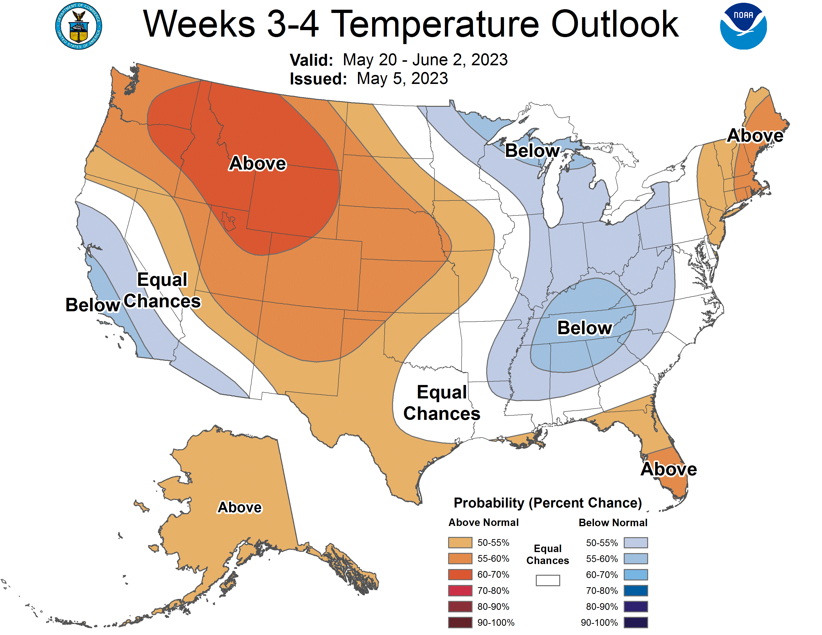
I love the latest CPC! Cool weather well into June! The cool pattern is locked in and no change is in sight! Incredible pattern set up! Wow, just wow, WOW!
Today really is about as great as it gets for weather. We drove over to Holland to the tulip time festival. It was a picture perfect day to be out walking around, taking pics, shopping, out to eat etc.
It was beautiful out! You couldn’t ask for a better day.
70’s and sunny in early May with even nicer days ahead. We sure have been getting spoiled with the weather lately!
At this time the long range outlooks still looks cool and dry.
https://www.cpc.ncep.noaa.gov/products/predictions/610day/index.php
and
https://www.cpc.ncep.noaa.gov/products/predictions/814day/index.php
It there are a lot of clear days with low dew points there will be a chance of frost. Make sure if anyone has planted frost sensitive plants to have something to cover them with.
Slim
I see storm team 8 has a high of 58 in 8 days… that would be awfully chilly for mid-May. We will see. I think most of this “cool down” will have highs in the 60s.
A few days with highs in the 50’s are not that uncommon in May. In fact there could still be days with highs in the 50’s even in June. Most days should see highs in the 60’s but can not rule out a few days in the 50’s It all depends on how “cool” it will be. But what is more important this time of the year are what the lows will be.
Slim
They do that all the time to troll I think. They had mid 50’s for this Friday at their end of their 8-day several days ago. Now it’s supposed to be almost 80 LOL
Our local TV station has 68 for that same day.
What more Blue thats been the trend since November nothing new just means more hoodiee and bon fire weather thats a plus for INDY no hot air inview love it!! INDY
It could be “don’t forget you jacket” weather. Hopefully it will just be “don’t have to” that is don’t have to have the heat on and don’t have to have the air on.
Slim
I love seeing all that blue as far as the eye can see on the CPC maps! May could end up as another below normal temp month just as March was for GR! Clearly the cool pattern is dominating! Incredible pattern! Keep it rocking and rolling!
Lansing has now had 4 warm days in a row – with more upcoming! Nice warm stretch here. May should be above average temps soon.
It’s a cloud free, sunny morning without hardly a breeze. Dew is glistening everything is very green. The next three days look perfect – sunny and flirting with 80 degrees. I think it’s time to bust out the car polish/wax and the buffer.
Have a great Tuesday friends. Try to get outside and enjoy this beautiful weather. And remember, make someone smile. 🙂
This is about as nice as it can get. Sunny, warm, no wind, not humid. I hope everyone is able to enjoy the weather the next few days!
Hope you and your son are feeling much better!!!
We are, thanks. Our boy went back to school yesterday. We’re all back to 100%. 🙂
Good to hear!
What? Cool the rest of May! Who would have thought? Keep the cool Spring rocking right into summer!
Could the current long range outlook point towards the start of a long cool spell that could last most of the summer? At this time there is no so called “blowtorch” in the foreseeable future for Great Lakes area. Could it be a “don’t forget your jacket” type summer?
Slim
For today the average H/L is now 67/51 the record high of 88 was set in 1896 and 1930 the record low of 23 was set in 1947. The record snow fall for the day and the month of May of 5.5” was set in 1923. At Lansing the record snow fall amount of 11.5” fell. It was warm before this snow fall so there were leaves on the trees that year. The record rain fall at Grand Rapids for today is 4.10” in 1956.
Slim
The next 6 days look mostly warm with highs in the 70’s to around 80 before dropping down to the 60’s on Sunday. The dew points will be low so it will feel cooler than the temperature would indicate.
Slim
Good morning! Yesterday’s official H/L at Grand Rapids was 61/51. There was 0.10” of rain fall and no sunshine. Here in MBY the overnight low so far is 43 and that is the current reading with clear skies. I recorded 0.11” of rain fall.
Slim