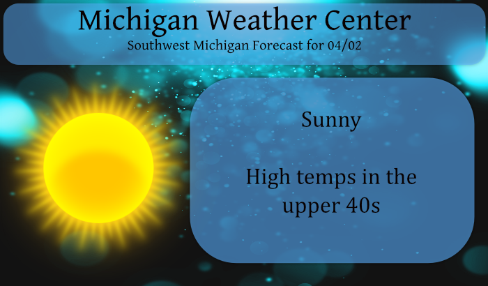
We have a cold 17° this morning at 6 am. Yesterday’s high was 39°,
Today we should see a 10° improvement in temps. Temperatures will warm considerably over the weekend, and remain warm next week. Gusty winds and dry conditions on Saturday will renew concerns for brush fires to get out of control. Burning yard debris is discouraged. We have had a few brush fires around the area which got out of control even when attended by a well-meaning citizen.
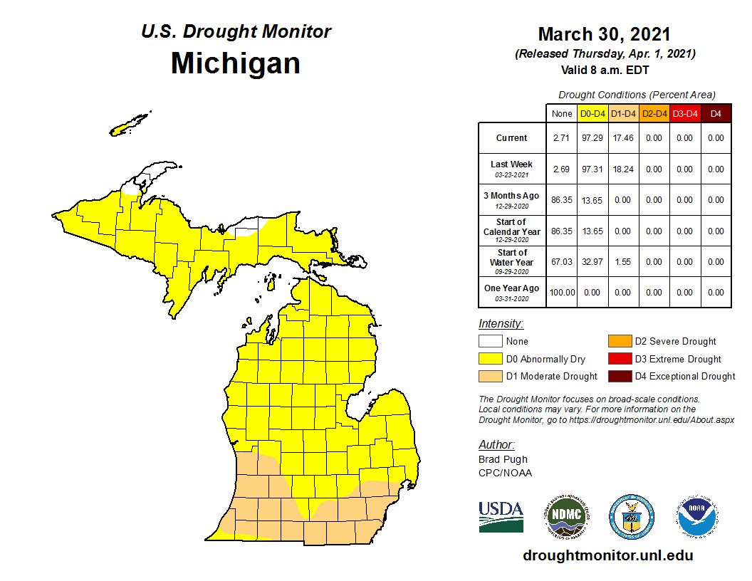
This is the updated drought graphic that came out yesterday which shows moderate drought conditions spreading across southern Michigan. Long-range CPC outlooks aren’t showing much improvement over the next couple of weeks.

The chart above shows the impacts of drought conditions by their color code on the map.
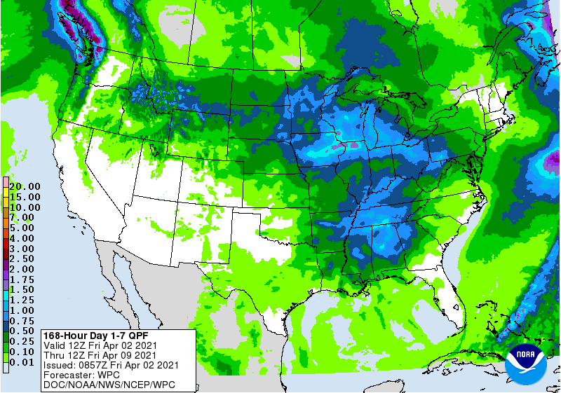
There are conflicting reports between the CPC and NOAA precipitation forecasts for next week. NWS models are still struggling with frontal boundaries for that period. Hopefully, rainfall predictions for next week hold true which shows we would see around an inch which would give us a good start for our monthly totals for April.
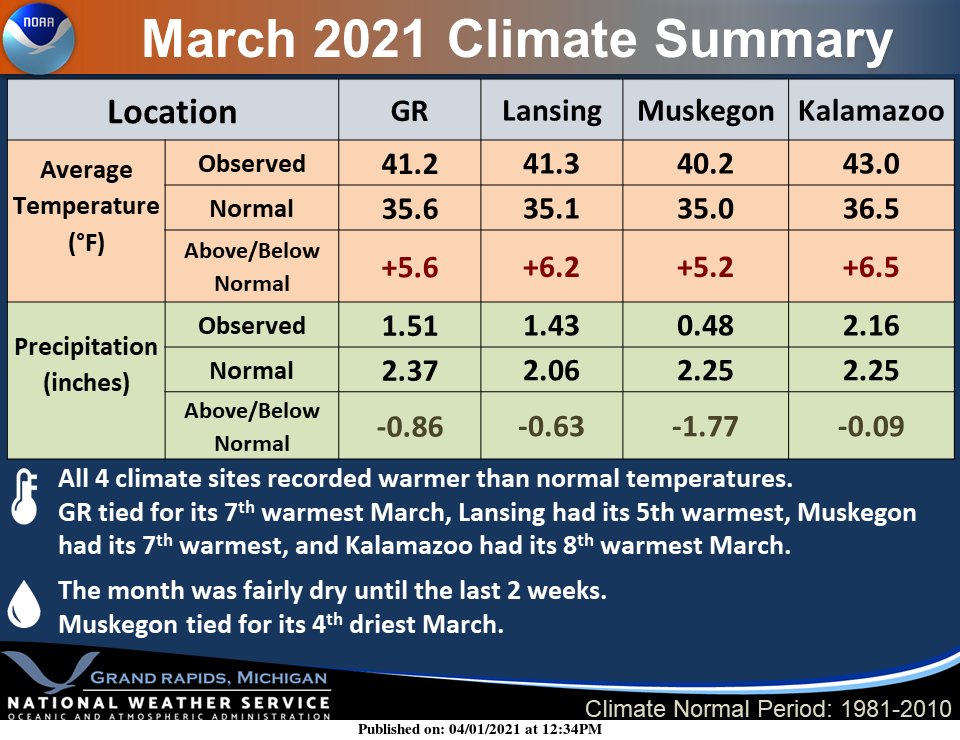 …and finally here is the summary for March…
--Dry with a warming trend this weekend--

Surface and upper ridging will provide full sun today, but it
will still be on the chilly side as MI is still on the wrn edge
of H8 thermal trough over the eastern conus. Winds today will be
much lighter than Thursday so blustery conditions not expected.
Mid level warm advection sends a batch of clouds through the
region tonight and early Saturday.

Southerly winds crank up late tonight and Saturday in tight
pressure gradient/return flow on back side of the departing sfc
ridge. Warm-up ensues and high temps on Saturday make a run at 60
inland from Lake Michigan. Deep mixing in wake of departing mid
clouds leads to gusty southwest winds of 30-35 mph.

Easter Sunday turns out to be a pleasant/warm day with highs near
70 and light winds although probably a bit less sunshine as high
level cloudiness impacts the region.

--Elevated fire danger, particularly Saturday--

Very dry air mass in place with sfc dew pts of 5-15 and PWATs only
around 0.1 leads to fire weather concerns for the holiday
weekend. We are still very much in pre green-up stage and dead
vegetation allows fires to spread out of control quickly/easily.
Afternoon relative humidities falling to 15-20 percent today and
30-35 percent Saturday and Sunday. Of particular concern is
Saturday when southwest winds will be strong/gusty.

--Potential for rain next week--

Confidence is still quite low regarding daily shower and tstm
potential (and frequency) for Monday through Thursday. However a
pattern conducive to locally heavy rainfall looks to eventually
set up nearby with a quasi stationary frontal boundary in the
vicinity and an upper low approaching from the west. Deterministic
and ensemble guidance still struggling with the specific details
and timing, and a Hudson Bay sfc high mid week could help push
the sfc boundary south of state and initiate the familiar dry
easterly flow.
The dew point here was 68 yesterday morning and by sunset, it was 38.
75 and sunny. Heading to the beach tomorrow.
Great Scotty had a low temp of 16* degrees this morning in my area happy January lol…INDY.
Drought?…with six consecutive days of rain next week?
The overnight low both here and officially at the airport was 16. Unless there is a surprise big April or May snow storm (it has happened in the past) Grand Rapids with 45.8” of snow so far this season will end up with the least amount of snow fall for a winter season since the winter of 1982/83. It will also be just the 2nd time since the winter of 1982/83 that less than 50” has fallen. And of the 45.8” that did fall this past winter 30.6” fell in February and of the 30.6” that fell in February 28.1”… Read more »
Impressive numbers from our 3 week Winter. Hard to believe it’s been 40 years since we’ve had this little snow. Thanks Slim!
I changed the snow fall total to the correct 45.8″ above
Slim
Crazy!! So basically, it was a one month winter! I’ll take a winter like this past one every year! The long spring comes back in full force this weekend!! BRING IT!!
https://weather.com/weather/tenday/l/b4ea0280869baa46799dc75eacef8904785ec43ad2f6fb098355fbc208a55e2c
Andy….
https://www.michigan.org/article/trip-idea/secret-morel-mushroom-hunting-michigan