
Our last decent rain was on the 11th when we had .56 of an inch and on the 6th when we had 1.53 inches, other than that we had two days with only a few 100ths. Today, tonight, and tomorrow give us our best chances of rain for the rest of the month with quarter to half-inch amounts mainly south of I96. Larger amounts could happen with any thunderstorms that may pop up.
Grand Rapids Forecast
9 26 grrKalamazoo Forecast
9 26 kzoU.S.A and Global Events for September 26th:
1898: A school teacher saved 32 children from death in Merritton, Ontario, when she spotted an approaching tornado and led her students to a safe corner. Unfortunately, falling debris killed one of the children and injured several others. Click HERE for more information.

1936: A forest fire burned several miles east of the town of Brandon, Oregon. The fire was far enough away that residents were not particularly worried. A sudden shift in the winds drove the flames westward and through town. The fire, caused by summer drought and fueled by the abundant Gorse Weed found in many of the empty spaces between buildings in Bandon, caused so much destruction that only a handful of structures were left standing when the fire finally died down. Click HERE for more information from the website, pediment.com
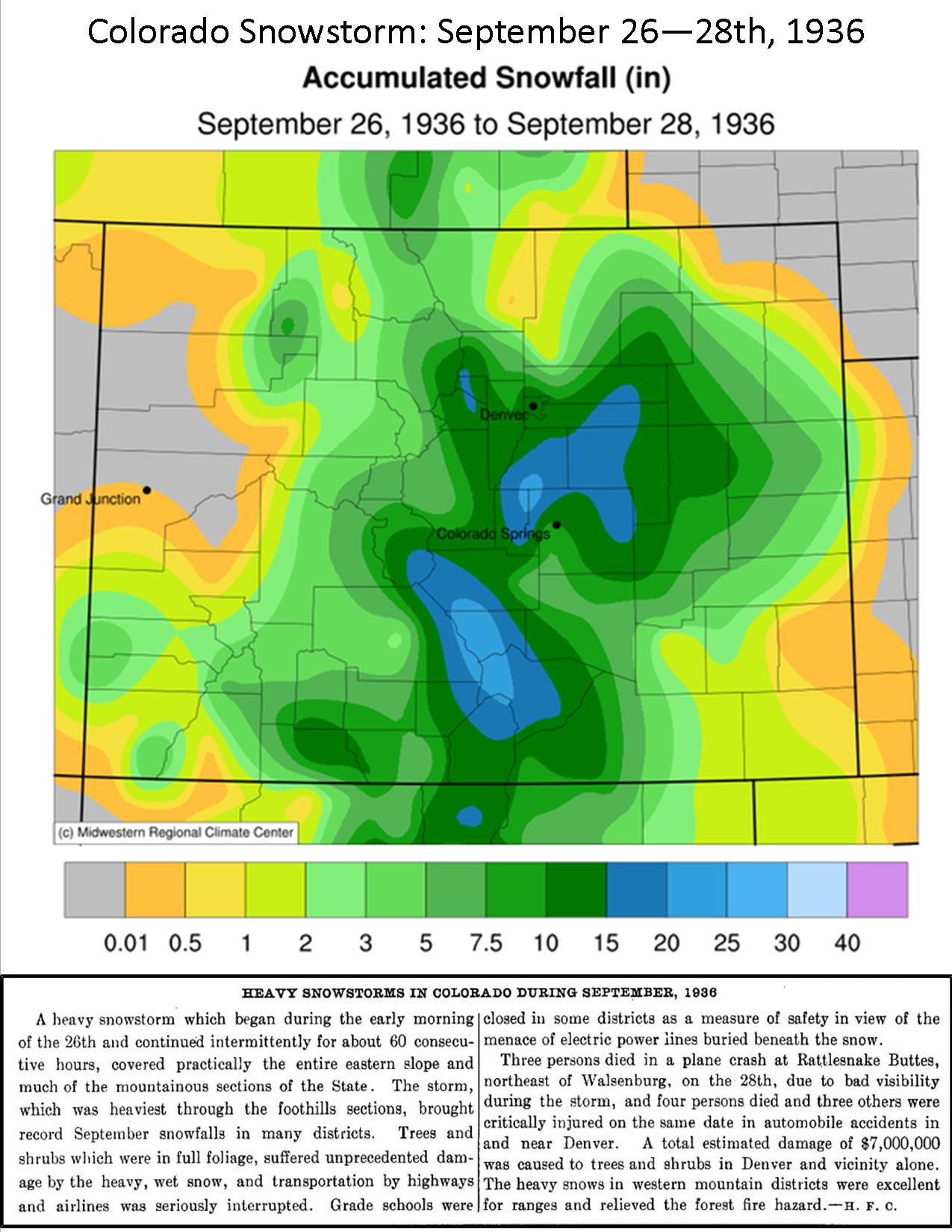
1936: The heaviest snowfall ever recorded in September and the heaviest snowfall ever recorded so early in the season dumped a total of 16.5 inches of snow on downtown Denver and 21.3 inches at Denver Municipal Airport. The 15.0 inches of snow measured from 6:00 PM on the 27th to 6:00 PM on the 28th is the greatest 24-hour snowfall ever recorded in September. This was the first snow of the season. The snow was intermittent on the 26th, but continuous from early afternoon on the 27th to around midnight on the 28th, except for a period of rain during the afternoon of the 28th.
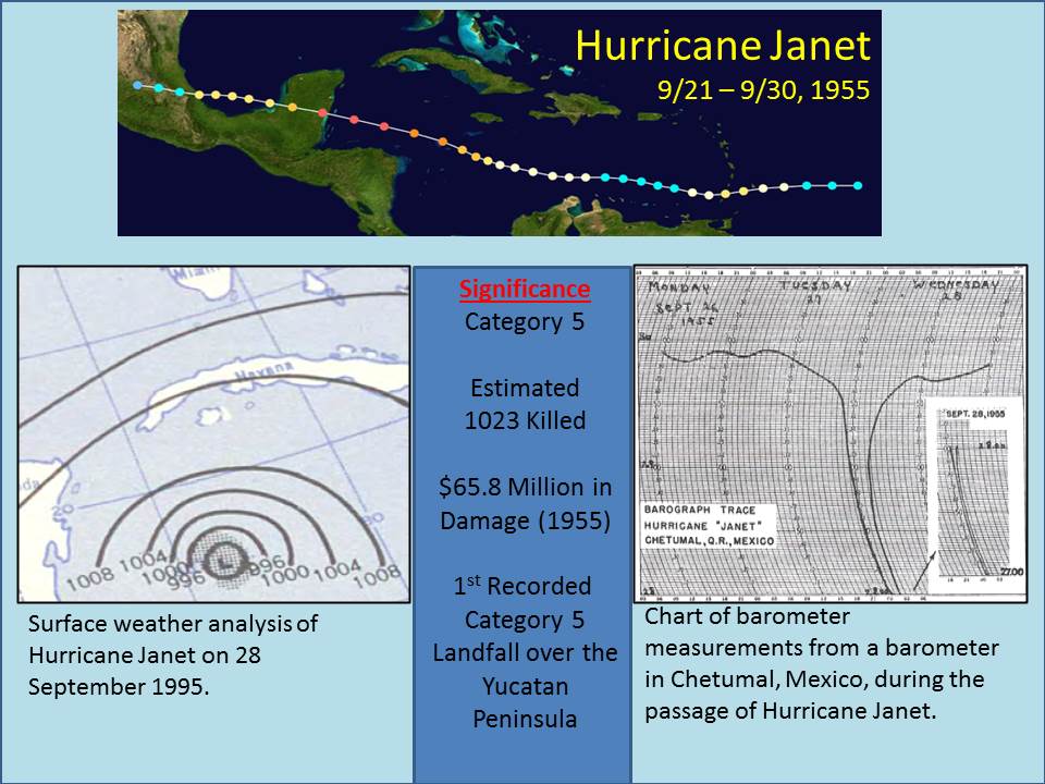
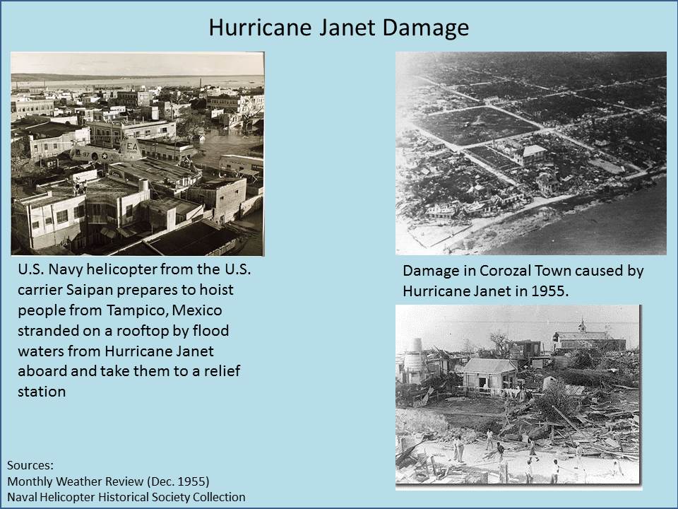
1955: On this date, the Atlantic reconnaissance aircraft, ”Snowcloud Five” went down while investigating Hurricane Janet and was never heard from again. Lt. Comdr. Windham with a crew of 8 and two newspapermen reported that they were about to begin penetrating the central core of the hurricane. Click HERE for more information from the Hurricane Research Division. Hurricane Janet made landfall at peak intensity near Chetumal, Mexico on September 29th. Janet’s landfall as a Category 5 hurricane on the Yucatán Peninsula was the first recorded instance that a storm of such intensity in the Atlantic made landfall on a continental mainland; prior to Janet, landfalls of Category 5 intensity were only known to have taken place on islands.
1971: Project Stormfury was an attempt to weaken tropical cyclones by flying aircraft into them and seeding with silver iodide. The project was run by the United States Government from 1962 to 1983. Hurricane Ginger in 1971 was the last hurricane Project Stormfury seeded.
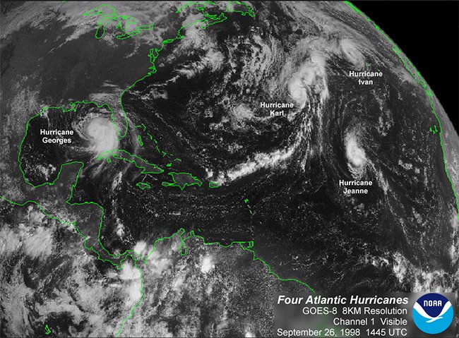
1998: There were four hurricanes were spinning simultaneously in the Atlantic basin: Georges, Ivan, Jeanne, and Karl. That was the first time this had happened since 1893. Click HERE for more information from The Weather Channel.
Forecast Discussion
The 00Z DTX sounding featured a 850-600mb saturated (hence, moist
adiabatic) layer. Isentropic ascent across the northwestern half of
Lower MI is strongly inferred given pronounced veering flow in the
lower troposphere per the DTX/APX 88D VWPs. Accordingly, we see
light showery precipitation extending from north of DTX to west of
APX. There is little if any reflection of this activity in the
surface observations; this is not surprising given the elevated
nature of this moist layer.

Models have been consistent with pivoting this isentropic lift
region southwestward into southwest Lower Michigan. Precipitation
coverage should really start to grow around or shortly after noon
today. Weak conditional instability // MUCAPE 500-1000 J per kg
// this afternoon will provide an environment marginally supportive
of thunderstorms. Although near surface forcing should be weak,
there may be some upper support. Specifically, there is a cutoff
low over the Quad Cities area and models suggest that a weak PV
extension from this feature could rotate north and overspread far
SW Lower MI this afternoon. As noted previously, hazards with any
thunderstorms that develop would chiefly be localized nuisance
flooding should cell training occur. Another "hazard" will be the
atypical, and potentially surprising, experience of thunderstorms
approaching from the southeast.

Conditional instability continues Tuesday night into Wednesday, so
continued precipitation chances are justified. However, the best
coupling of low level moisture with upper PV forcing is displaced
farther south; hence, thunder should remain south of I-96 and
perhaps even south of I-94.

Showers will be moving east of Lower Michigan on Thursday as a
transient rex block breaks down with the upper low moving east to be
replaced by upper ridging for Friday and the weekend. The pattern
transitions to an omega block across the CONUS as the western
longwave trough cuts off from a belt of stronger westerlies across
Canada. The upper low settles over Nevada with another upper
trough/cut off low along the mid-Atlantic coast and upper ridging
in between. Sensible weather will feature warm and dry conditions
under the upper ridge from Friday into early next week.
Keep that rain moving North! Bring it!
Weather FACT of the day. GR had a below normal temp summer despite the constant warm weather hype! Incredible!
Oh and I am BACK baby!!! I enjoyed my great summer! Now it’s time to get back into my regular posting for fall and winter!! LETS GO!!!
Thanks for the warning!
It’s been such a nice warm weather season with lots of sun! Since May, the only below average temp month was August (per Lansing records). September has been warm as well! Might as well keep this warm weather pattern going into fall and winter! I love short winters
Only 175 days til Spring!
It was a great warm season, but sunshine was 8% below average along with the wildfire smoke this summer. At least in Grand Rapids, maybe Lansing was sunnier
Ever since that 100% sunshine day that was reported at 40% something sunshine, I have my doubts with GR’s sunshine measurement as well.
Also Mookie I am very glad you use Lansing’s Weather Observations because they seem to be the most trustworthy, reliable and accurate in the area!
I also took a look at what the Grand Rapids location uses to get their observations and pictured below is what I have found. Maybe you could confirm this is accurate?
 ?v=1683978953
Lansing has no known issues like GR does. And yes, I believe that picture you sent is, indeed, where GR gets its data from 🙂
Lol!!!!
Very glad we’ve had a cooler summer, that means a nice flip to a beautiful warmer winter, with very little snowfall! Especially with the STRONG EL NINO moving in! It’s going to be nice to be able to keep up with the yard work throughout the winter! Also, keep doing what you can to keep that climate change going! It would be nice to have an Atlanta, GA type climate here in Kent County! Keep it ROCKIN!!
I love cool summers and remember all El Niño s are not created equal! This years El Niño = above normal snowfall and near normal temps! Bring it! Winter is the best!
New CPC looks bright red for winter with below average precipitation. I love it!
Saw that!! How could that be with all the cold weather propaganda and hype on here?!???? Bring on the STRONG EL NINO, with its wonderful warm temps and very little snowfall! The ski resorts should be getting prepared now to make sure they have tons and tons and tons of snow making machines because they’ll certainly need them this winter!!!
https://www.cpc.ncep.noaa.gov/products/predictions/long_range/seasonal.php?lead=3
Cancel ski season now?
I would! LOL!!
Will the rain hold together! We need some good rain! Bring it!
The weather here in Colorado has been just outstanding, not even a cloud since we arrived last Saturday. The days are hot out in the sun (we got sunburned yesterday) and the nights are crisp and cool. Love this dry air with dew points around 20.
Non weather for anyone interested in an update on our business:
https://www.hollandsentinel.com/story/business/2023/09/26/community-restaurant-hopes-to-reopen-before-the-new-year-in-zeeland/70959558007/
Glad to see it Barry! So happy to see small businesses like yours coming back after so many were forced to shut their doors and never reopen after the Lock Downs of 2020.
Thank God for the lockdowns or we would have lost millions of more lives due to the pandemic! As it was I lost an uncle and friends from this pandemic and would have been far worse!
Yeah right, my grandpa died of the flu & pneumonia in 2016 and we did not lock down anything at that time. Lock downs did nothing to save any lives.
https://www.abcactionnews.com/news/national/coronavirus/johns-hopkins-university-study-finds-lockdowns-only-reduced-covid-deaths-by-0-2
Read it and weep and do some critical thinking this, article is based on peer reviewed studies. On top of this lock downs caused a massive spike in suicides, drug addiction, loss of education, chronic depression, poverty and a loss of critical programs that fed impoverished students. YOU DON’T LOCKDOWN HEALTHY WORKING CLASS PEOPLE!!!!!
With people dying by the thousands and with a deadly unknown airborne virus spreading, the lockdowns were a very smart decision! Great decisions at the time! Arm chair quarterbacking is worthless! Rock on! Bring on winter and let’s see a lot of monster snowstorms!
Knee jerk reactions with zero scientific basis, that do no good and have zero effect on curbing the disease are worthless. Never has anyone suggested or even thought of locking down healthy individuals. You quarantine the sick and the vulnerable like has been done for millennia!! Locking down healthy individuals and businesses was one of the dumbest decisions in the history of mankind!
Lol!
So again Barry, back to my point, I am very glad that GOD has blessed you and your business has survived worthless economic killing lockdowns and a fire and you will be back providing a wonderful spot for your customers again! May GOD continue to bless you, your family, and your customers with many, many years of economic success!!
The mean for September at Grand Rapids is 64.9. At Lansing 65.1 at Holland 65.0. All locations are above average. The highest reading this month is 91 there have been 3 days of 90 or better. For the summer season there has been 14 that is +4 for the year. There has been 1.23” of rain fall that is -1.61. For the year there has been 27.65 that is -1.56. There have been 66 HDD’s for September and for the season 80 that is a departure of -18. There have been 72 CDD’s this month so far that is +5… Read more »
The official H/L yesterday was 69/54 there was no rain fall, Here in MBY there was a trace. There were 3 HDD’s and no CDD’s The sun was out 28% of the time. For today the average H/L is 70/49 the record high of 92 was set in 2017 and the record low of 30 was set in 1947. The record rain fall amount of 2.27” fell in 1915. Last year the H/L was 57/49 and there was 0.02” of rain fall.
Slim