We had 2.5 inches of liquid precipitation for December and 5.2 inches of snow, if we include November we have a snowfall total of 13.1 inches.
Our biggest snowfall last year was on February 16 when we had 5.5 inches. In 2020 the biggest snowfall was 8 inches on 1/20. Big snowstorms have been few and far between the past few years.
We had 3 inches of snow overnight which brings us to 16.1 inches for the season (including November).
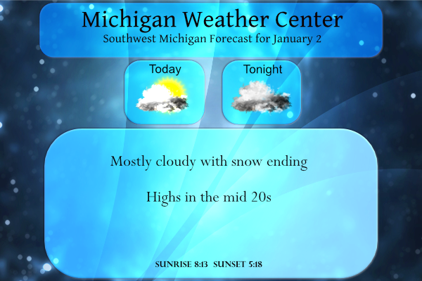
Yesterday’s high temperature was 36.5° and the low was 20.5°, it is currently 18° at 6:30 am.
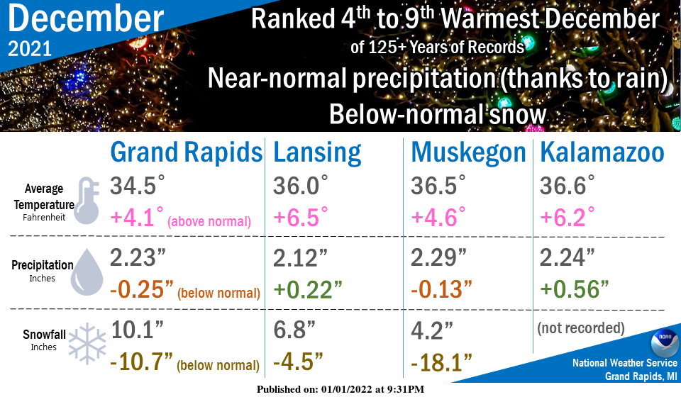
It was easily a Top 10 Warmest December for the area out of about 125 years of records, the warmest December since the record-breaking 2015. We have not had a snowier-than-normal or colder-than-normal December since 2017.
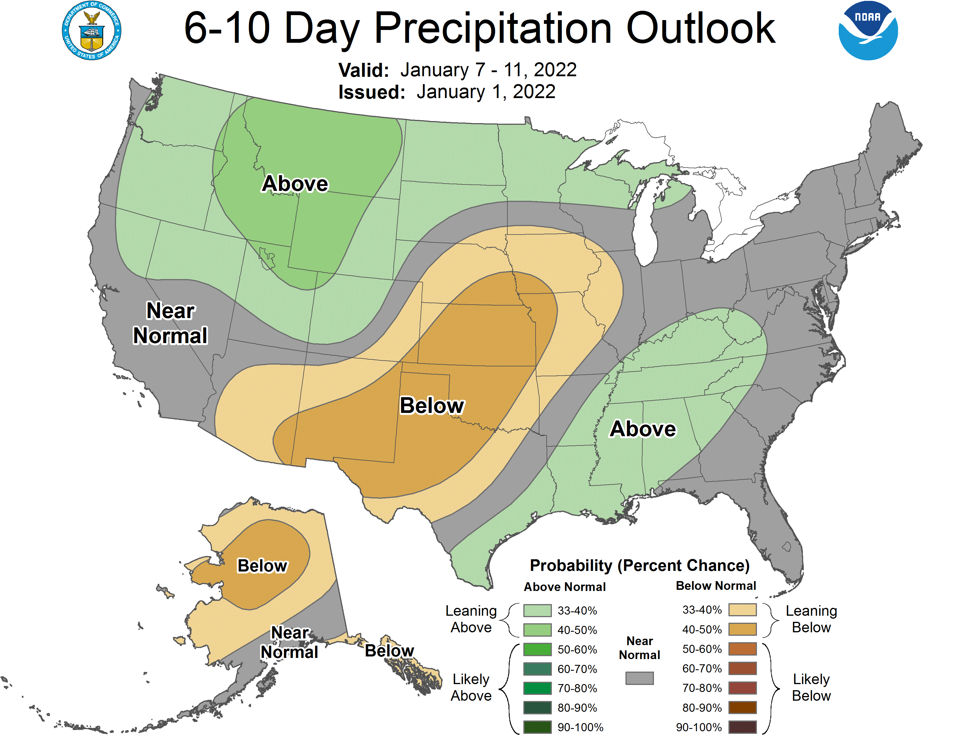
For what it is worth below are the 6 to 10-day outlooks from the CPC:
[columns] [span6]

[/span6][span6]
[/span6][/columns]
Forecast Discussion
--Synoptic Snow Ends Early; Period of Lake Effect--

System has put down around 2-4" so far with SLR of around 14:1
observed at the GRR NWS office. Up to another inch of accumulation
is still possible through daybreak where mesoscale banding
persists, otherwise light synoptic snow shutting down abruptly
with arrival of much drier air from the north behind the departing
wave. We should be able to expire winter weather advisory as
scheduled at 7 am unless enhanced banding hangs on a bit longer.

The drier air coming in should also allow for at least a period
sunshine today, before lake clouds pour back into western
sections.

CAMs are similar in showing a narrow lake effect band in
northerly flow coming onshore at Ludington/Pentwater mid to late
morning. This band may provide a decent burst of snow with a
quick local inch or two, aided by a secondary shortwave coming in
from the northwest. The band could also eventually impact the rest
of the lakeshore south of Pentwater this afternoon, however a
weakening trend in lake effect is expected after 18Z with arrival
of subsidence/NVA. Inversion heights in fcst soundings at South
Haven are only around 4K this afternoon, so only light local
accums expected.

Quiet and dry weather, and even some sunshine, is expected for
Monday and Tuesday with zonal flow and dry warm advection pattern
in place. It will be breezy as well with gusts around 25 mph.

--Cold with Occasional Lake Effect Wednesday Through Friday--

A more active pattern returns for mid to late week as upper
trough is carved out over the GrtLks Rgn and cold H8 air of minus
15C to minus 18C returns behind a deepening sfc low which tracks
from WI across the Straits then into Quebec. The winds on the back
side of that low on Wednesday could become quite strong/gusty,
with EC ensemble guidance suggesting gusts near 50 mph are possible
along the lakeshore and around 40 mph inland.

The combination of lake effect snow/blowing snow and falling
temps behind the cold front could lead to a period of hazardous
travel Wednesday through Friday with some accumulations likely
mainly near/west of Hwy 131.
5.2 inches on my car on the driveway. The airport (about 2 miles away) reported 5.7. Perhaps some snow melted on impact or blew off from the light wind, but pretty close to the airport total.
I see 2-5″ reports from one end of the state to the other, which is what the NWS forecasted. We received 2″ maybe 3″. Hard to get an accurate measurement because of the drifting. There are areas in our driveway and back deck with no snow at all. It is pretty out, though.
On the other hand, Cook County and its surrounding areas were under a Winter Storm Warning. However, I only see reports of 2-4″, with one report of 6″. Kudos to NWS GR for their restraint.
Here you go Mark. The second picture down shows the MI 24 hour snow totals. It shows a nice stripe of 4 to 6 inches from GR to Lansing, including Lansing. It also shows a lot of the Chicago area picked up 6 to 8 inches and the SW part of Mi towards Kalamazoo/Allegan picked up less than GR, even though they supposed to get more than us! Incredible!
https://www.weatherstreet.com/weather-forecast/michigan-snow-cover.htm
I was looking at the NWS. Your link appears to show snow cover, not snowfall reports from this event – unless I’m reading the heading incorrectly.
The first picture shows the current snow cover and the second one shows total snow accumulation over the last 24 hours!
There is an ad covering the second pic that will not clear. But thanks for trying to share. 😬
The official storm total for Lansing was 4.4 inches, right in line with my comment from last night that Lansing would get 4 to 5 inches! The RDB model rocks and is the most accurate model out there! Incredible!
5.3 inches of snow now on the ground out in my area we received 4.4 inches overnight and by the looks things later this week many areas in west Michigan will have over a foot of snow on the grounds when the next storm blows in who knew??? InDY
Who would have thought and skiing here I come!
Nice December graphic. Boy the lake shore areas were really low with the snow totals, almost 20 inches below. Odd trend the past several years of almost no lake effect snow, especially in December.
Looks like a great week of winter weather coming up! Don’t worry the warm weather fanatics will tell you no big deal! I expect decent accumulating snow, wind and cold on Wednesday afternoon/evening! Get ready and Rock n Roll will never die!
Here at my house I recorded 4.4″ of snow fall yesterday and overnight. There is now 4.2″ of snow on the ground. With clear skies it has now dropped down to 16 and that is the overnight low here so far.
Slim
Sounds great and that fits in with the predicted 3 to 5 inches! Incredible!
Historical Daily snowfall records! Many of the warm weather fanatics on here always say, the storm was no big deal and if a storm does not give you 8 or more inches it must be no big deal! How wrong could they be? Many of the GR historical daily snowfall records are around 5 to 6 inches! Just look at yesterday for example! The record was 5.9 inches of snow, so yes a storm total of around 5 inches is a big storm! I love how the facts always dispute the warm weather fanatics fantasies! Incredible!
That is true. For the most part southern lower Michigan does not have very many big snow storms. In fact more than half of the snow Grand Rapids receives is lake effect. So if not for the lake Grand Rapids would average around the 42″ that Madison, WI has.
Slim
Lets just say I love long Winters lol…InDY
Yes and winter this year may last well into March or even April! I love it!
What a great storm! The RDB nailed another one! As of midnight last night GR had already picked up 3.9 inches of snow, so their storm total should end up around 5 inches! Fantastic!