Yesterday was a great day for snow cleanup or enjoying outside winter activities such as skiing out at Bittersweet (they were packed yesterday). I got to use my snowblower for the first time this season.
Yesterday’s high was 24° and the low 17°. We currently have 19° at 8 am.
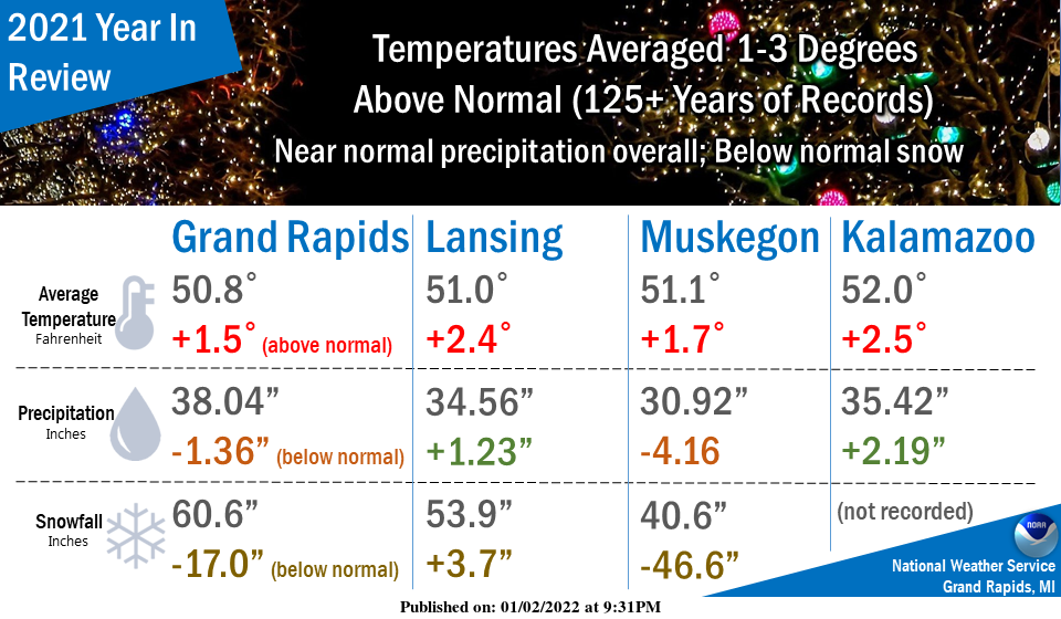
2021 will be remembered for being slightly milder than usual, with below-normal snowfall and near-normal precipitation. Temperatures averaged around 1 to 3 degrees above normal across our area. Precipitation was quite variable but averaged close to normal for the year. Snowfall averaged below normal for most of our area.
Forecast Discussion
The main focus this week is a period of potentially significant
lake effect snows, something we`ve not had much of yet this
winter, for Wednesday through early Friday. Wednesday and
Wednesday night looks to feature a combination of hazards
including snow showers/squalls, blowing snow, high winds, and
falling temperatures/wind chills. Travel could be greatly impacted
during this time due to the potential for whiteouts and icy
roadways. Then for Thursday and Thursday night the concern becomes
the potential for a dominant LES band which could bring localized
heavy snow amounts at the Lake Michigan shoreline.

Good model consistency regarding the track, timing and strength of
the system on Wednesday. Sfc low associated with evolving/digging
upper trough deepens and occludes as it slowly tracks across the
Straits of Mackinac. As this is occurring, cold Arctic air is
pulled around the south side of the system into srn Lwr MI from
the west/southwest. By the end of the day, we end up with sfc
temps ranging from the teens along the I-94 corridor to near 30
over nrn Lwr MI.

This temp contrast should enhance low level convergence/FGEN
during a period when deep moisture associated with the upper
trough will be present Wed afternoon and evening. During this time
the predominant low level flow is progged to be out of the west-
southwest which favors a large portion of wrn Lwr MI for
significant snow showers/squalls. The strong winds (sustained
around 20 mph with gusts over 40 mph) should carry the snow bands
quite a distance inland.

Later Wednesday night into early Thursday as the low pulls away,
a sfc trough drops through and shifts the winds west/northwest
and the speeds drop off. Also during this time the deeper
moisture is shown to lift out with an inversion strengthening
around 5K ft, so intensity should drop off a bit going into early
Thursday.

First crack at potential snow accumulations for Wednesday and
Wednesday night is for 4-8" for much of wrn Lwr MI, with amounts
tapering off considerably east of a BTL to Ionia to Evart line.
The GRR area and US 131 corridor north from GRR may be favored for
the highest amounts if the strong WSW flow regime stands.

Interesting set up for Thursday/Thursday night as low level flow
goes more northerly but ideal lake effect conditions continue with
upper troughing/cold air still present. Models are keying on a
dominant convergence band although the low level flow is unclear
as it hinges on potential synoptic system passing by to our south.
A more northerly flow as advertised by the ECMWF would favor big
snows staying offshore of wrn lwr MI, whereas the more NW flow
shown by the GFS would favor the shoreline for additional
accumulation, possibly heavy. If it does stay offshore Thursday
night, the band should still come onshore Friday morning in wrn
Lwr MI before weakening Friday afternoon.
Get prepared now! It is going to be wild!
Check this out!
https://www.weather.gov/grr/weatherstory
Hello Muskegon!
http://wxcaster.com/gis-gfs-snow-overlays.php?STATIONID=GRR
With west winds a lot of that snow will be blowing inland wow to the wow …INDY
Let’s hope so!
Blizzard conditions coming Wednesday into Thursday most places in west Michigan will have a foot or more of snow on the ground by Friday yes its going to be a wild ride is right….InDY
Sounds good to me! Bring it!
The 5 day snow map for this week is looking promising! Also if this event plays out with all the ingredients coming together these totals look low! Cold air, unstable air, moisture levels rising, WSW wind 20 to 40 MPH and warmer than normal lake MI water temps! Incredible!
http://wxcaster.com/gis-gfs-snow-overlays.php?STATIONID=GRR
It’s hard to believe that Lake Michigan water temps are mid 40s in January. Could be some serious LES later this week.
+1
Great winter weather weekend and now more of the same all week! Watch out for the event on Wednesday! It is going to be big and wild! Get prepared now!
It is now official that going back to 1899 (when complete 12 month records are available) that 2021 with a mean of 50.8 at Grand Rapids was the 8th warmest on record. With a mean of 51.1 it was the 3rd warmest at Muskegon and it was the 4th warmest at Lansing. There is too much missing data to come up with the ranking at Kalamazoo. It looks like the official overnight low at GRR was 13. Here at my house the overnight low was 16 that 16 is the current official reading at GRR here at my house with… Read more »