 We have have been lucky thus far this winter with the lack of synoptic snow events as most of our snow has been from clipper systems. The cold air and lack of moisture, and a mainly north wind has limited lake effect but had built up a snow base over a few weeks rather than all at once inland.
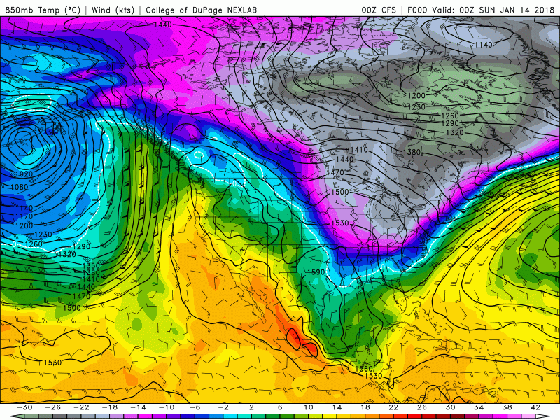
When the jet has moved north we have seen mainly rain but I wonder as we reach the second half of winter if we will see a transition to a more active jet moving northward. I am not seeing an extended period of Arctic air as we saw in December – early January but we will see the temperatures going back and forth over the next couple weeks more above normal than not.
Lake effect snow showers will impact the shoreline again today, before a more widespread light snow develops tonight and continues on Monday. Most locations will see an inch or so tonight and another inch or two on Monday. The Monday morning commute could feature slick conditions. We will probably see an advisory in place later today.
Additional snow showers are expected Monday night and Tuesday, with the potential for several inches of lake effect snow around South Haven. Cold air will stay with us through midweek then a warmup will occur toward the end of the week with highs next weekend up around 40 thus the beginning of another snow melt.
A pattern shift occurs Wednesday night and this should last into next weekend. The upper flow becomes more zonal, with surface high pressure centered over the Tennessee Valley Thursday. This high moves to the Carolinas by Friday night. This brings a SW low level flow over the Great Lakes region and H8 air around 0C pushes in. The models are in much better agreement on this as compared to last night`s runs.
Daily high temps should moderate each day in this set up, warming from the low 20s Wednesday, to around 40 by Saturday. For the most it looks dry in this period too, until perhaps Saturday when we see a cold front move into the upper Midwest. This may bring some rain, possibly mixed with snow north. Even higher chances of rain should move in early next week as the front arrives. Cold air and a change back to snow appears to not occur until Sunday night.
Today: Mostly sunny, with a high near 20. Wind chill values as low as -1. South wind 5 to 10 mph.
Tonight: Snow, mainly after 10pm. Low around 15. South southeast wind 9 to 11 mph. Chance of precipitation is 100%. New snow accumulation of around an inch possible.
M.L.King Day: Snow. High near 24. Southeast wind 7 to 10 mph. Chance of precipitation is 80%. New snow accumulation of around 2 inches.
Monday Night: A 50 percent chance of snow. Cloudy, with a low around 13. South wind around 6 mph becoming north in the evening.
Tuesday: A chance of snow before 1pm, then a chance of snow showers after 1pm. Mostly cloudy, with a high near 21. West wind around 7 mph. Chance of precipitation is 30%.
Tuesday Night: A 50 percent chance of snow. Mostly cloudy, with a low around 10.
Wednesday: A 50 percent chance of snow. Mostly cloudy, with a high near 24.
Wednesday Night: A slight chance of snow before 1am. Mostly cloudy, with a low around 15.
Thursday: Mostly sunny, with a high near 29.
Thursday Night: Partly cloudy, with a low around 22.
Friday: Mostly sunny, with a high near 36.
Friday Night: Mostly cloudy, with a low around 29.
Saturday: A slight chance of rain. Mostly cloudy, with a high near 41.
I’m OUTTA My HEAD ….On Monday MOANIN…..
Spin()()– Jimmy Buffett – Come Monday (HQ with lyrics) – YouTube
https://www.youtube.com/watch?v=qnKKlf_FGwg
GREAT SONG!!
CUE:;:;::; Steve Earle – Copperhead Road – YouTube
https://www.youtube.com/watch?v=xvaEJzoaYZk
+1
Tick Tock…LOOK at The CLOOCK…
IT’S ….Almost……………………
“MOANDAY”….UGH
Stay CUED……
Very LITE….Sugar Snow…..Right NOW
@ The YARDofCUES
Stop the dramatics. The upcoming pattern is neither extreme warmth or non-stop snowstorms. It is looking like an up-and-down pattern. Much more active for areas of the Midwest that haven’t seen much precip. I think we will be seeing lots of rain AND snow in the weeks to come. Probably many systems that start as rain and then change to snow. Of course, as a snow-lover, I am hoping to be on the colder side of many of these systems… 😛
I’m liking the look of that nice WARM weekend coming up!
http://wx.woodtv.com/weather/8forecast_640x480.jpg
I agree with you, that is a definite warm up and warmer than I was thinking for this coming weekend. Hopefully they are dead wrong, because that will evaporate the snow from this week!
A moderate band of SNOW is heading right at us! ROCK n ROLL will never die!
http://woodtv.com/weather/satrad/
Back to the facts, the temps keep getting WARMER & WARMER with each run!! Good, that will get rid of those ugly snow piles at the end of the driveway! I have 95 percent grass in my yard now, 5 percent small snow piles at the end of the driveway that needs to go!
https://weather.com/weather/tenday/l/USMI0344:1:US
Move this band South about 75 miles and BAM 2 feet of SNOW! A storm is a brewing baby!
http://www.pivotalweather.com/model.php?m=gfs&p=snku_acc&rh=2018011418&fh=240&r=conus&dpdt=
WINTER WEATHER FACT!!
GR is currently above normal for seasonal snowfall and we are currently in a WWA for more SNOW! How is that possible? What a winter!!!
WWA for 2 inches of snow??? What is this Texas??
The only current facts worth talking about are the fact that the ground is bare, and the fact that we are behind last years total snowfall, and last year ended up well below normal snowfall. And you could throw in the fact that we haven’t had a major snow storm in many years now, not since the groundhog day blizzard.
Your last statement is a blatant lie! We have had multiple major snowstorms since the groundhog day blizzard!
Look it up. The last blizzard warning we had was indeed the Groundhog Day blizzard. That was the last major shut down snowstorm we have had.
I guess it depends on your definition of a major snowstorm. We have had many like this since 2011!
http://woodtv.com/2016/02/23/mid-week-snow-storm/
A major snow storm is one that would be classified as a blizzard. The last blizzard warning we had was the groundhog daynone. You can search them here
https://mesonet.agron.iastate.edu/request/gis/watchwarn.phtml
Our definitions of a major snowstorm are 100% totally different. You are describing an event that only happens about once every 10 to 15 years! Not a surprise that we have not had one of those in the last few years! On the contrary very typical!
Nice 10 day SNOW map and a storm is brewing. Check out Central and Northern Lower MI! With all the warm weather talk on this blog you would think that it would never snow again the rest of this winter??
http://www.instantweathermaps.com/GFS-php/conussfc.php?run=2018011418&time=PER&var=ASNOWI&hour=384
Only 6 or 7 inches of snow in my area for the nexts 16 days?? I’ll take that! Especially with the weekend WARM ups coming up, that will melt in no time!
WWA – bring it!!
http://wxcaster.com/gis-gfs-snow-overlays2.php?STATIONID=GRR
Climatology for today January 14th At Grand Rapids, MI
The average H/L is 31/18
The record high is 53° in 1928 the coldest maximum is 7 in 1929
The record low is -13° set in 2015 the warmest minimum is 44 in 1929
The most snow fall is 7.2” in 1963
The most on the ground is 22” in 1979
Last year the H/L was 31/18 and there was no snow on the ground.
Slim
We will be leaving for Florida on Tuesday for our cruise. I should be able to post from the motels Tuesday, Wednesday, Thursday, Friday and Saturday morning. But from Saturday morning (the 20th) until at least Saturday night the 27th I will not be able to post.
Slim
Have a great trip Slim!
Have a fantantastic trip Slim! Make sure you bring the WARM weather back with you!
Have a great time!! Enjoy the warmer temps & sunshine!
Picked up 4.5 inches of snow in less than 4 hours this morning with the Lake Convergence band that moved through on a southerly wind. It was coming down hard…and beautiful!
Wow that was a nice event for you! Of course here in GR we did not get much more that a few flurries
Slim
No precipitation here, but lots of sunshine.
Sure was, Slim. 🙂 The South-wind enhanced events are very localized and unique to this area…and often not discussed much by local mets. Many people in the rest of Michigan don’t even know they’re occurring because it happens over our little curve of the lake. Pretty much the heaviest snowfall I see here every winter comes from these enhanced/convergence bands that creep up on us from the lake. Often times, the NWS doesn’t even know the impact they are creating (but that’s because they’re tough to forecast) One of the meteorological phenomena I love. Then, pretty much right after it… Read more »
WOW!! We had sunshine & very cold temps.
+1
What I am liking is the WARM up on the weekend, then we stay at or ABOVE normal temperature wise after that, no more of this high temps in the teens BS!
https://weather.com/weather/tenday/l/USMI0344:1:US
Now that we have reached about the midpoint of Winter, one has to wonder if we will go yet another year without a major Winter storm? We are coming up on the 7 or 8 year anniversary of our last big snow storm, and there has not been one since. With nothing but light snow and warmups in the forecasts, it could be a while before we get the next one.
I know Barry, that is true. Without the snow pack in place the warm-ups can really flourish as we’ve seen the past couple of years. Now that the lake has really cooled down too, the lake effect will diminish as well.