...WINTER WEATHER ADVISORY REMAINS IN EFFECT UNTIL 7 PM EST
TUESDAY...

* WHAT...Snow. Additional snow accumulations of 3 to 5 inches.

* WHERE...Ottawa, Allegan and Van Buren counties.

* WHEN...Until 7 PM EST Tuesday.
...WINTER WEATHER ADVISORY REMAINS IN EFFECT UNTIL 11 PM EST THIS
EVENING...

* WHAT...Snow. Additional snow accumulations of 2 to 4 inches.

* WHERE...Mason, Oceana and Muskegon counties.

* WHEN...Until 11 PM EST this evening.

* IMPACTS...Plan on slippery road conditions. The hazardous
  conditions could impact the morning or evening commute.
...WINTER WEATHER ADVISORY IN EFFECT FROM 7 AM THIS MORNING TO
7 PM EST THIS EVENING...

* WHAT...Snow expected. Total snow accumulations of 2 to 4
  inches.

* WHERE...Shiawassee, Genesee, Lapeer, St. Clair, Livingston,
  Oakland, Macomb, Washtenaw and Wayne Counties.

* WHEN...From 7 AM this morning to 7 PM EST this evening.
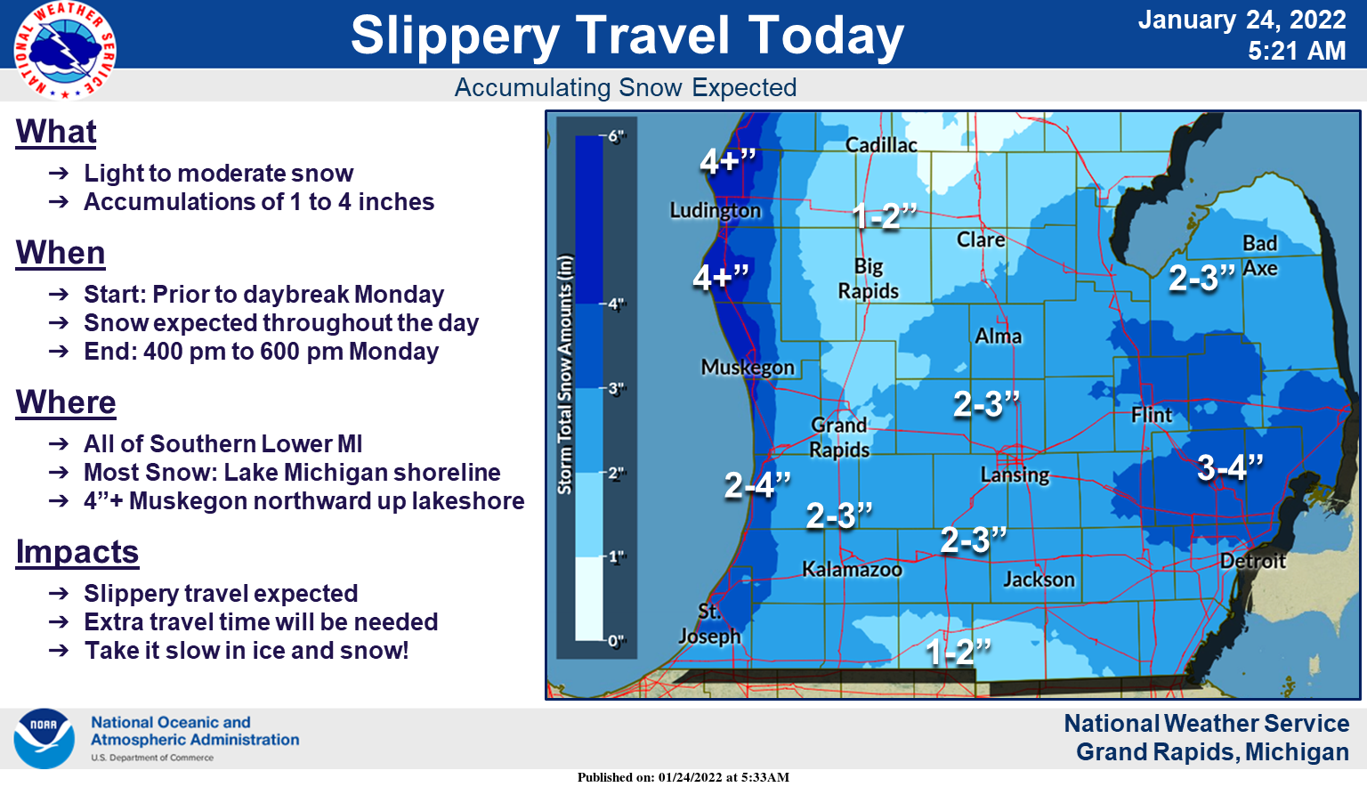
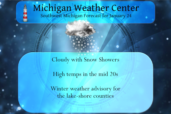
A low-pressure system will slide through Lower Michigan today bringing widespread accumulating snow. The snow will accumulate in most areas to 1 to 4 inches by evening. The highest totals of around 4 inches will occur from Muskegon north up the lakeshore to Ludington. Expect slippery travel today due to the falling snow, so allow extra travel time to reach your destination. High temperatures will hold in the 20s today for highs.
Yesterday’s high was 24° and the low 16°, we had a synoptic snow event which gave us 4.5 inches which ended in the early morning giving way to mostly sunny skies. We have had 14.7 inches of snow so far this month and 27.8 inches for the season. With another six weeks or so of winter, it is conceivable we should surpass our total of 40 inches from last year. The CPC guesses at this time look promising if you are a snow lover with cooler than normal temps into the first week of February and normal to above-normal precip predicted.
Forecast Discussion
- Another Clipper today with lake enhanced snow showers

The northwesterly flow will allow for lake enhanced snow this
morning with the highest snowfall along the lakeshore with 4 to 6
inches possible, especially in our northwest counties. The snow
bands will overspread the region with a widespread 1 to 2 inches
today with locally heavier amounts up to 3 inches possible.
Snowfall outside of the lakeshore counties will be below advisory
criteria.

The big question today will be how widespread snow showers will
be and what will it amount to. While the isentropic lift will
occur this morning due to the promulgation of a low level jet
through the region, it will be strongest through the eastern
portion of southern lower Michigan, east of the 127 corridor.

As the mid to upper level trough deepens and elongates over the
area, downsloping flow with dry arctic air will settle over
central lower Michigan and the 127 corridor. This will dampen
snowfall amounts. The lift and moisture will be better through
eastern lower Michigan due to the previously mentioned low level
jet and the southwesterly flow. So expecting 1 to 2 inches with
locally higher amounts up the 3 inches through the day through
central lower Michigan and 4 to 6 inches along the lakeshore.

- A Cold week ahead with snow on Thursday

A quasi stationary upper level low situated over the Hudson Bay
continues to dominate the weather pattern through this week. This
rotating low will keep persistent cold air filtering into the
lower peninsula of Michigan. The northerly flow coupled with the
cold mid level air and persistent instability will create lake
effect snow showers Tuesday into Wednesday. 850mb temps this week
will range from -12C to -20C over the region which will keep max
daytime temperatures in the teens through midweek.

 While there will be a slight warm up into the mid to upper 20s
through the latter half of the week, this will only be a precursor
to another trough that will swing through the region Thursday into
Friday with another shot of cold arctic air into the weekend.
We are in a great temperature pattern! Keep it rocking!
Great news>>>>the last CPC outlooks show above normal snowfall on the way! Get ready to rock n roll! Winter is the best!
The snow just keeps coming! Wow!
http://wxcaster.com/gis-gfs-snow-overlays.php?STATIONID=GRR
It looks like it was another Bingo for the RDB model! The most accurate model on the market! Incredible!
We picked up 2.5” or so. It looks like the bulk of the storm went south again. But, I am also surprised by the lack of a WWA.
I hope we catch up to our normal yearly snowfall! Michigan looks best when there’s a fresh coating of snow on the trees.
Rock on and who wouldn’t want cold and snow in West Mi this time of year!
I just cleared the driveway of 1.5″ of light fluffy snow. There is now 6.8″ of total snow on the ground here.
Slim
Over a 110 hours since temperatures felt above freezing we are in such a freezer box out there …Who knew?? InDY
Here is some information on that reported -30 or -31 in West Virginia. Located just 125 miles west of Washington, the temperature at a weather station in Canaan Valley plunged to minus-31 degrees. It is the coldest reading on record in that part of the state. The weather station is managed by Virginia Tech at the Canaan Valley National Wildlife Refuge. The station is at the northern end of the valley at an altitude of 3,150 feet. Canaan Valley is shaped like a huge bathtub with only one exit where the Blackwater River leaves the valley flowing west toward the… Read more »
Thanks. I just learned something today.
Let it snow let it snow it snow ….Who said snow drought??? Lol….InDY
We are still getting hammered with snow! What a storm!
From Bill’s Blog today, “A state record low temperature of -30.2 was set last week at Canaan Valley, West Virginia.”
Wow, West Virginia!
Huh?
That is even too cold for me! I am happy with temps in the teens!
That is very cold but -37 on Dec. 30, 1917 in Lewisburg is the state record low for West Virginia
Slim
Clearly an epic fail but the NWS. Last night and this morning the NWS said one inch of snow for GR and no WWA! I am not sure what modeling and data they are looking at! Clearly not the RDB model. In looking at the moisture content and lift and now the radar, they are 100%wrong! Last night the RDB showed GR picking up 2 to 3 inches! We already have one inch and the road conditions are hazardous! Clearly a WWA should be issued! Is a WWA used to alert the public of hazardous winter conditions? Incredible!
Once again we are getting pummeled with snow! Fantastic winter!
So far there has been 0.7″ of new snow fall here. And there is now 6.5″ of snow on the ground. At this time with light snow falling it is 17.
Slim
What? More cold and snow! Who would have thought? What a winter! Amazing stretch of cold weather and no change in sight! Absolutely incredible winter weather! Get outside and enjoy!