Winter will hold firm in the days ahead, with cold overnight lows in the single digits and daytime highs in the teens to around 20°. Lakeshore areas will see lake-effect snow showers through Wednesday, then again on Friday. Most areas will also see a chance of snow on Thursday. This is the climatologically coldest time of year, and February is just around the corner. The CPC is still guessing chances of above-normal precipitation right on into February with normal to slightly above normal temperatures which should give us plenty of snow if it plays out.
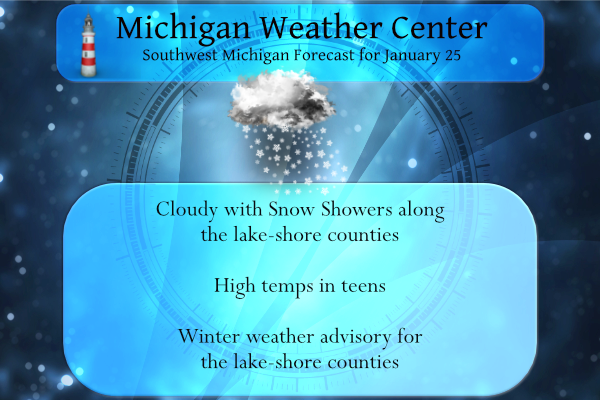
Lake effect snow will continue today, tonight and into Wednesday morning. 2 to 6 inches of new snow is expected in portions of the lakeshore counties from this morning through Wednesday morning. Highs today will only top out in the teens with wind chills near zero F. Wind chill values will be even colder tonight dipping into the -5 to -15 F range.
Yesterday’s high here in Otsego was 27° and the low was 17°. With yesterday’s snowfall, we are up to 16.9 inches for the month and 30 inches for the season.
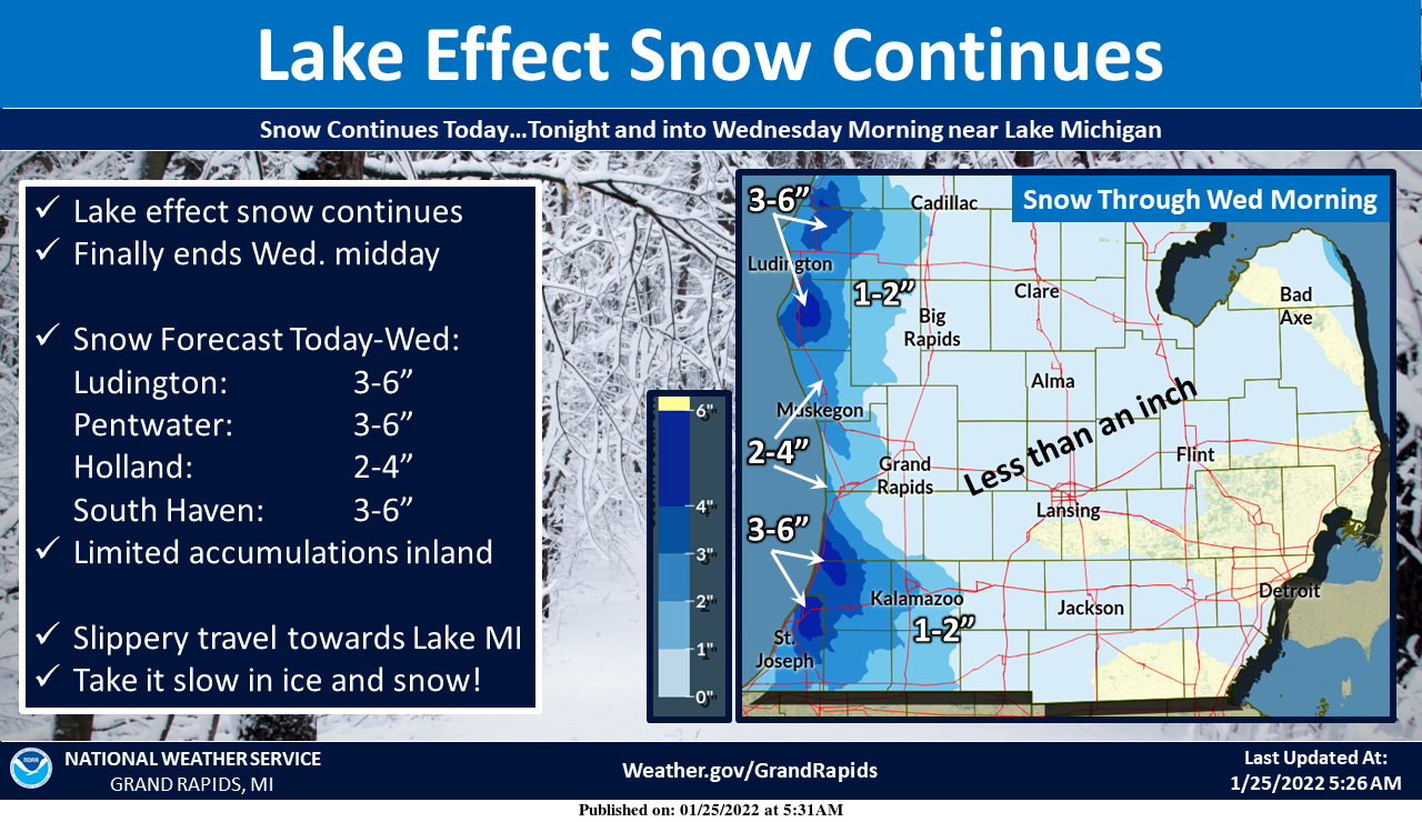
Lake effect snow will continue across the lakeshore counties from today through tonight and into Wednesday morning. 2 to 6 inches of new snow can be expected by midday Wednesday where the lake effect persists. Inland… snow accumulations will generally be less than an inch. It will remain cold today with highs in the teens which are 10-15 degrees below normal. Wind chill values today will dip to around zero F. If traveling towards the lakeshore be prepared to encounter snow-covered and slippery roads.
Forecast Discussion
-Lake effect snow until Wednesday

North west flow across the lake will continue today and tonight
potentially continuing till Wednesday morning with additional
accumulations in the 2 to 4 range in some locations. The best
fetch tonight is in the NW corner counties, and in the SW corner
counties. Latest NAM12 is showing 60 J/kg of CAPE just offshore,
that coupled with the fetch across the lake, is enough instability
for snow showers. The Bufkit soundings show a saturated DGZ with
strong NW flow and Omega maxes which is a recipe for significant
lake effect snow. MKG this morning has that as well, though there
is weaker omega values. The winds will shift to a more westerly
direction this afternoon, in the 15Z to 18Z range, cutting off the
deeper fetch. This will lessen the strength of the snowfall and
its extent it will reach inland. However, that lull will only be
for 6 hours and by 03Z winds the shift to NW and the lake effect
machine will kick start again, bringing more snowfall tonight into
tomorrow morning. Current advisory is till 7 pm and anticipating
potentially extending that until 7 am Wednesday. However, will
wait to see how the trough looks as it is advecting very cold and
slightly drier air. The air will be in the -20C range at 850mb
and at that temperature its hard to pile up snow and will be a
limiting factor for accumulations.


-Cold wind chills Wednesday with another clipper Thursday.

  As alluded to above, bitterly cold air will advect into the
region tonight into Wednesday morning. 850mb temperatures look to
register in the -22C range. The winds will be out of the
northwest and while they will not be to strong, it doesn`t need to
be to drop wind chills to near advisory criteria. Given the col
air mass that moves over the region with light winds, the wind
chills Wednesday morning could be in the -5 to -15 range,
especially along the US 10 corridor and along US 127. That
bitterly cold air will be thankfully short lived as warmer air
will advect into the area from the south. Warm air is a relative
term as at 850mb it is still -5 to -10 C. That slightly warmer air
will be a precursor to another clipper that will move into the
region Thursday bringing the next chance for widespread snowfall
across lower Michigan.
Only 17″ degrees outside so forgot what 40’s feel like lol….. No Heat in sight for the umpteenth day in a row and more snow on the way
INCREDIBLE …inDYY
Interesting study released from NOAA, stating the average coldest day of winter east of the rockies has shifted, with many areas 6+ days later than the old 1981-2010 average. I definitely agree with this. December seems to be getting warmer, Jan/Feb have not changed much.
Here’s the link. Thought I posted it: https://weather.com/science/weather-explainers/news/2022-01-21-coldest-day-of-the-year-us-changing
Cool! I think it’s the summer and fall time warmth that is pushing real winter cold back to January/early February. With so many short winters in a row now, we have certainly seen this play out on a large scale in Michigan.
Nice find! Certainly lines up with our very mild December’s we’ve been having.
Here is where Grand Rapids is at so far this January and winter season. For January as of yesterday AM January total snow fall 23.8″. Average for January 1 to the 24th is 17.6″ that is +6.2″ for this time in January. For meteorological winter the total snow fall as of yesterday AM is 38.4″ that is a departure of -4.5″ and for the season so far Grand Rapids has recorded 43.6″ that is a departure of -2.2″. There has been at least 1″ of snow on the ground now for 29 days (today will be 30) and at this… Read more »
Thanks for the stats Slim! It has been a rather uneventful season so far except for a few days a couple weeks ago that gave us close to 50% of our snowfall so far. We’ve been getting an inch or 2 here and there or a couple tenths once in a while, but no big dumps or storms, other than the aforementioned event a few weeks back. And boy, who would believe we are actually below average in snowfall. From some of the posts on here one would think we were on pace for a record total.
FACT – no warm up in sight! And when a small warm up finally hits in February it will only get temps to near normal = tons of SNOW!!! Who wouldn’t snow in MI this time of year? Keep it rocking! I love it!
What a winter, what a cold spell and we are still well above average for January snowfall! Also all signs point towards a snowy February! In fact I expect February to be our biggest month for snowfall! Wouldn’t that be awesome!
We are still below average snow on the season. Looks pretty quiet. And I see a warm up coming!
Lol….InDY
Delusional!
Well from a snowy November to a snowy end of December all the way through January and now just with about 30 days of snow on the ground and very cold temperatures one has to admit this is a dandy of a Winter we are having in west Michigan…. 😀….InDY
Incredible!
There was 2.2″ of new snow fall yesterday. Overnight just a trace of new snow fell. There is now 6.2″ of snow on the ground here. The overnight low and current temperature is 15. That looks to be the official overnight low at GRR as well. Back in both 1967 and again in 1978 late tonight (January 25) was the start of the two biggest Blizzards in my lifetime. Not only were the dates the same but both years the day of the week was the same (Wednesday)
Slim