We received about .3 inches of snow overnight – the current temperature at 6 am is 16°. Yesterday’s high was 28°, it was almost pleasant working outside in the snow. Today will be cooler with the passage of a cold front with highs struggling to reach 20°. Berrian County is under a winter storm warning with the lake effect bands setting up on a northerly wind.
Forecast
Weather History
1907: Southerly winds bring moist and mild weather with highs in the 50s followed by heavy rains as a cold front moves through. Grand Rapids sets a record high for the date of 56 degrees along with a record rainfall total of 1.84 inches.
1979: A homeowner was killed when his garage roof collapsed due to the weight of the snow on it. Several other homeowners suffered injuries as roofs collapsed throughout southwest Michigan. There were more than 50 reported roof collapses by the end of February, with most of the collapses occurring in the second half of January. At one point the snowpack was measured as weighing more than 25 pounds per square foot.
1994: Temperatures remain below zero all day long. Extreme cold prevails from the 14th to the 21st but this is the coldest day. Grand Rapids ties the all-time record low for the month of January with 22 below zero, followed by a high of only 2 below zero. An unofficial low of 53 below zero is recorded in the Upper Peninsula at Amasa, Michigan. Water and sewer pipes freeze, causing 50 million dollars in damage across Michigan.
On January 19, 2019, a long-duration snowfall was ongoing across Southeast Michigan with a few bands of heavy snow forming over Metro Detroit and locations to the south. These areas saw the highest totals from this 18-hour snowfall, coming in around 5 to 8 inches.
On January 19, 1994, the daytime temperature rose to only -4 degrees in Detroit. This is the coldest maximum temperature ever recorded in the city of Detroit!
U.S.A and Global Events for January 19th:
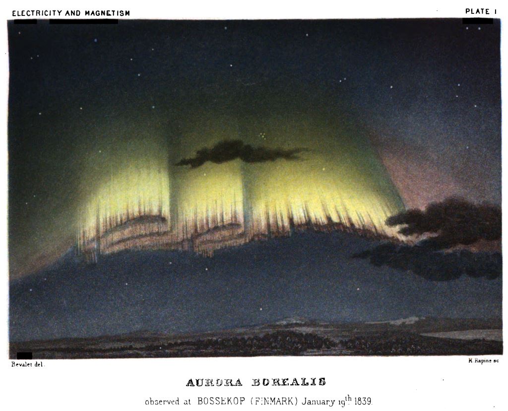
1839: An Aurora Borealis observed at Bossekop, Norway, on January 19th, 1839. Illustration from ‘Electricity and Magnetism’ by Amedee Guillemin (1826-1893), published in London in 1891.
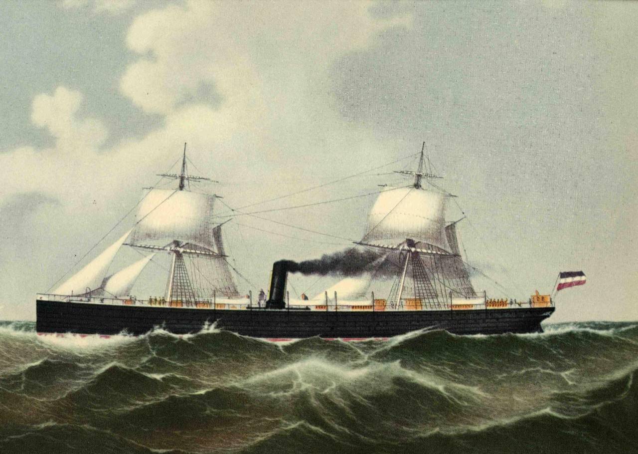
1883: The steamers of Cimbria and Sultan collided in the North Sea due to dense fog. This collision resulted in the death of over 350 people.
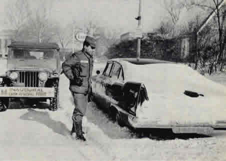
1961: Eight inches of snow fell and caused crippling traffic jams around the Washington D.C. area on the eve of John Kennedy’s inauguration. The president-elect had to cancel dinner plans and, in a struggle to keep other commitments, reportedly had only 4 hours of sleep. Former President Herbert Hoover was unable to fly into Washington National Airport due to the weather, and he had to miss the swearing-in ceremony.
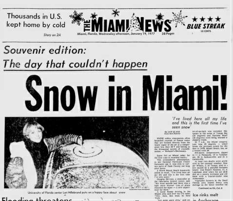
1977: Snow fell in South Florida for the first time in recorded history. Click HERE for more information from the NWS Office in Miami, Florida.
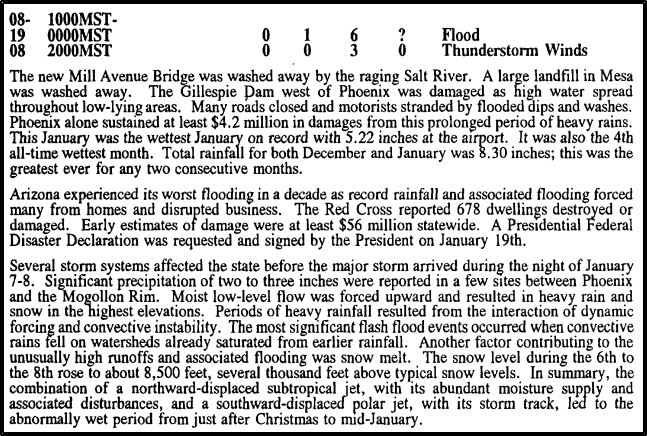
1993: An unusual series of Pacific storm systems tracked across Arizona from January 6th through the 19th, producing heavy and prolonged precipitation across the state. These heavy rains caused the most widespread and severe flooding in Arizona since the turn of the century. The protracted rainfall over the 2 weeks caused multiple flood peaks on most streams and rivers. A large garbage landfill and portions of the new Mill Avenue Bridge under construction were washed away by the raging Salt River. The Gillespie Dam west of Phoenix was damaged as high water spread throughout low-lying areas. One man drowned while trying to cross the Agua Fria River. The image below is from Storm Data.
1996: January 1996 is known as one of the worst snowmelt floods on record for the Mid-Atlantic. The region saw blizzard conditions on January 6 and 7th, which produced 15 to 24 inches east of I-95, and 2 to 3 feet of snow west of I-95. With a tremendous amount of snow on the ground, on January 19, temperatures soared into the 50s and 60s ahead of an approaching cold front. At 7 am in Washington, D.C., was reporting a temperature of 60 degrees with a dewpoint of 60 degrees, both unusually high for a January morning. The warm temperatures combined with rain to melt much of the snowpack, released into the waterways. Click HERE for an excellent webpage from the NWS office in Baltimore/Washington about this event.
Forecast Discussion
- System Snow Winds Down This Morning

A fast moving upper wave is bringing light snow to the area this
morning. We have a Winter Weather Advisory out along I-94.
Visibilities have not been significantly reduced this morning
with most sites reporting 2-4 miles in snow. AZO is down to 1
mile as of 302 AM. The back edge of the snow is already working
across Northern Illinois. We do not expect significant changes
in snow intensity this morning and travel speeds are not overly
impacted at this time. All of that said, we will let the
current headline play out given ongoing snow. Bottom line, most
snow totals over the southern half of the forecast will likely
end up in the 1-3 inch range from this event. Travel impacts
during the morning commute will be the biggest hazard.

- Accumulating Lake Effect Snow Tonight into Saturday

The most significant weather of the 7 day forecast will come
tonight into Saturday as lake effect snow impacts the lakeshore.
We have decided to hold off on any headlines for Tonight-
Saturday given a Winter Weather Advisory already being out and
the transient nature of the snow bands. Moisture is fairly deep
at times tonight with moisture extending to near 700mb or 10,000
feet roughly. A dominant band will be in place initially tonight
off shore (in NNW flow). The band is expected to be pushed
inland tonight and become more wind parallel bands on Saturday
as the flow backs to the NW. Dominant band snow can put down
several inches of snow quickly. Courser resolution models are
hinting at 2-4 inch type amounts over 24 hours. We think higher
amounts are possible with high resolution models suggesting 4-8
inches during the Tonight through Saturday time frame. Most
favored areas for heavier snow will be the northwest corner of
the CWA up towards Ludington where a Lake Superior connection is
expected. A longer fetch into areas south of Holland is the
other favored area. Some of the heaviest snow will be late
tonight into Saturday morning. Confidence is not high at this
point in terms of amounts. We coordinated with APX and the
decision was to hold off on headlines at this time.

We will see wind chill values flirt with advisory numbers
tonight inland, but at this time feel a headline is not needed.

- Warmer With Rain Next Week

The cold air that has been in place for about a week now will
quickly be shunted north early next week. As the warmer air
moves in we will see the chance of a wintry mix from Monday into
Tuesday. By mid week however we are seeing all rain as a
precipitation type given 850mb temperatures that are trending
into the +2 to +4 C range. Quite the chance from the -18 C air
at 850mb that is expected the next 24 hours. The ECWMF snow
depth change prog is showing an erosion to the snow pack across
the southern CWA but much of it hanging on across Central Lower
Michigan. Highs around 40 are expected from mid to late next
week.
Snowless winter = January is over 100% above the normal monthly snowfall! I call that a great snowy month! Facts people, facts!
Now tell me about November and December
Last checked yesterday Lansing was less than 3” below average for snow. So much for the snowless pattern in this area! Incredible!
And GR is only about 8 inches from normal! You
mean winter is not canceled?
Who knew?
We have about 4” on the ground for the moment.
This is the best stretch of cold, snowy weather that we seen in a while! It is creating Heaven on Earth! I love it! Make sure you get outside a lot this weekend to enjoy the winter wonderland! Fantastic!
Torregrossa is on board with the pattern reverting back to the not-so-cold side as we’ve had this entire winter, outside this past week, of course. My favorite part:
“Right now there are no signs of a plunge back into the Arctic deep-freeze. A cold spell will probably happen again one more time this winter sometime in February. The longer the cold spell waits to happen, the less severe the cold spell.”
https://www.mlive.com/weather/2024/01/now-the-big-warm-up-and-why-it-might-last-a-while.html
Crazy talk! We will clearly see at least 2 or 3 more cold spells! Mark it down and check back with me around late March! It could be wild!
I trust Torregrossa the most Mark! No hype, no wishcasting, just puts out real weather info. This past week wasn’t even a pattern change, it was a blip in a warm snowless winter!
I don’t mind torregrossa, but the statement that the longer the cold spell waits to happen the less severe it is just not exactly an accurate statement in some cases. We have had some brutally cold and snowy marches. I think back to 2014 for reference.
Great news! This will not be a short winter! The warm weather fanatics have making this statement for years and are always wrong! We will see multiple snowstorms in Feb and at least 2 in March! Get ready to keep the rock n roll party cranking till Spring! Incredible!
Beautiful! 8 days in a row with snow and tomorrow will make 9 in a row and a perfect winter weekend for outdoor sports! Wow, wow, WOW!!!!!!!!!!!!!!!!!!!!!!!
Beautiful!
Spectacular!!
Magnificent!!!
BRING ON THE HEAT!!
If Upper 30s low 40s is heat, then what is summer when it’s 80+?
In looking at the long range CPC guess, it looks like this weekend will be the end of this cold spell and next week will be the start of a long mild spell. So as Mookie likes to say this may be a “short” winter.
Slim
Absolutely Slim! Already is a short winter! Didn’t even start til mid January this year!
This is nice story. But it’s also a reminder that the ice is just not safe in most places. The Soo Locks finally closed for the season just two days ago.
https://www.wlns.com/news/michigan/ap-michigan-man-who-fell-into-icy-lake-rescued-after-officer-uses-mans-dog-to-deliver-rescue-equipment/
Getting partial sun here for what seems like the first day in 2 weeks! Wow!
I think storm team 8 had a graphic that showed we have had at least a trace of snow everyday for the past 2 weeks so you probably are correct on that for the Grand Rapids area.
Getting sun again today. I believe this is the third day this week with sun. I’m looking forward to the annual January thaw next week to wash the salt and grime off the roads.
8 straight days with measurable SNOW! The beat goes on and on! The winter conditions are so great I decided to head up to snow country for the weekend! Skiing here I come! Nothing better than winter in MI!
The official H/L yesterday at Grand Rapids was 23/17 there was 1.2” of snowfall there has now been 14 days in a row of some snowfall. In that time there has been 29.8” of snowfall. There is now 13” on the ground at the airport and 16” here in MBY. The sun was out 4% of the possible time yesterday.
Slim
For today the average H/L is 31/18 the record high of 56 was set in 1907 and the record low of -22 was set in 1994. The wettest January 19th was 1.85” (all rain) set in 1907. The most snowfall of 6.4” fell in 2003 and the most on the ground was 21” in 1979. Last year the H/L was 42/34. At the current time it is 15 here in MBY with light snow falling.
Slim