Temperatures in the 20s will seem warm after the frigid single digits and teens we have seen over the past few days. Yesterday a good portion of the day we saw sunny skies in Otsego which was another added bonus. We had a high of 18° and a low of 2° with another inch of snow to add to our total which brings us to 17.5 inches for the month and 27 inches for the season.
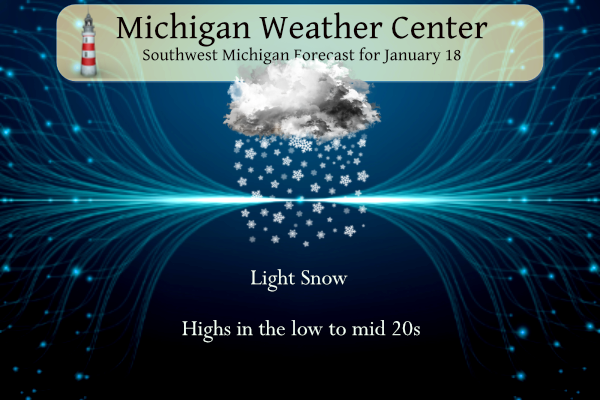
The forecast continues to feature snow and cold. Two particular periods of increased snow intensity and coverage are expected, especially south of a Muskegon to Alma line: this morning and again tonight into Friday morning. A significant warm-up is coming next week with rain by midweek.
Forecast
Weather History
1857: Extreme cold weather prevails across the eastern United States. In Lower Michigan, a temperature of 28 degrees below zero was reported in Grand Rapids.
1976: Arctic air and deep snow result in record cold across interior Lower Michigan. The temperature plunges to 25 below zero at Lansing and 20 below at Jackson. Along Lake Michigan, clouds and an onshore flow keep lows from falling below zero. The low of 10 above at Muskegon is 35 degrees warmer than the low at Lansing.
1996: A blizzard moving through the Dakotas pulls warm air up over Michigan. Record highs in the upper 50s and lower 60s are followed by a line of heavy rain and severe thunderstorms. At least one weak tornado is spawned by the squall line, which is quickly followed by a blast of arctic air and rain changing to snow. Rapids snowmelt and heavy rains, followed by a quick freeze, led to many areas of ice jam flooding.
On January 18, 2020, heavy wet snow occurred during the morning hours with rates exceeding 1 inch per hour at times. This left a wide swath of 5 to 7-inch snow accumulations focused from Flint south to the Ohio border.
On January 18, 1976, the overnight temperature dropped to a freezing -25 degrees in Flint. This is the record low for the city of Flint, as well as the coldest temperature recorded in either Flint, Saginaw, or Detroit!
U.S.A and Global Events for January 18th:
1943: Idaho’s coldest night on record occurred as the low temperature dropped to 60 degrees below zero at Island Park Dam.

1950: Oregon continued in the grips of one of its worst winter months ever. A significant winter storm brought a thick glaze of ice to Columbia River Gorge, stopping automobile traffic in its tracks. Hundreds of motorists were stranded and had to be rescued by train. Even that wasn’t easy with the coating of ice. The storm caused widespread power outages.

1971: A warm Santa Ana condition brought a 95-degree reading to Los Angeles, the highest January temperature on record. It was 95 degrees in Palm Springs, the highest temperature on record for January as well.

The image above is from the January 1971 Climatological Data for California.
1973: The first tornado death of the year has been registered north of Corey, Louisiana, during the afternoon hours. Although a girl was killed when a tenant farm was destroyed, a baby received only minor injuries when it was carried 300 to 400 yards by the tornado. Click HERE for more information from TornadoTalk.com

The image above is from Storm Data.
1978: In Connecticut, the Hartford Arena collapsed after experiencing the largest snowstorm of its 5-year life. Multiple issues caused the collapse. Click HERE for more information from ConnecticutHistory.org

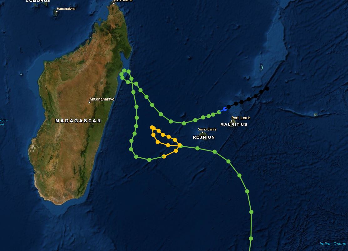
1980: A tropical depression that developed on January 15th became Tropical Storm Hyacinthe on the 18th. From the 18th through the 27th, this storm produced a world-record rainfall amount of 223.5 inches at Cratère Commerson on La Réunion. Click HERE for more information from the Hurricane Research Division.

The hurricane track below is from NOAA.
Forecast Discussion
- Light snow through the first half of Thursday

 Westerly flow will keep lake enhanced snowfall across areas I-96
northward. Any snow from these bands will be fairly light
however it will be enough to reduce visibilities and slow down
the morning commutes. Expect for these snow showers to fade this
afternoon into early evening. Along the I 94 corridor warm air
aloft from a passing synoptic system will allow for more
snowfall. This is in conjunction from from an upper level wave
moving through. Best area of snow continues to be where this
wave is lake enhanced, in Van Buren and Allegan counties.
Overall around an inch or less is expected with slightly higher
amounts along the southern lakeshore.

- Travel Impacts possible from potential snow tonight into Friday

A more potent upper level wave will propagate through region
tonight into tomorrow. An upper level trough will set up over
Lake Michigan with a mid level closed low moving through the
Ohio Valley into Friday. Best area for moisture will be along
the I 94 corridor and along and east of US 127. As the before
mentioned low moves through Central Ohio it will bring easterly
flow coupled with cold air aloft and upwards of a quarter inch
of QPF. The easterly flow off of Saginaw Bay could play a role
in increased snowfall into the US 127 corridor. Currently 2 to 5
inches is possible with the heaviest falling late tonight early
Friday morning. A strong band could set up along the I 94
corridor which could cause issues with the Friday morning
commute.

- Bitterly cold temperatures this weekend

 Models are in good consensus for the region to have cold dry
air move over the region in the wake of this exiting low
Saturday morning. With the dry air and cold polar air moving
over top Michigan temperatures should tank. Air at 850 mb looks
to be around -18C which should SFC temperatures in the 0 to -10F
range. While Sunday will be slightly warmer, high pressure
building over the Great lakes region should stifle cloud
development and allow for radiational cooling. So lows in the
single digits are possible Sunday. Wind chills on Saturday
morning will be a concern, though it is the weekend readings of
-10 to 15 are possible, especially in south central Michigan.

- Warm up next week

 As previously stated a series of systems will bring warmer air
into the region beginning early next week. Temperatures will
gradually increase through the week and are expected to be
above normal through the latter half of the week. 850mb
temperatures of 5 to 10 C are possible late next week. Rain is
possible late next week though any specifics are varied at best.
I am not sure how it could be better! 7 days in a row with snow and temps well below freezing and a great weekend for winter sports coming up! Get outside and enjoy the best season in MI! Incredible!
Well this is a sign of how this winter has gone so far, we are heading toward the end of January and cannonsburg is just opening this weekend!
And the Soo Locks finally closed for the season yesterday.
That is insanely late!
Got my wife’s car all cleaned off now. And did the part of the driveway were it was parked. The car had 18″ of snow the bottom 2″ or more was that wet snow that fell before the lake effect snow fell. It was a lot of hard work getting it all off the car. But it is all clean now. Also did the driveway where it was parked with the snowblower.
Slim
The updated CPC long range guess continues the mild and dry trend into February.
https://www.cpc.ncep.noaa.gov/products/predictions/long_range/lead14/index.php
Slim
And into the start of spring
https://www.cpc.ncep.noaa.gov/products/predictions/long_range/seasonal.php?lead=1
Slim
So it appears that El Nino has not gone away just yet.
Typical El Niño outlook! I see the Polar vortex making at least one visit in February and at least two major snowstorms! It could be a wild month with about 20 + inches of snow! Bring it!
We could get even more snow than that. Or, we could get very little snow and temps above freezing all month. Keep in mind that average high temp for today is 31 degrees. We’ll just have to wait and see.
False Mark! There is a zero percent chance that in the month of February will have no days with highs below freezing! I will bet you any amount of money and I give you 100 to 1 odds! In fact I will bet anyone willing to put their money where their mouth is on this bet!
You’re willing to bet that not one day in February will have a high <32? I don’t want to take your money. 😂
No you are misunderstanding the bet and your original comment! We will find something better to bet on later!
Nope. What you said is crystal clear. You said it would be impossible that “the month of February will have no days with highs below freezing.” I’m sorry, but the odds are that at least one day in February will have a high temp below 32.
BTW, I don’t bet. I work too hard for my money just to piss it away on a prediction.
Right on Slim, keep putting out those FACTS!!
Boy it is really hard work clearing off 18″ of snow on a car. My wife’s car is parked outside off to the side of the garage. I am now in the process of cleaning off the car. Boy talk about a lot of hard work. I am using the broom for the garage. The top lake effect snow is easy to get off but the old wet snow is not so much. It is up to 23 here in my yard now but but when one is out there for a while it is still cold.
Slim
Parts of GR have picked up about 2 feet of snow in one week! Can you say Wow, just wow, WOW!!!!!!!!
I have 18″ on my snowboard and around 16″ on the ground. My wife’s car had 18″ on its top. A lot of work getting that off.
Slim
The wish caster Matt Kirkwood just said 1-3 inches of snow tonight for GR what wait a minute more snow?? No way !! who know??? INDY
Who would have thought? What a fantastic stretch of winter weather! Rock n Roll will never die!
>>>>>>BREAKING>>>>>Perfect weather for a winter sports weekend! Get outside and enjoy the cold and snow! What a stretch or near perfect winter weather! I absolutely love it!
Tip Up Town organizers are already starting to cancel some events, unfortunately. If anyone is heading up there, check with Lyman’s on the Lake bait shop and/or the Houghton Lake Chamber of Commerce. They will have the latest info.
Our snow wave has been longer then any heatwave we had last Summer did we even have one ?? Lol !! Let it snow let snow let it snow…INDY
Rocklin Indy – you are 100% correct! Keep the facts coming!
Great news…. The so called “pattern change” is short lived and then bam right back to above normal temps and no snow as it has been this winter! I love it!
Yeah, what happened to the big pattern change? More like a quick cool down before resuming the warm temps!
I’m in Jackson and about 2” of fresh snow fell here on the north side with slick roads. It just keeps coming!
The snow just keeps coming even though some are talking about a non existent blow torch. A few above normal days and then bam! Incredible!
Bring on more cold and snow!
Great news…. The so called big warm up will be short lived and then bam right back to cold and snow! I love it!
“From the 18th through the 27th, this storm produced a world-record rainfall amount of 223.5 inches at Cratère Commerson on La Réunion.”
Holy smokes, how is that even possible??? That’s just over one inch of rain per hour for nine consecutive days.
Too bad it wasn’t snow!
Woah the temps keep getting bumped up next week. Rain and low to mid 40’s? Expect lots of flooding and horrible winter activity conditions.
Yeah… Maybe we can pull out the sleds today!!! It has been too cold to be out there for too long. I like to feel my face when I come in. Lol.
Yes, for those without proper arctic gear today will be much nicer, but for me it will too warm to bundle up. Prob just a light coat, gloves and ear muffs! Great stretch of winter weather!!!
Yes, we only have 5 days to enjoy the snow before rain and melting next week.
I know bummer!!
Thinking I may try to roof rake some too
The SNOW just keeps coming and coming! Bring it!
https://www.pivotalweather.com/model.php?p=snku_acc-imp&rh=2024011806&fh=240