Didn’t put up the weather history last week when I was on vacation – I will present this weeks today then proceed with the forecast information.
December 31
1875: The year ends on a remarkably balmy note. At Lansing, the high temperature of 70 degrees is the highest ever recorded in the month of December.
1976: One of the coldest Decembers on record ends with a second consecutive day of record lows across Lower Michigan. The temperature falls to 15 below zero at Muskegon, a record low for the date and for the entire month of December.
January 1
1876: The year begins during a three day spell of record warmth. Lansing hits 65 degrees, after setting a record of 70 degrees the day before.
1964: Arctic air sets record lows across Lower Michigan on this New Years Day. The temperature falls to 15 below zero at Grand Rapids and Muskegon hits 9 below.
1985: A severe ice storm struck southern Lower Michigan as a layer of ice up to one inch thick downed tree limbs and power lines. There were three deaths and eight injuries directly related to the ice storm. Over 430,000 electrical customers were without power, some for as long as 10 days. Total damage was estimated at nearly $50 million.
January 2
1876: Record highs are set for the third day in a row at Lansing and Detroit as the temperature reaches 62 degrees at both locations.
1999: A powerful winter storm gets underway with heavy snow and high winds shutting down travel for the next several days.
January 3
1897: Warm and wet weather prevails as a cold front approaches. High temperatures in the 50s are followed by heavy rain. This is the wettest January day on record at Muskegon, with nearly 5 inches of rain.
1918: The temperature falls to a record low of 16 below zero at Muskegon during one of the coldest months on record in Lower Michigan.
January 4
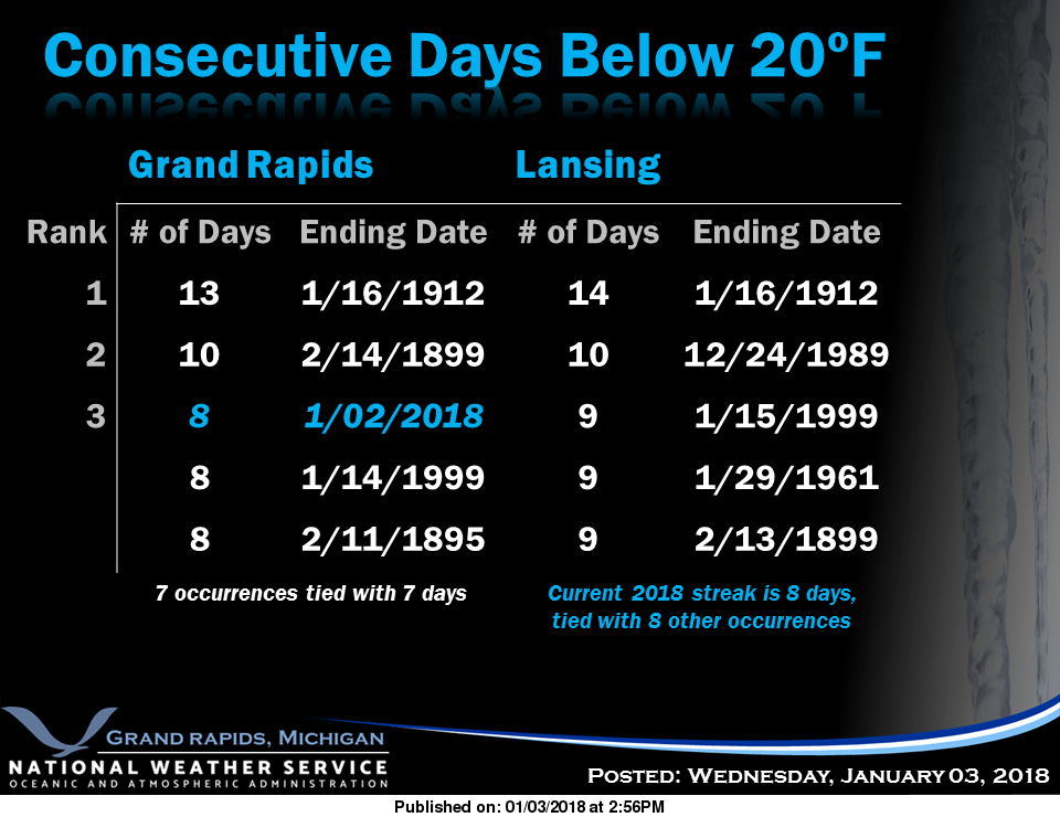
1981: Arctic air is firmly entrenched across Lower Michigan with extremely cold temperatures prevailing for the first half of the month. Eight of the first twelve days of the month fall below zero at Lansing. This is the coldest morning with a low of 29 below zero. This is the all-time low for the month of January at Lansing and the coldest temperature of the 20th century there. The temperature falls to 20 below zero at Grand Rapids and 15 below at Mount Pleasant.
1999: West Michigan is digging out from 1 to 2 feet of snow, with drifts of several feet as the Blizzard of 1999 slowly winds down. Lake effect snow will continue the next several days, however.
January 5
1912: Arctic air dominates Lower Michigan during the coldest January on record. Muskegon plunges to 12 below zero for a record low for the date.
1998: Moist southerly flow brings warm and wet weather to Lower Michigan. Highs in the 50s follow morning lows in the 40s as several days of thawing weather are observed during the first week of January.
1946: Record highs are set for a second day in a row across Lower Michigan as temperatures reach the mid and upper 50s.
January 6
1999: Heavy snow piles up on top of the snow dropped during the blizzard a few days earlier. Another 9 inches of snow at Muskegon brings the snow total on the ground to 30 inches, with snow drifts several feet high. This will be the snowiest January on record at Grand Rapids with 46.8 inches of snow and Lansing with 34.6 inches.
2014: A three day seige of heavy snow and extreme cold begins. Frequent white out conditions and temperatures hovering near zero make travel hazardous and at times almost impossible. The phrase ‘polar vortex’ enters the weather lexicon during this time.
 Blizzard warnings are up for a good chunk of Maine for heavy snow and winds 45 to 55 mph sustained and over a foot of snow, higher amounts in the upper highlands where I used to live. This is from the nor’easter going up the coast. Travel will be impossible as all the roads drift shut with drifts several feet deep. I have experienced these – its amazing the amounts of snow we used to get in the mountains from these nor’easters.
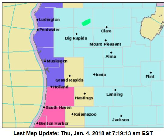
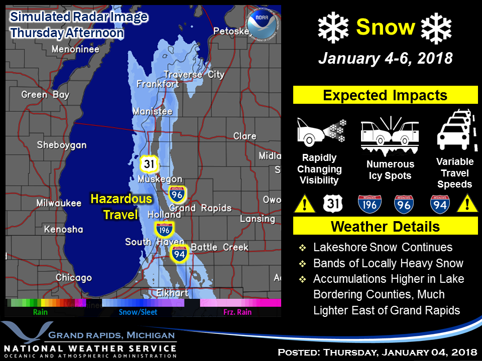
Not that exciting here as the snow will be confined to western Allegan and Van Buren counties with snow
accumulations of 6 to 10 inches, with localized amounts up to 21 inches, are expected.
Snow showers will continue into Saturday morning near the Lake Michigan shore, with areas of extreme western Allegan and Van Buren Counties seeing the heaviest snowfall amounts. The snow bands will more around some so it will not be snowing at any one place all the time.
By mid morning Saturday local snowfall amounts should be well over a foot from this event. Travel down I-196 south of Holland and also on US-31 along its entire length will be challenging at best the next few days.
Meanwhile areas near and east of US-131 will see just cold temperatures with wind chill values near -15 degrees this morning and closer to -20 degrees tomorrow morning. Little of any snow is expected east of US-131 into Saturday. It also seems we will see some snow Sunday and a significant warm up Sunday into Monday before another arctic cold front brings more cold air back to the area.
[columns] [span6]
[/span6][span6]
[/span6][/columns]
Today: A 40 percent chance of snow showers after 1pm. Mostly sunny, with a high near 15. Wind chill values as low as -1. North wind 6 to 11 mph, with gusts as high as 21 mph.
Tonight: A 40 percent chance of snow showers. Mostly cloudy, with a low around -2. Wind chill values as low as -10. North northwest wind around 5 mph.
Friday: A 50 percent chance of snow showers. Increasing clouds, with a high near 11. Wind chill values as low as -10. Calm wind becoming north northeast 5 to 7 mph in the morning.
Friday Night: A 30 percent chance of snow showers. Mostly cloudy, with a low around 1. Wind chill values as low as -6. North northwest wind 5 to 7 mph becoming calm after midnight.
Saturday: Mostly cloudy, with a high near 13. Calm wind becoming south southwest around 6 mph in the afternoon.
Saturday Night: A 20 percent chance of snow after 1am. Mostly cloudy, with a low around 5.
Sunday: Snow likely, mainly after 1pm. Cloudy, with a high near 29. Chance of precipitation is 60%.
Sunday Night: Snow likely. Cloudy, with a low around 25.
Monday: A chance of snow before 1pm, then a slight chance of snow showers after 1pm. Mostly cloudy, with a high near 34.
Monday Night: A slight chance of snow showers before 1am. Mostly cloudy, with a low around 21.
Tuesday: A slight chance of snow showers. Partly sunny, with a high near 28.
Tuesday Night: A slight chance of snow showers. Mostly cloudy, with a low around 14.
Wednesday: A chance of snow showers. Mostly cloudy, with a high near 26.
Hello lake shore! SNOW, SNOW and more SNOW!!!!
http://www.weather.gov/images/erh/gis/LP_state_Snow.png
Give me teens all winter long = no SNOW melt and great winter sports conditions! Skiing and snowmobiling have been absolutely INCREDIBLE!
-1 now out at the YARDofBRICKS -teens tonight wow stay tuned INDYDOG!!
Thank God this high in the teens BS is gonna be over after Saturday!! Looking forward to the long overdue WARM UP!!
https://weather.com/weather/tenday/l/USMI0344:1:US
So much for the so called “big warm up”! It may up to about normal with plenty of SNOW! If that is the big warm up, keep it coming baby!
http://www.cpc.ncep.noaa.gov/products/predictions/long_range/lead01/off01_prcp.gif
http://www.cpc.ncep.noaa.gov/products/predictions/814day/814temp.new.gif
http://www.cpc.ncep.noaa.gov/products/predictions/814day/814temp.new.gif
Matt must be in heaven. A graphic on Bill’s Blog shows seasonal snowfall. 18″ for Lansing (but no more than 7″ in depth). But Muskegon has had 60″. That figure imprrssed me.
+100 Million! I heading over there on Saturday to check it out!
We just got back from running a couple of errands. The roads are in great shape. I don’t know about the dirt roads we avoided them. I think alot of people had the same idea today. Bundle up- it is cold outside!! LOL!! 🙂
15* with about 17 inches of snow on the ground out at thee YARDofBRICKS. Incredible INDYDOG!!
This is more like it!
We begin the temperature rebound on Sunday with southerly winds on
the back side of a departing sfc high, with high temperatures
reaching 25 to 30 degrees. On Monday it looks like most of the area
will reach or exceed freezing, then only a minor cool down occurs on
Tuesday before another warm up ensues for Wednesday into Thursday
when highs near 40 are not even out of the question. The polar jet
retreats during this time and a srn stream trough over the central
plains helps develop a downstream ridge over the Great Lakes Rgn.
While it may not be as warm as last winter there are more and more indications that starting mid January we will turn and it will become warmer and there is a chance that this winter could play out similar to last winter. The other side of the lake has very little snow cover.
Slim
That would be fine with me! Two weeks of frigidness for the Holidays then bring on the WARMER temps!!
56 days until the first day of spring. Just sayin…
And the welcome winds of change are coming!
http://www.cpc.ncep.noaa.gov/products/predictions/814day/814temp.new.gif
The sun is shining here & is really bright on the snow. It is still very cold outside. The sunshine thru a window feels really good.
Yes the sun sure makes it look warm, however the reality = cold!
All the thaw talks keep getting pushed back love keep winter rolling some places along the lk shore have over 40 inches of snow on the ground crazzy! INDYDOG!!
Hey Slim, could you do a side by side stats list of December 2016 and December 2017? I mean like total months snowfall, temperature averages, etc. I’m just curious to see how close together they really were. Thanks!
2016 to 2017 comparison Here is a December to December comparison on snow fall temperatures at Grand Rapids, MI Snow fall December 2016 37.0” December snow fall 2017 32.9” Temperatures December 2016 mean was 27.5° or -1.7° December 2017 mean was 24.9° or -4.8° The warmest temperature 2016 53° warmest 2017 61° Coldest 2016 +4° coldest 2017 -12° Total seasonal snow fall as of January 4th 2017 38.3” 2018 36.7” The case still can be made that this winter could be like last winter a front loaded winter. As for total snow for this this winter season it still could… Read more »
Thanks Slim! Stats wise both December’s are really quite similar. Less snow, a little colder, but very close!
Bring on the warm up – high temps in the low 30’s and some monster snow storms!
Let me remind everyone that we are entrenched in a cold and snowy pattern and the CPC’s winter outlook is for colder than normal temps with plenty of SNOW!!!!!!! For those of you wishing and hoping and predicting a sudden change to above normal temps and below normal snowfall, good luck with that!
http://www.cpc.ncep.noaa.gov/products/predictions/long_range/lead01/off01_temp.gif
http://www.cpc.ncep.noaa.gov/products/predictions/long_range/lead01/off01_prcp.gif
What a winter! Above normal snowfall and below normal temps! How could it be any better than that?
Much has been said that this winter will not be at all like last winter BUT could this be a front loaded winter??? There are signs that the pendulum could swing to a warmer 2nd half of winter. At least the last half of January could be warmer
http://www.cpc.ncep.noaa.gov/products/people/mchen/CFSv2FCST/weekly/images/wk3.wk4_latest.NAsfcT.gif
Slim
As we know anything is possible with long range guesses! I predict a record breaking winter for snowfall in the GR area. Probably a top 3 or 4 winter of all time! Bring it on!
I am seeing a warm up (January Thaw) around the 17th
Climatology for today January 4th At Grand Rapids, MI
The average H/L for Grand Rapids for today is 31/19
The record high is 60° in 1997 the coldest maximum is 10 set in 1981
The record low is -20° set in 1981 the warmest minimum is 39 set in 1909
The largest snow fall is 6.3” in 1941
The most on the ground is 17” in 1999
Last year the H/L was 33/15 and 1.1” of snow fell there was only a trace on the ground at 7AM
Slim
Today will make the 16th day in a row of snow fall here in Grand Rapids. While here at my house I had just over 5” of new snow at GRR they only reported 2.5” The airport reports 8” on the ground and my total this morning is 12.5” for the month of January Grand Rapids is now at 3.2” and for the season the total at GRR is now 36.7” With the cold and sow we have had One has to wonder if the pendulum will now swing back to warmer and less snow in the weeks ahead?
Slim
A heads up Micheal. I will be leaving on vacation on the 16th I should have a internet connection until the 20th but I will not have a connection from the afternoon of the 20th to the 28th
Slim