 Bill Steffen mentioned in his blog yesterday about a quote from Dr. Judah Cohen in regards to the cold air remaining in the long term. At this time there is nothing upstream in the near term to disrupt the current pattern we are in.
“Latest CFS runs predict three straight months of ridging near Alaska and troughing in eastern North America, which would result of three more months of the same – warm in the West and cold in the East.”
Dr. Cohen joined Atmospheric and Environmental Research in 1998. Prior to AER, he spent two years as a National Research Council Fellow at the NASA Goddard Institute for Space Studies after two years as a research scientist at MIT’s Parsons Laboratory. Cohen received his Ph.D. in Atmospheric Sciences from Columbia University in 1994 and has since focused on conducting numerical experiments with global climate models and advanced statistical techniques to better understand climate variability and to improve climate prediction. Cohen develops AER’s long range forecast products for commercial clients who include some of the largest investment firms in the US.
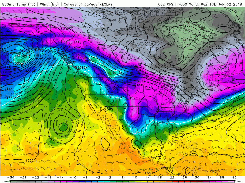
Looking at the CFS model (to the left) I wonder if we will see many days above freezing. The graphic runs up through February 4th. This shows the air temperature at 5000 feet with the light blues to darker greys being below freezing to negative 22 (below 0). It might be a good time to import some polar bears and seals, they may help with the Asian carp problem.
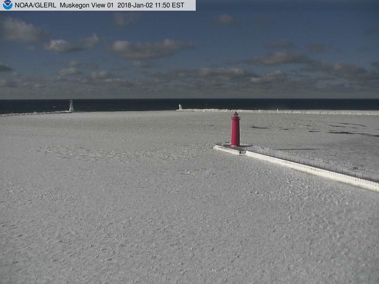
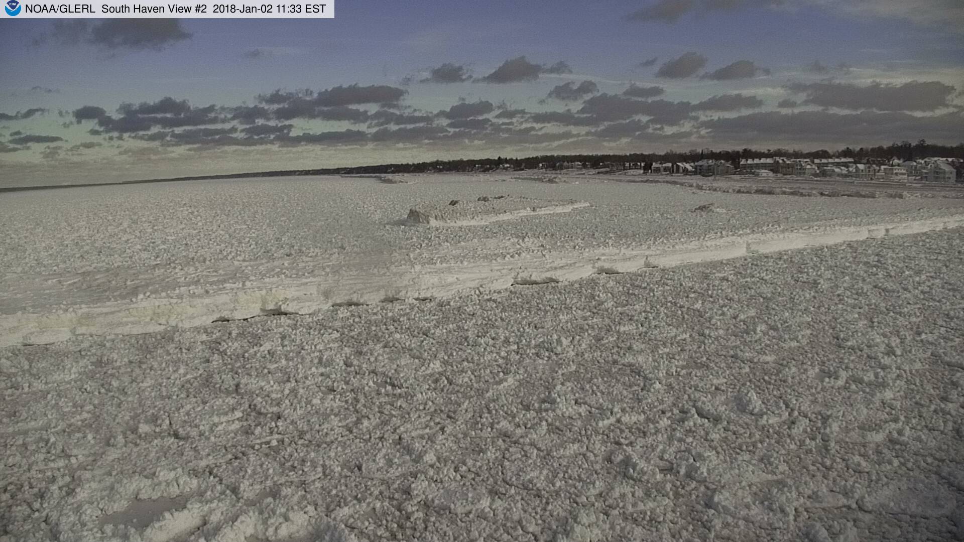
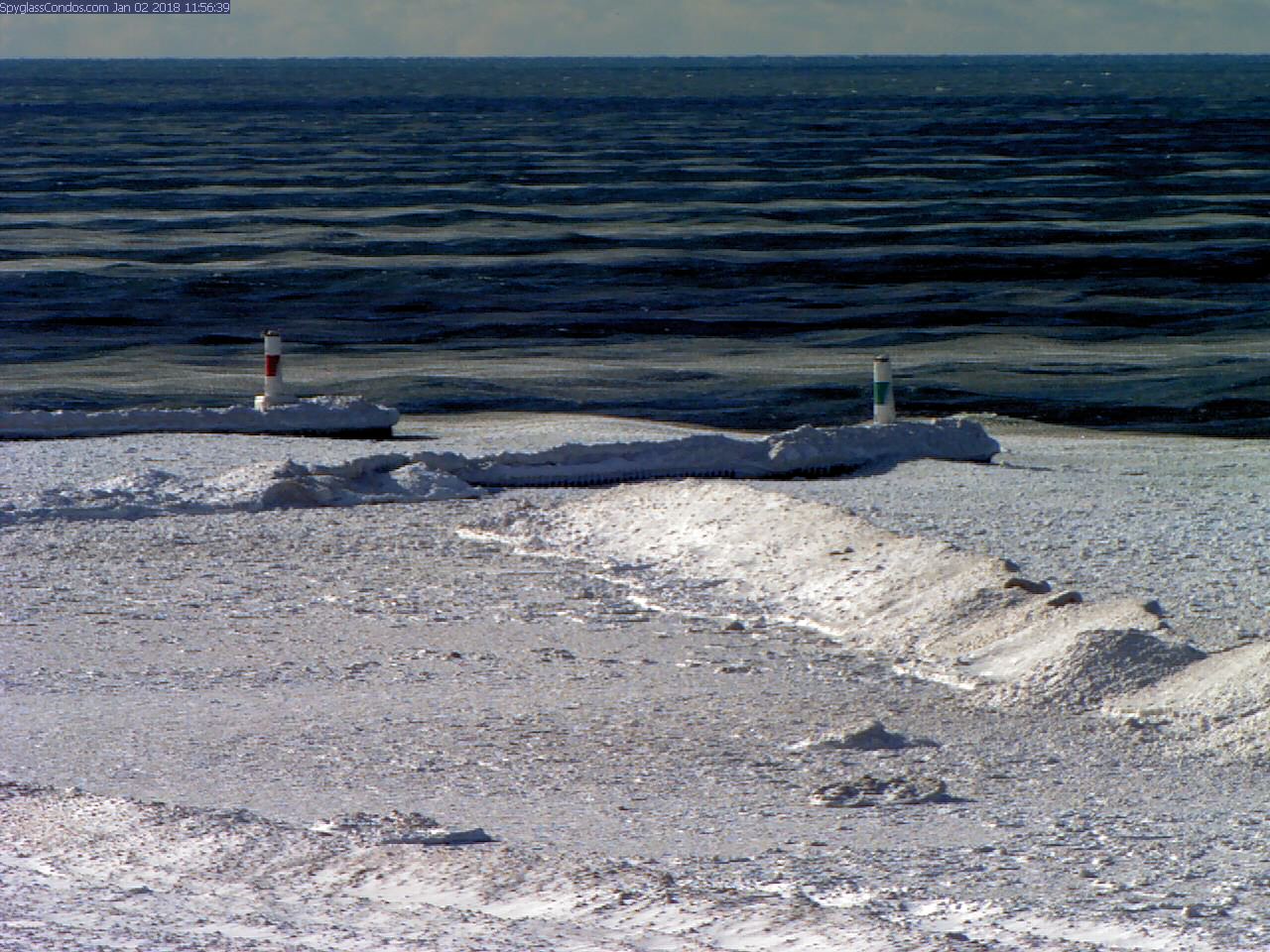
We have been lucky we haven’t had major synoptic events try to push into this cold drier air (this may change as temperatures warm next week). Mainly the western lakeshore counties have been taking the brunt with whatever little moisture can be brought in and lifted inland. I believe this could still go either way with a brief warm up next week but I see no January thaw in the long or short term. As you can see in the webcam photos below (from yesterday) the lake is trying to freeze and the wind will be blowing the ice into the lakeshore.
[columns] [span4]
[/span4][span4]
[/span4][span4]
[/span4][/columns]
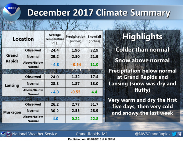
Here is the December Climate summary
A balmy 9° here in Otsego at 7am. We have the Winter Weather Advisory for the Lakeshore counties – Mason, Oceana, Muskegon, Ottawa, Allegan and Van Buren. Snow is currently widespread over the area. The snowfall
rates will be heaviest from mid morning into early afternoon. Later this afternoon as the system snow ends lake snow bands will set up west of US-131 and continue through Friday morning.
Snowfall rates of 1 to 2 inches an hour should be expected in the heavier snow bands tonight through Friday morning. Locations like Big and Little Sable Point and extreme western Allegan and Van Buren Counties are expected to have the greatest snowfall amounts from this event.
There will be some blowing and drifting snow from time to time too. Plan on difficult travel conditions, including during the morning and afternoon commutes into Friday. Additional snow accumulations of 6 to 10 inches, with localized amounts up to 24 inches, are expected.
Expect snow today as cold front trailing a surface low currently over eastern Lake Superior comes through the area this morning. The snow assoicated with this system will come to an end over all but areas near the Lake Michigan shore by this evening. Expect an inch or two near and east of US-131 today with 2 to 4 inches from US-131 to the lake shore.
Tonight our clipper low merges with a very powerful Nor-Easter and that will result in two days of north winds and arctic air. This will mean persistent lake effect snow bands near US-31 with the Big and Little Sable points and extreme western Van Buren and Allegan Counties getting the heaviest snowfall. Those areas could see 2 feet of snow by Friday. Beyond that a southern stream system tries to move into the area late in the weekend or by early next week. That will bring an end to this unusually cold weather but may mean a snow storm. That will have to be watched.
Today: Snow showers. High near 21. Wind chill values as low as -7. South southwest wind 8 to 14 mph becoming west northwest in the afternoon. Chance of precipitation is 100%. Total daytime snow accumulation of around 2 inches.
Tonight: A 40 percent chance of snow showers. Cloudy, then gradually becoming partly cloudy, with a low around 2. Wind chill values as low as -9. North northwest wind 6 to 9 mph.
Thursday: A 40 percent chance of snow showers, mainly after 1pm. Mostly sunny, with a high near 12. Wind chill values as low as -9. North wind 5 to 14 mph.
Thursday Night: A 50 percent chance of snow showers. Mostly cloudy, with a low around 1. Wind chill values as low as -6. North wind around 5 mph becoming calm in the evening.
Friday: Snow showers likely, mainly after 1pm. Mostly cloudy, with a high near 11. Northwest wind 5 to 10 mph. Chance of precipitation is 70%. New snow accumulation of less than a half inch possible.
Friday Night: A 20 percent chance of snow showers. Mostly cloudy, with a low around -1.
Saturday: A 20 percent chance of snow showers before 1pm. Partly sunny, with a high near 14.
Saturday Night: A chance of snow after 1am. Mostly cloudy, with a low around 9.
Sunday: Snow likely, mainly after 1pm. Cloudy, with a high near 32.
Sunday Night: Snow likely. Cloudy, with a low around 26.
Monday: A chance of snow. Cloudy, with a high near 33.
Monday Night: A chance of snow showers. Mostly cloudy, with a low around 18.
Tuesday: A chance of snow showers. Mostly cloudy, with a high near 25.
Late Afternoon Update
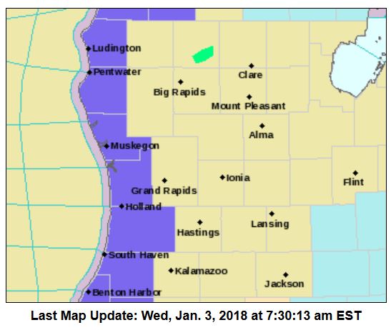
WINTER STORM WARNING IN EFFECT UNTIL 7 AM EST FRIDAY For Allegan and Van Buren Counties
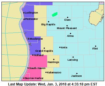
Heavy lake effect snow developing. Plan on difficult travel conditions, including during the commutes from tonight through Friday. Snowfall rates of 1 to 2 inches per hour at times are expected under the heavier bands, with visibilities down to near zero at times. 3 to 6 inches of additional snow is expected tonight with locally heavier amounts likely. Heaviest snow will be toward the coast, with much less inland. Variable conditions are expected.
We’ve had just a few flakes the past few days. Still sitting at 4″ on the ground. Keep it over there. It’s too cold out to deal with it.
A lot of snow here today. It’s not falling at the moment. The roads have been slick all day. It was a good day to stay home here.
Been snowing in Allegan for most of the day – intensity has increased over the past few hours – get to drive to Otsego shortly – yippeee!
Updated the blog to show the warnings for Allegan and Van Buren Counties
A little surprised to see how heavy the snow was coming down for the last hour. Looks lovely but I can live with it retreating to the lake shore for the next couple of days 😉
Snowing very hard again out at thee YARDofBRICKS INDYDOG!!
I love the looks of this and combined with near to below normal temps we may see TONS of SNOW!!
http://www.cpc.ncep.noaa.gov/products/predictions/610day/610prcp.new.gif
The snow has all but stopped here at my house I have 5″ of new snow and now have 14″ on the ground.
Slim
5 inches of new snow this morning/early afternoon and still dumping snow. 1″+ snowfall rates right now.
Keep it rolling on the Lake-shore! INCREDIBLE!
Over 6 inches of new snow on the ground out at thee YARDofBRICKS .. 16 inches now on the ground stay tuned INDYDOG!
10 to 14 days out no sign of a January thaw maybe a few 30’s nothing to warm I’m thinking a few weeks some of the maps showing around the 6th of January being a rainy melt down are a little off!! Can’t trust them long rangers .. INDYDOG!!
Climatology for today January 3rd At Grand Rapids, MI
The average H/L is 31/19°
The record high is 59° set in 204 the coldest maximum is 9° set in 1919
The record low is -9° set in 2014 the warmest minimum is 53° set in 1897
The largest snow fall is 9.1” set in 1999
The most on the ground is 14” in 1979
Last year the H/L was 38/33 and there was no snow on the ground.
Slim
Question for you weather geniuses. How far does the ice need to be from shore for the lake not to produce much in Lake effect snow? Mid Lake? All of the Lake? Was just wondering…
That is a good question. As the water in the lake cools and then forms ice there will be less lake effect snow. With as cold as it has been this year that point is close at hand. As long as there is a lot of wind there will areas of open water but with the lake getting colder in the next two weeks or so the lake effect will become less of a major player that is why we get most of our snow in December and in most years January, By February there is less lake effect snow… Read more »
The lake temp is still in the upper 30’s and long ways off from cutting off lake effect.
The overnight snow fall here at my house is now at 4.2” and I now have a total of 13.5” on the ground here. At this time still getting moderate snow falling. And the temperature here is now 11°
Slim
I told my wife before the season – after three years of pretty much nonexistent winters, we were due for an extended stretch of cold.
Does anyone else think that Kent County should be in the WWA? I have received 3 inches of snow already and it still snowing!
IMO, there seems to be no consistency in the issuance of WWAs. Early in the season, they’re issued when we receive 1 or 2, but later in the season, they’re not issued as often. At least, it seems that way. It’s almost like they’re used just as a heads up for drivers. But by January, most people remember how to drive in adverse conditions.
You make some good points!
I am not sure what the guidelines are for some of the headlines. But yes most of the headlines are for travel. In fact in the old days there used to be a 1. Travelers adversary. 2. Heavy snow watch. 3. Heavy snow warning. There was no winter storm watches nor warnings of course why don’t they issue summer storm warnings???
Slim
The SNOW maps keep getting better and better! Totally different than last year! ROCK n ROLL will never die!
http://wxcaster.com/gis-gfs-snow-overlays2.php?STATIONID=GRRwww.instantweathermaps.com/GFS-php/showmap-conussfc.php?run=2018010306&time=PER&var=ASNOWI&hour=384
What? More cold and snow and it may last for months! Who knew?
What a snowy pattern we are in just picked up over 5 inches of new snow out at thee YARDofBRICKS and still snowing.. now seeing temps getting a little more juicy this week that should me more system snows! Stay snowy INDYDOG!!
Right on!