
 We have an air temperature at -9° and a wind chill of -16° at 7am here in Otsego. There is some hope at the end of the tunnel of warmer temperatures not far away as the bone chilling Arctic airmass retreats back into Canada where it belongs. We may even see some rain late next week and mid month for a January thaw.
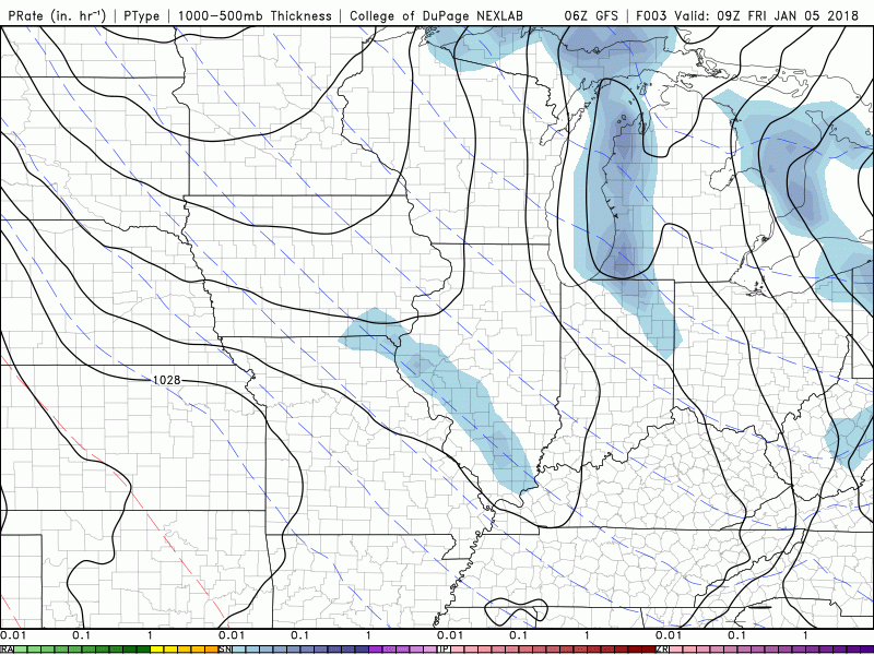
The GFS (to the left) and CFS guesses have been consistent with a warming trend and rain for the past few days.
The big question is if the warming trend will mark the end of winter or will the Arctic air move back in at the end of the month and on into February. Some of the mainstream meteorologists believe the Arctic Oscillation will once again go negative bringing the cold air back into Michigan towards the end of the month. Of course this is dependent on many things happening to the north, the Atlantic and Pacific Oceans. Most thought we would have a back loaded winter this year which of course has started as front loaded. I guess in my mind winter isn’t over yet, we will have a reprieve from the bitter cold air losing our snow pack over the next couple weeks before the cold air returns. My main concern would be having the jet stream closer to the state bringing icing events into the area and of course more synoptic systems moving through which we haven’t had a lot of this month.
 In the short term our concerns are with the cold air and wind chills. Even as I write this the temperature has dropped another degree bringing us to -10°. The snow will remain along the coast with clear skies inland.
We have about 36 more hours of this arctic air we have had over the area since around Christmas. A major change in our weather pattern will begin on Sunday as the polar jet goes north of this area for awhile. This will mean this coming week will be significantly warmer than the past 2 weeks.
Since the arctic air is still over the area today the lake effect snow band will continue to bring locally heavy snow to the lake shore areas. That will come to an end by mid morning Saturday as the lake snow band moves inland and dissipates. Otherwise it will remain cold today into Saturday.
The warmer air comes Sunday. This surge of moisture will bring a period of light snow to the area Sunday into Sunday night. Once in the warmer air we will see highs in the 30s and lows in the 20s most of next week. The next storm will be in the Thursday time frame. This could mean precipitation free weather Monday through Wednesday.
Now a not so brief note on what is changing our weather pattern, making next week much warmer than this current week. As it turns out we have one of those extended East Asian Jet features from central China, across Japan, then across the entire central North Pacific Ocean around 30-35N just east of the Dateline. This will do what it nearly always does, which is break down the western upper level ridge for a week or so. That allows Pacific systems to track due east into the CONUS. Which is what will happen next week. Once the East Asian Jet retreats the western upper ridge will reform and it will get cold here again. What happens after that is still up in the air so to speak.
Today: Snow showers. High near 11. Wind chill values as low as -15. North northeast wind around 6 mph becoming west northwest in the afternoon. Chance of precipitation is 80%. Total daytime snow accumulation of around an inch possible.
Tonight: Snow showers, mainly between 7pm and 10pm. Low around 1. Wind chill values as low as -7. Northwest wind 3 to 6 mph. Chance of precipitation is 80%. New snow accumulation of less than a half inch possible.
Saturday: A 30 percent chance of snow showers, mainly before 1pm. Mostly cloudy, with a high near 14. Wind chill values as low as -7. Calm wind becoming south around 6 mph in the afternoon.
Saturday Night: A 20 percent chance of snow showers after 1am. Mostly cloudy, with a low around 4. Wind chill values as low as -12. South wind 8 to 13 mph.
Sunday: Snow showers. High near 28. South southwest wind 15 to 17 mph. Chance of precipitation is 90%. New snow accumulation of less than one inch possible.
Sunday Night: Snow showers likely. Cloudy, with a low around 24. Chance of precipitation is 70%. New snow accumulation of around an inch possible.
Monday: Isolated snow showers before 1pm. Mostly cloudy, with a high near 34. Chance of precipitation is 20%.
Monday Night: Isolated snow showers before 1am. Mostly cloudy, with a low around 22.
Tuesday: Partly sunny, with a high near 30.
Tuesday Night: Partly cloudy, with a low around 17.
Wednesday: Partly sunny, with a high near 36.
Wednesday Night: Scattered snow showers. Mostly cloudy, with a low around 26.
Thursday: Scattered snow showers. Mostly cloudy, with a high near 35.
South Haven has no where to put all the snow on the ground. Over 60 inches and still snowing . INDYDOG
The great lks 22% covered with ice last year on this date 3% big difference! INDYDOG!!
Even Bill Steffen is reluctantly admitting the WARM and RAIN is taking over!!
LOOKING AHEAD Next week will be much warmer than this week, with highs in the low 30s Monday and Tuesday and maybe as warm as the low 40s by Thursday, when we could get some rain. Tuesday looks like a partly sunny and dry,
Whoa!!! Look at these incredibly WARM temps!!! Who would have thought??? A couple day cool down next week, then right back ABOVE normal!! Bring on the MILD winter!!
https://weather.com/weather/tenday/l/USMI0344:1:US
-5 already out at thee YARDofBRICKS tonight maybe the coldest night ever for this date stay tuned! INDYDOG!!
Check out the location of that Low pressure center down in TX/LA. I expect that baby to turn to the Northeast and head towards OH bringing us a snow storm next week!!
http://www.wpc.ncep.noaa.gov/wwd/lowtrack_circles.gif
Oh Yeah!! Things just keep looking up!! Bring on the WARMTH!!!
http://www.cpc.ncep.noaa.gov/products/predictions/814day/814temp.new.gif
Have not been as much of a snow and cold “liker” after the winter from you-know-where 4 years ago, but I can take snow as long as temps are up in the 30s at least. So yeah I am loving that map. Be gone with you, arctic air, you are no longer welcome here.
I may only need to wear a spring jacket when the 20s return. LOL
“Big warm-up coming as weather pattern does a flip-flop”
http://www.mlive.com/weather/index.ssf/2018/01/big_warm-up_coming_as_weather.html
I had to gas up at lunchtime when it was 4°. I think it’s 6° last time I checked. I’m thinking record for lowest high temp today?
The sun brings out the best of some lol! It’s only 8* out at thee YARDofBRICKS one day at time 3 weeks ago there was supposed to be a flood around January 6th remember ..The long rangers are a little off this winter! Don’t put all your chips in just yet !! INDYDOG!!!
Long term models currently have us warm until mid February now. Huge pattern shift back if it holds.
http://wx.graphics/models/cfs/cfs_weekly.php
Think of it like a pendulum it has been cold and now it might be time for it to warm up. Of course as always time will tell. BTY where are you located at???
Slim
The two weeks of bitter cold could prove to be nothing more than a minor blip in the long-term warm weather pattern we’ve been in for years (if these weeklies are correct). I take turns between West Michigan and SE Michigan.
So since the calendar flipped to January, it seems like in 5 Days we have already surpassed December’s total for sunshine! And another oddity, with as cold as it has been, it is even more surprising that we have less snow than we did a year ago at this point. So I guess both sides get a win with cold and less snow.
I am still thinking that this winter could be like last winter in that it could be a font loaded (if you will) winter. BUT there still could be some big time snow storms until March and don’t forget we still can get a ice storm as well. But anyway late February and March need to be watched.
Slim
Wow coldest temps ever across the United States last night who would of thought!! INDYDOG!!
2016 to 2017 comparison Here is a December to December comparison on snow fall temperatures at Grand Rapids, MI Snow fall December 2016 37.0” December snow fall 2017 23.9” Temperatures December 2016 mean was 27.5° or -1.7° December 2017 mean was 24.9° or -4.8° The warmest temperature 2016 53° warmest 2017 61° Coldest 2016 +4° coldest 2017 -12° Total seasonal snow fall as of January 4th 2017 38.3” 2018 36.7” The case still can be made that this winter could be like last winter a front loaded winter. As for total snow for this this winter season it still could… Read more »
Climatology for today January 5th At Grand Rapids, MI
The average H/L is 31/19
The record high is 55° set in 1946 the coldest maximum is 5° set in 1912
The record low is -9° set in 2018 and 1968 the warmest minimum is 45° set in 2007
The most snow fall is 6.4” in 1954
The most on the ground is 17” in 1999
Last year the H/L was 17/7 and there was 1” of snow on the ground
Slim
RECORD LOW TIED
With a low of -9° Grand Rapids tied the record low for this date last set in1968. At this time it is cloudy here at my house and the current temperature is 0°
Slim
This was made a week ago but is now looking more and more likely.
http://www.cpc.noaa.gov/products/predictions/WK34/gifs/WK34temp.gif
GR is currently at 36″ of snow for the year. Average is around 33.” So even with all this cold, it’s only been around average snowfall so far. With the upcoming warming trend, will GR go back into below average snowfall for the year?
This winter still could look like last winter in the snow fall department’
Slim
Woohoo! The worst of winter ends tomorrow! The days are getting longer and soon the temps will be rising once again. But I have been enjoying the snow.
As a reminder the CPC shows below to normal temps for the next 2 straight weeks! Incredible!
http://www.cpc.ncep.noaa.gov/products/predictions/610day/610temp.new.gif
http://www.cpc.ncep.noaa.gov/products/predictions/814day/814temp.new.gif
Wow no cold in sight! And look at all that warmth building out west.
Winter is far from and to the contrary after this brief and minor warm up we will be transitioning back to below normal temps with plenty of SNOW chances! Take it the bank!
“over”