Thunderstorm Types
Often called “popcorn” convection, single-cell thunderstorms are small, brief, weak storms that grow and die within an hour or so. They are typically driven by heating on a summer afternoon. Single-cell storms may produce brief heavy rain and lightning.
A squall line. [+]
A multi-cell storm is a common, garden-variety thunderstorm in which new updrafts form along the leading edge of rain-cooled air (the gust front). Individual cells usually last 30 to 60 minutes, while the system as a whole may last for many hours. Multicell storms may produce hail, strong winds, brief tornadoes, and/or flooding.
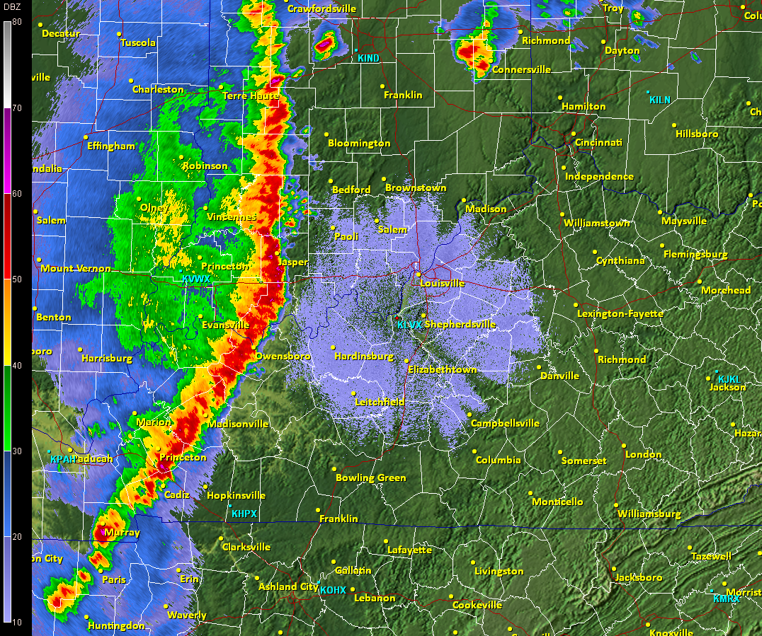
A squall line is a group of storms arranged in a line, often accompanied by “squalls” of high wind and heavy rain. Squall lines tend to pass quickly and are less prone to produce tornadoes than are supercells. They can be hundreds of miles long but are typically only 10 or 20 miles wide.
A supercell is a long-lived (greater than 1 hour) and highly organized storm feeding off an updraft (a rising current of air) that is tilted and rotating. This rotating updraft – as large as 10 miles in diameter and up to 50,000 feet tall – can be present as much as 20 to 60 minutes before a tornado forms. Scientists call this rotation a mesocyclone when it is detected by Doppler radar. The tornado is a very small extension of this larger rotation. Most large and violent tornadoes come from supercells.
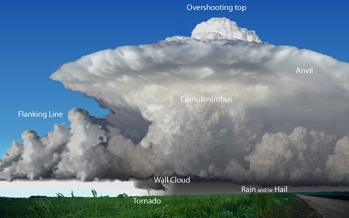
Some of the features to be found in a supercell storm. Every storm is different. Not all storms will display all of the features of a classic supercell. [+]
A “bow echo” is a radar signature of a squall line that “bows out” as winds fall behind the line and circulations develop on either end. A strongly bowed echo may indicate high winds in the middle of the line, where the storms are moving forward most quickly. Brief tornadoes may occur on the leading edge of a bow echo. Often the north side of a bow echo becomes dominant over time, gradually evolving into a comma-shaped storm complex.
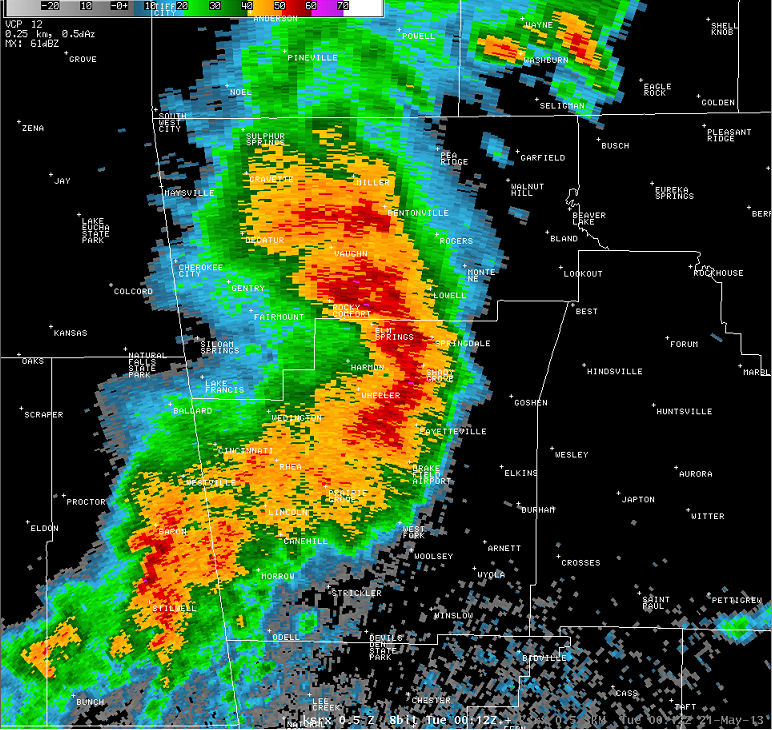
Bow echo over Springdale, Arkansas, 21 May 2013. [+]
A Mesoscale Convective System (MCS) is a collection of thunderstorms that act as a system. An MCS can spread across an entire state and last more than 12 hours. On radar one of these monsters might appear as a solid line, a broken line, or a cluster of cells. This all-encompassing term can include any of the following storm types:
Mesoscale convective complex (MCC)—A particular type of MCS, an MCC is a large, circular, long-lived cluster of showers and thunderstorms identified by satellite. It often emerges out of other storm types during the late-night and early-morning hours. MCCs can cover an entire state.
Mesoscale convective vortex (MCV)—A low-pressure center within an MCS that pulls winds into a circling pattern, or vortex. With a core only 30 to 60 miles wide and 1 to 3 miles deep, an MCV is often overlooked in standard weather analyses. But an MCV can take on a life of its own, persisting for up to 12 hours after its parent MCS has dissipated. This orphaned MCV will sometimes then become the seed of the next thunderstorm outbreak. An MCV that moves into tropical waters, such as the Gulf of Mexico, can serve as the nucleus for a tropical storm or hurricane.
![[+]](https://www.nssl.noaa.gov/education/svrwx101/thunderstorms/types/img/Milford_CT_2009-07-31_wind_damage.jpg)
A derecho (pronounced similar to “deh-REY-cho” in English) is a widespread, long-lived wind storm that is associated with a band of rapidly moving showers or thunderstorms. Although a derecho can produce destruction similar to that of tornadoes, the damage typically is directed in one direction along a relatively straight swath. As a result, the term “straight-line wind damage” sometimes is used to describe derecho damage. By definition, if the wind damage swath extends more than 240 miles (about 400 kilometers) and includes wind gusts of at least 58 mph (93 km/h) or greater along most of its length, then the event may be classified as a derecho.
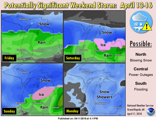
Enjoy today because we have a stormy period shaping up for Friday through Monday. This morning it is a warm 48° here in Otsego at 7am. We had .29 of an inch of rain overnight. There is a winter storm watch for the counties north of Grand Rapids and Flint which goes into effect tomorrow night. Stay tuned as the latest NAM model I ran this morning had the freezing rain moving a bit further south. In the watch area 3/4 of an inch of freezing rain may fall. Areas around Gaylord and the northern lower peninsula could see 16 inches or more of heavy wet snow. Southern Michigan could pick up 2 to 3 inches of rain. This could turn out to be a historic April weather event. We will have a better idea where and what will fall tomorrow. All in all it looks like a great weekend to stay home and read a book.
The morning forecast discussion is definitely worth a read:
https://forecast.weather.gov/product.php?site=GRR&issuedby=GRR&product=AFD&format=CI&version=1&glossary=1
Anybody see the blizzard warning west of Mi? Any thoughts on this coming here?
MV- I love squirrels but what is the best thing to keep them off of my bird feeder. I can’t keep up with him. My daughter mentioned greasing the pole (narrow one) or putting a squirrel baffle on it. Any advice would be appreciated.
No let up in sight!
http://www.cpc.ncep.noaa.gov/products/predictions/610day/610temp.new.gif
http://www.cpc.ncep.noaa.gov/products/predictions/814day/814temp.new.gif
This map show 3 ft of SNOW for Northern Lower MI! This could be an historic Spring storm!!!!!!!!!!!!!!!
http://www.pivotalweather.com/model.php?m=gfs&p=snku_acc&rh=2018041218&fh=240&r=conus&dpdt=
Another 12 inch + snowstorm for SNOW country! It looks like I will not need to drive all the way to the UP for some mid winter like snowmobiling in mid April!!!!!!
WOW the April to remember keeps going! INCREDIBLE!
http://wxcaster.com/gis-gfs-snow-overlays2.php?STATIONID=APX
I don’t like the sounds of this. From NWS GR’s 3:30 forecast discussion:
Bottom line… there is potential for a major ice storm across
south central and central lower Michigan from early Saturday
morning through Sunday morning which could result in widespread
power outages.
Lets hope it stays North!
Woah Detroit is up to 75 degrees! Summer day in April.
Looks like by about next Wednesday Mother Nature finally remembers it’s Spring in Michigan! Still a little below average then, but not 25 degrees below average like it has been all month!!
https://weather.com/weather/tenday/l/USMI0344:1:US
Very nice outside but windy! INDYDOG14!
It is so nice out. I have a jug out… hoping to make first jug of sun tea!!! LOL!!!
Seeing some 70’s in Michigan right now!
Winter storm watches could be coming for GR stay tuned INDYDOG14!!
Oh man INDY for freezing rain!!! That is not good! Get your generators ready!
It is beautiful outside this morning!! 🙂
Well the wind has taken over so much for 65* today the cold is winning out again!! INDYDOG14!!
GR is up to 63 degrees at 11am! I know some on here had expressed a doubt we’d even hit 60.
Looks like anothef cold week ahead for the middle of April!! INDYDOG14!!
Wow, 55 degrees at 9am.
At this time we are still planning on going up to the Bay City area for the weekend to visit family. At this time there is a winter storm watch up for an ice storm with not only a half inch or more of ice but winds of 35 to 45 MPH out of the north east. Having lived there for over 30 years I know first hand that under this set up the winds can be higher then that in Bay City with the fetch of almost 200 miles off Lake Huron and the Saginaw Bay. If we go… Read more »
Have a safe trip!