 What is hail?
- Hail is a form of precipitation that occurs when updrafts in thunderstorms carry raindrops upward into extremely cold areas of the atmosphere where they freeze into balls of ice. Hail can damage aircraft, homes and cars, and can be deadly to livestock and people.
- How does hail form?
- Hailstones grow by colliding with supercooled water drops. Supercooled water will freeze on contact with ice crystals, frozen raindrops, dust or some other nuclei. Thunderstorms that have a strong updraft keep lifting the hailstones up to the top of the cloud where they encounter more supercooled water and continue to grow. The hail falls when the thunderstorm’s updraft can no longer support the weight of the ice or the updraft weakens. The stronger the updraft the larger the hailstone can grow.
Hailstones can have layers like an onion if they travel up and down in an updraft, or they can have few or no layers if they are “balanced” in an updraft. One can tell how many times a hailstone traveled to the top of the storm by counting the layers. Hailstones can begin to melt and then re-freeze together – forming large and very irregularly shaped hail.
- How does hail fall to the ground?
- Hail falls when it becomes heavy enough to overcome the strength of the updraft and is pulled by gravity towards the earth. How it falls is dependent on what is going on inside the thunderstorm. Hailstones bump into other raindrops and other hailstones inside the thunderstorm, and this bumping slows down their fall. Drag and friction also slow their fall, so it is a complicated question! If the winds are strong enough, they can even blow hail so that it falls at an angle. This would explain why the screens on one side of a house can be shredded by hail and the rest are unharmed!
- How fast does hail fall?
- We really only have estimates about the speed hail falls. One estimate is that a 1cm hailstone falls at 9 m/s, and an 8cm stone, weighing .7kg falls at 48 m/s (171 km/h). However, the hailstone is not likely to reach terminal velocity due to friction, collisions with other hailstones or raindrops, wind, the viscosity of the wind, and melting. Also, the formula to calculate terminal velocity is based on the assumption that you are dealing with a perfect sphere. Hail is generally not a perfect sphere!
- What areas have the most hail?
- Though Florida has the most thunderstorms, Nebraska, Colorado, and Wyoming usually have the most hail storms. The area where these three states meet – “hail alley,” averages seven to nine hail days per year. The reason why this area gets so much hail is that the freezing levels (the area of the atmosphere at 32 degrees or less) in the high plains are much closer to the ground than they are at sea level, where hail has plenty of time to melt before reaching the ground. Other parts of the world that have damaging hailstorms include China, Russia, India and northern Italy.
When viewed from the air, it is evident that hail falls in paths known as hail swaths. They can range in size from a few acres to an area 10 miles wide and 100 miles long. Piles of hail in hail swaths have been so deep, a snow plow was required to remove them, and occasionally, hail drifts have been reported.
- How large can hail get?
- Hail is usually pea-sized to marble-sized, but big thunderstorms can produce big hail. The largest hailstone recovered in the U.S. fell in Vivian, SD on June 23, 2010 with a diameter of 8 inches and a circumference of 18.62 inches. It weighed 1 lb 15 oz.
- Estimating Hail Size
- Hail size is estimated by comparing it to a known object. Most hail storms are made up of a mix of sizes, and only the very largest hail stones pose serious risk to people caught in the open.
- Pea = 1/4 inch diameter
- Marble/mothball = 1/2 inch diameter
- Dime/Penny = 3/4 inch diameter
- Nickel = 7/8 inch
- Quarter = 1 inch — hail quarter size or larger is considered severe
- Ping-Pong Ball = 1 1/2 inch
- Golf Ball = 1 3/4 inches
- Tennis Ball = 2 1/2 inches
- Baseball = 2 3/4 inches
- Tea cup = 3 inches
- Grapefruit = 4 inches
- Softball = 4 1/2 inches
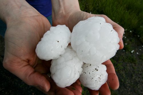
I have seen 3 to 4 inch hail and the damage it can do – not something you want to be out doors in for sure….
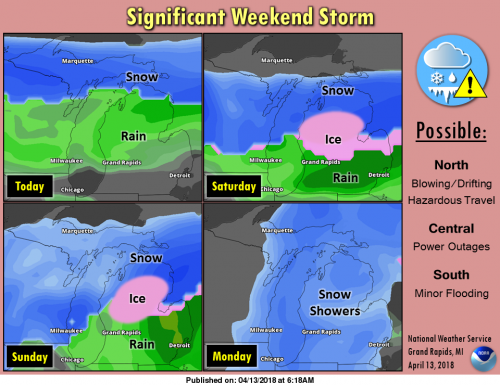
 Active weather from a slow-moving storm system is expected through Monday. Substantial disruptions to commerce and weekend activities will be possible from the snow, ice and wind, especially in central to northern portions of Michigan. Travel may become dangerous in portions of northern Michigan from heavy snow as well as blowing and drifting snow. Ice pellets (sleet) or rain freezing on contact (freezing rain) is likely Saturday into Sunday in a large portion of Central Lower Michigan. The ice accumulations and strong winds may create multi-day power outages. Grand Rapids and Lansing could become cold enough for a portion of Saturday or Saturday night for a period of freezing rain.
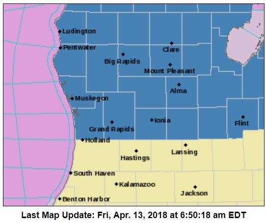
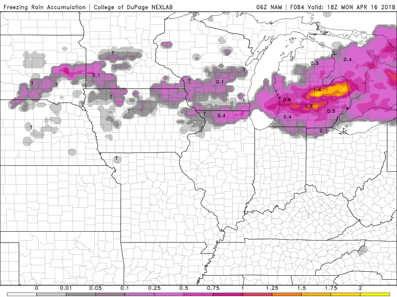
As I stated yesterday the NAM was trending the ice and sleet further south. We now have Counties from Ottawa and Kent to the east and north under the advisory through Monday where up to 3/4 of an inch of ice accumulation is possible. Quite a temperature deferential across the state for today ranging from the 60s through the I94 corridor to the south to the 30s along US 10 to the north. This could be a dangerous situation so stay tuned for later reports. Below is the NAM run at 7am this morning showing the ice accumulation through Monday.
An extended Freezing Rain event is a difficult thing to develop and maintain. Here’s hoping we get through it easily.
This could go down as one of the coldest Springs ever! Who would have thought?
http://www.cpc.ncep.noaa.gov/products/predictions/WK34/gifs/WK34temp.gif
Meh….who cares…after Tuesday temps shoot up to the 50’s and 60’s! So winter’s reign of horror looks to be over after this weekend!! THANK GOD!! The weather that you love is producing an awful ice storm this weekend! Hope it’s fun for you!
https://m.accuweather.com/en/us/grand-rapids-mi/49503/extended-weather-forecast/329374
https://weather.com/weather/tenday/l/USMI0344:1:US
Ice is the worst and I surely don,t hope for any freezing rain. Snow yes, freezing rain no!
Looks like Eaton and Ingham counties are in the bullseye for the most ice accumulation potential. Great.
I PRAY NOT!!! I will take rain/snow/sleet/hail/ whatever the kitchen sink can throw… but please NO Freezing rain 🙂 We need to do a “go away dance”. ER tends to always be the “hole” for good snow storms.. hopefully that hole works again!!
I hear ya, Sherry. I will be doing that dance too.
Quite the front! 72 degrees on the Michigan-Indiana border right now. And 36 degrees in Big Rapids.
No kidding. 44 in Chicago, 76 in Fort Wayne.
Winter storm warnings coming yeaaa in April crazzy stay tuned INDYDOG14!
Another very mild morning out! Looks like GR just missed the mid 70’s. Detroit hit 76 yesterday!
The airport on the west side of town hit 69 yesterday. My thermometer at home hit 72.
My wife and me have to go to the store and pick up some items for not only ourselves but for my wife’s mother who lives in Linwood, Michigan (about 12 miles north of Bay City) her mother lives about a half mile inland from Saginaw Bay. We have been planning a trip up there for some time now and this weekend is the weekend we had picked. Now the bad news of course there is a very good chance that there will be a ice storm this weekend over much of central Michigan. While here in Grand Rapids it… Read more »
After yesterdays “heat wave” when the temperature shot all the way up to 64° that is good for the warmest day this year so far beating out February 20th high of 63° Even with yesterdays “heat” the mean temperature so far this April is just 34.0° (-10.3°) still on tract for one of the coldest April’s on record. And looking ahead there are more much colder than average days ahead the average H/L today is 57/37 and by Tuesday it is 59/38 the forecasted highs for the next 5 days are 48,36,35,38 and 44.
Slim