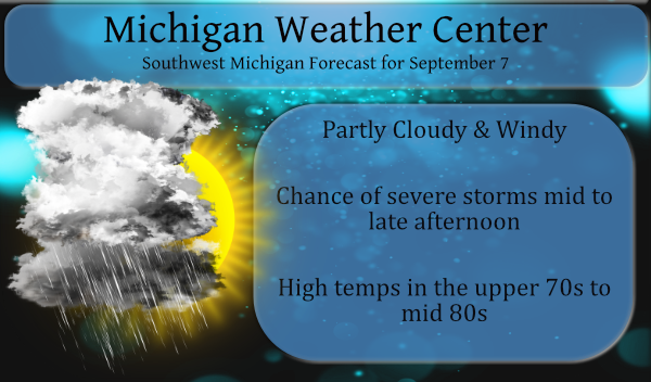
When we have calm beautiful days it is very quiet here on the blog I can hear crickets chirping in the background. When there is the mention of snowstorms or severe weather the visitations increase tenfold. A cold front will move south across Lower Michigan today triggering showers and thunderstorms as it moves through. A few of the storms may be strong to severe with damaging winds and large hail. High temps will range from the mid-70s to the mid-80s.
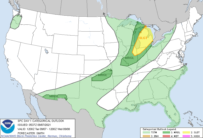
This is the latest convective outlook for Michigan:
An amplifying midlevel trough over the Great Lakes will feature a
deepening surface cyclone over Ontario.  A trailing cold front will
move southeastward across the Great Lakes during the period.  A
narrow corridor of low-level moistening is expected immediately in
advance of the front.  Elevated convection will likely be ongoing
this morning over WI/northern MI and additional storms are forecast
to develop by midday along the leading edge of the outflow and/or
cold front.  Increasing large-scale ascent will favor the
development of an extensive squall line (high confidence) from
northern Lower MI southwestward into the mid MS Valley.  Damaging
gusts will be the primary hazard with the squall line but a tornado
is possible with more pronounced inflections/bows within the squall
line.
Forecast Discussion
Slight Risk of severe weather for this afternoon and evening with
strong, unidirectional shear profiles indicating storm type will
be linear with blowing line segments bringing primarily downburst
wind threat but also QLCS tornado possibility. Tall skinny CAPE
through the hail growth region suggests any updrafts taller than
30 kft will have large hail threat as well.

Timing of the storms on most of the forecast guidance suggests
arrival time at or before 18Z across the far northwest forecast
area near Ludington and Manistee with the line of storms sagging
southeast and reaching Grands Rapids and Lansing around 20Z and
Jackson by 23Z. The storms should clear the forecast area by 03Z.

Environmental winds are strong with 40 to 50 knots near 5 kft AGL
and some of this could mix down in the cold air advection behind
the cold front, but more likely in any solid line of convection
along or ahead of the front. Dry adiabatic sub cloud layer could
also enhance downburst potential.

Scattered showers will persist on Wednesday under upper troughing
with diurnal and lake enhancement in the cool air. The trough
axis moves east with surface ridging moving in for Thursday with
temperatures tumbling into the 40s most places on Thursday night.

Quasi-zonal flow regime with embedded shortwave troughs follows
into the weekend with a chance of showers on Saturday and again
early next week.
For information purposes, the term QLCS stands for ‘Quasi-Linear Convective System’. These are tornadoes that form very quickly with little warning. They ‘spin up’ with a line of storms often called a squall line. I suspect these storms will move through SW Michigan after 4 pm. The front will produce a quick shot of storms with heavy rain and then be gone by evening,
Our high temp yesterday was 75° and our current temp this morning at 5:30 is 52°.
Sunrise today is 7:15 and sunset is 8:06 pm today.
Well, a whopping total of 0.06” of rain here and no wind at all. Maybe next time.
Severe thunderstorm warning here. Light to moderate rain for about ten minutes. Hardly any wind. But, righteous CTG lightning
We had pouring rain and lots of wind. I didn’t see any lightning but we had thunder.
It’s amazing what a couple of miles can mean in what you get in the weather.
The NWS GR radar is not working right now. It was hit by lightning.
We may be going to the MSU football game Saturday. The weather looks great – 82 and partly cloudy.
The fizzle is in full effect. The warnings one county over have expired and there’s a big hole in the line developing off to the west.
The next two weeks looks to be more of the same – average to above average, mid 70s to low 80s.
Wow storms missed my area again but Temps have fallen in to the 60”a who would of thought?? INDY..
The result was known hours ago. ADA has survived SEVERE light rain.
Wow, two times in a row now. Nice line of storms heading straight at us only to fall apart and a new line forms 2 miles East of us. Jumped right over this area again!? Someday I’d like an explanation as to what exactly happens here. I’ve observed this “phenomenon” many times over the years.
Probability of Watch Issuance…60 percent SUMMARY…A severe thunderstorm watch may become necessary in the next 1-2 hours across southern Lower Michigan and northern Indiana. Damaging winds and large hail are the primary threats, though a conditional threat for a tornado also exists. DISCUSSION…Surface heating continues across southern Lower Michigan and adjacent Indiana. With dewpoints mixing out into the upper 50s F, surface-based destabilization has been muted. Additional surface heating and cooling aloft as the upper trough approaches should allow for greater buoyancy to develop, particularly in the vicinity of the cold front. Damaging wind gusts and large hail are the… Read more »
Heated up quickly today. 85 here with dewpoints only in the 60s. With the breeze, it is bearable. Looks like most of us should get some action this afternoon/evening. I would be happy with some rain at this point. Then again, the growing season is mostly over at this point. I’m only needing to mow every ten or so days.
I see that the Chicagoland area is now under a severe thunderstorm watch. It would seem that we will be added to the watch soon.
Sadly…we already know the outcome of this “storm event”…maybe we’ll see some beneficial rainfall.
There is now a server Thunderstorm watch for GRR and to the north
Slim
Here is the watch area
https://www.spc.noaa.gov/products/watch/ww0488.html
Slim
Rain is welcome
.UPDATE… Issued at 1015 AM EDT Tue Sep 7 2021 There are currently 2 lines of thunderstorms heading this way. The first line, which currently is from near Manistee to Gaylord is expected to head east and not impact much of our CWA, as there already an outflow boundary ahead of it. A second line of storms, which based on LSRs from GRB, there has been baseball to tennis ball size hail will be the primary line of storms. The mid level lapse rate this afternoon is over 7c so large hail is more than possible. The near unidirectional wind… Read more »
Bring on the rain! Hopefully our rain chances won’t fizzle this afternoon! We are in a great cool weather pattern! Keep it rocking!
Perfect weekend weatherwise and a great start to the college football season. Have a great week, everyone!
It has been very dry the last 25 days so we could use some rain. At this time there are some storms over northern Lake Michigan and part of the UP. Here it is clear and a rather cool morning the overnight low here and officially at GRR was 53. At this time with the clear skies it is 55.
Slim