
This is great bread-baking weather – yes, I can bake bread also. With the cold weather upon us it is nice to have the warmth of the oven and the great smell of artesian bread smells in the house.
Lake effect rain was dominant yesterday along the lakeshore counties. We had 1.5 inches to add to the 2.61 inches to our monthly total of 4.11 inches all in three days. Yesterday’s high was 51°. We currently have 38° at 5 a.m.

Parts of the area have seen quite a bit of rainfall since late Wednesday. The heaviest amounts were between Grand Rapids and Kalamazoo where a little over 4 inches has fallen.
SW Michigan Forecast
U.S.A and Global Events for October 8th:
1871: The Great Chicago Fire burns much of the city to the ground, fanned by strong southwest winds. An estimated 250 were killed. On the same night, forest fires swept through Peshtigo, Wisconsin. An estimated 1,500 to possibly as many as 2,500 die as gale-force winds push flames across town. Severe drought blamed for tinder-dry conditions. Click HERE for more information from the NWS Office in Green Bay, Wisconsin. An additional 200 die in Michigan fires.
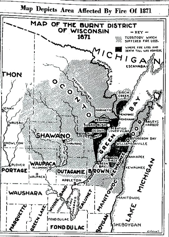
The image above is courtesy of The Sheboygan Press, Oct. 8, 1929.
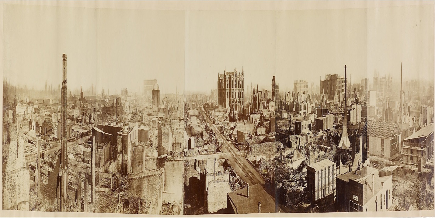
Panorama of Chicago after the 1871 Fire. Attributed to George N. Barnard (1819 – 1902), an American photographer. Click HERE for more information from the World History Project.
1878: An estimated F3 tornado struck Monticello, Iowa, around 5:30 p.m. The Catholic Church was demolished, along with several homes. The business portion of the town was comparatively uninjured. While no lives were lost, 11 people were injured. The German Church in Richland township was destroyed, along with other buildings in the surrounding county. A wind and hail storm occurred during the evening hours in Sigourney, Iowa, causing considerable damage. Fences and shade trees were blown down, and much glass was broken by hail, which fell in large stones. Click HERE for a newspaper account of this storm.
1919: An intense tornado moved through the town of Hoisington, 11 miles north of Great Bend, Kansas. It damaged or destroyed 60 homes which resulted in $200,000 in damages. Business papers and canceled checks were found at Lincoln, 55 miles to the northeast. Click HERE for a photograph from Kansas Memory.
1946: A minimal Category 1 hurricane made landfall over Bradenton, Florida, before tracking north-northeast across Tampa Bay. The storm was the last hurricane to make direct landfall in the Tampa Bay area. Click HERE for more information from NOAA’s Hurricane Research Division.
Forecast Discussion
Satellite/radar shows clouds persisting southwest of Grand Rapids in
the traditional northwest flow lake effect belt area, along with a
few showers, while areas north and east of Grand Rapids have cleared
out. Overnight lows fall into the mid 30s so some patchy frost can`t
be ruled out in the eastern half of our forecast area though
slightly elevated winds just off the surface look to mitigate the
potential for more widespread frost formation.

Clouds increase again Sunday as continued lake effect driven cloud
formation persists with the upper-low still overhead. Lake effect
rain showers expand inland during the day as diurnally driven
instability increases. Areas of patchy frost again can`t be ruled
out inland Sunday night in areas with prolonged clearing however
clouds look to prevent widespread frost.

Moving into Monday the main forecast concern is precipitation
chances associated with a retorgrading low-pressure system to our
northeast. Majority of the precipitation with this system looks to
fall north of the CWA. However, some showers could make it down into
our northern CWA where our highest POPs are. Any precipitation would
be under 0.1 inches. Plenty of cloud cover is expected across the
CWA Monday.

The long term period will be very fall like with cool temperatures,
plenty of cloud cover and precipitation in most forecast periods.

Monday night the upper low will be overhead which will essentially
continue to be the case into mid week. The upper low though will be
moving slightly off to the north and east with time, losing a bit of
its influence on our area weather. We have chances for rain showers
in the forecast Monday night into Tuesday and then carry a dry
forecast for Tuesday night as the surface pattern will essentially
evolve into a col.

That dry forecast period Tuesday night is essentially the only 12
hour period of the long term when we do not have precipitation
chances in the forecast. Wednesday afternoon into Thursday night a
surface warm front will be situated just off to our south bringing
high chances for rain. The surface low will be moving through the
region Friday into Friday night with the high chances for rain
continuing. An upper low settles into the area into the weekend with
more chances for rainfall.

The WPC 7 day qpf forecast for Southwest Lower Michigan has 2 to 4
inches of rain across all of the southwest quarter of Lower
Michigan. If those type of totals verify, which is not a given at
that range in the forecast, we would be looking at some rivers
reaching action stage (bankfull) and the possibility of a few
locations approaching flood stage. Plenty of time to watch trends in
the forecast and dial in amounts. So, at this point we are in a
monitor phase with respect to 7 day precip totals.
Got down to 36 here this morning with some patchy frost in the shade. The sun this morning is very nice, and with the light winds, it’s actually not too bad out.
Went for a run yesterday and got stuck in a lake effect band. Was definitely refreshing to say the least
How have I not heard of the Wisconsin fire? Perhaps overshadowed by Chicago. Regardless, that’s a massive loss of life and an enormous amount of acreage.
I really need to mow today. It is still quite soggy out there. Feels nice this morning. It’s finally hoodie weather! I changed the furnace filter and tested the smoke alarms it’s kinda ceremonial. 😄
The official H/L yesterday at Grand Rapids was 55/41. There were numerous lake effect rain showers that dropped 0.13” of rain fall. There were 17 HDD’s the highest wind speed was 31MPH out of the NW. the sun was out 34% of the time. For today the average H/L is 64/45 the record high of 88 was set in 2007 and the record low of 28 was set in 1989. The record rain fall amount of 1.00” fell in 2021. There have been several years with a trace of snow fall.
Slim
With a official low of at least 38 the overnight was the coldest low at Grand Rapids since May 26. Here in MBY the overnight low was 36 with clouds there was no frost. At the current time it is cloudy and 37 here in MBY.
Slim