We finally broke out of our dry spell in SW Michigan. With last night’s system and cold front, we received 1.76 inches of rain which brings us to 3.99 inches for the month which is close to the total we received all of spring. This will have a big impact on the drought conditions and erases a good chuck of our precipitation deficit for the year.
We had thunderstorm warnings for a large chunk of southern Michigan last night and a confirmed tornado touched down near Coldwater. Some structural damage was reported, along with a dozen downed trees. As of 6:00 am Consumers Power reported the following outages:
- Branch County: 2,328 outages
- Calhoun County: 1,189 outages
- Kalamazoo County: 445 outages
- St. Joseph County: 668 outages
- Van Buren County: 612 outages
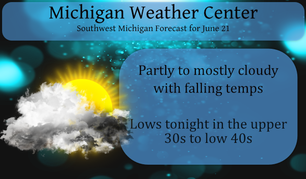
The big story for today is the unseasonable temps coming our way. It will be mostly cloudy today with temperatures falling from the 60s to the 50s as a strong cold front moves through. Tonight will be cold with scattered frost across north-central Lower Michigan. Lows will be in the 30s and 40s.
Forecast Discussion:
- Scattered showers lingering into this morning

Large area of convection is moving east and out of the forecast
area early this morning with scattered to isolated thunderstorms
along and ahead of the sfc cold front persisting through the
morning. Drier air arrives for the afternoon with sharply cooler
temperatures.

- Cold with scattered frost Tonight

Sharp upper trough will bring a shot of Canadian air with the MAV
guidance forecasting a low of 34 at CAD for Tuesday morning.
Expect some scattered frost across the cold spots in our northern
zones. Moderating temperatures expected on Wednesday as southwest
flow develops on backside of Canadian high pressure.

- Storms/heavy rain possible by the end of the week

Return flow moisture pools ahead of the next cold front with
showers and thunderstorms expected by Thursday night into Friday
as the front pushes into Lower Michigan. The main threat appears
to be heavy rain with p-wat values up to 1.9 inches and a slow
moving front providing low level convergence with training of
convection possible.
56* degrees in my area not sure if I have ever ran the furnace during the end of June but …..INDY
Get your furnace revved up! You will need it tomorrow morning!
The NWS is still hyping rain for Friday! Incredible!
This from the Grand Rapids NWS office. “WHILE WE DO NOT EXPECT A WIDESPREAD FROST OR FREEZE TONIGHT IT SEEMS LIKELY THERE WILL BE PATCHY FROST OVER OUR NORTHERN FEW ROWS OF COUNTIES, INLAND OF LAKE MICHIGAN. THE CENTER OF THE SURFACE HIGH STAYS WELL SOUTH OF MICHIGAN THE CORE OF THE POLAR JET IS SOUTH OF MICHIGAN TONIGHT, THOSE TO FEATURES WOULD SUGGEST SOME MIXING WILL STILL HAPPEN TONIGHT PREVENT TEMPERATURES FROM FALLING AS MUCH AS THEY WOULD HAVE OTHERWISE DONE. ON THE OTHER HAND THERE IS ENOUGH DRY AIR MOVING IN FROM THE CANADIAN SHIELD TO CLEAR THE… Read more »
I didnt realize we could still have temperatures this cold so late in the season? It surprises me how, if there was little to no mixing, temperatures could have reached 32 or colder (on June 21st!).
According to the MSU weather station in Grand Junction they recorded 1.42 in April and .82 in May. This June rain is much needed.
We are in southern Allegan County. Last night got just a little over 2″. That makes it 5.5″ for the month. About 3 miles to the southwest of us in Grand Junction is a MSU weather station. Very sophisticated. Recorded 1.63 last night which makes a total of 4.24 for the month.
Is it June or September outside?? INDY
Even with the overnight “high” of 69 this will be the coldest June 21st high since 2001 and only the 12th time it has not reached 70 on this date here in Grand Rapids. Once again this has been a year of some extremes both cold and warm.
Slim
Incredible June COLD! Who would have thought?
The temperature has now dropped down to 62 with cloudy skies. No matter what happens the rest of today the high will be at least 69. But that said if it stays below 69 the rest of today it will be one of the rare summer days when the high for the day was before sunrise. We have had several such days this past spring while common in the winter season this would be rare to happen in June.
Slim
Obviously, southern Allegan County and to the south has been in the sweet spot for rain the past few days, especially the Otsego/Plainwell area which has been long overdue.
Kalamazoo county received 1.00 to 1.31 inches
Colon in branch county received 1.95 inches
Berrien County received 1.33 to 1.88 inches
Constantine 1.9 and Three Rivers 1.25
Our high for the day was 67 with temps falling all morning – we are currently at 60 degrees.
Incredible late June cold is here! Lows tonight in the low 40’s! Wow! Highs the next 2 days in the 60’s! Incredible!
The temperature is dropping here now and is now down to 63.
Slim
Phew! Only 5 cool days the first 20 days of June.
First off I am glad that no was was hurt in last nights storms to the south of GR. Now as for here at my house. While there was some rain here only 0.25″ fell at my house. The storms were to the south of here and while there was some lightning off to the south there was not really a “storm” here. There was more rain at the airport as they reported at least 0.62″ Muskegon only 0.06″ Holland 0.26″ Ionia 0.32″ Kalamazoo 1.05″ and to the east at Lansing 0.58. The overnight low here was 65 and at… Read more »
I see the NWS is already hyping a heavy rain event for later this week!
The drought continues!
This storm was a total bust and one of the worst over hyped misses ever! A whopping .15 inches of rain and this after the estimated point forecast totals a day before the event was 1 to 2 inches and the day of the event .75 inches! What a joke and this rivals the big snowfall forecast misses during the winter! Incredible!
The rain was close, but pretty much all missed us. 0.08” with the first batch and 0.12” overnight for a whopping total of 0.20”.