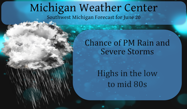
Happy Fathers Day!
The summer solstice begins tonight which means we will begin the slow march towards losing seconds then minutes of daylight.
The big concern for today is the chance of storms this afternoon and tonight. We have had 1.98 inches of rain the past couple of days which has helped ease our drought and according to the latest forecasts, we may see another one to two inches (or more) late this afternoon into the overnight hours which will make a big dent in the dry soil conditions. My grass and gardens greatly prefer rain over well water.
The latest outlook from the SPC gives us a 5% chance of a tornado within 25 miles of any one location and a 30% chance of damaging winds. There is also a 15% chance of hail. The enhanced risk of severe weather pretty much runs along and south of I96.
[columns] [span6]
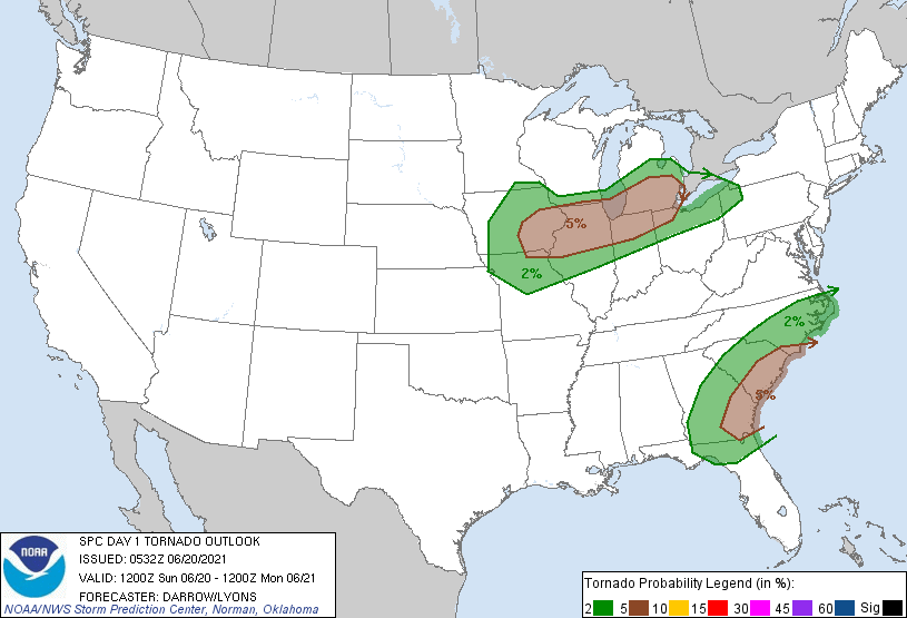
tornado outlook
[/span6][span6]
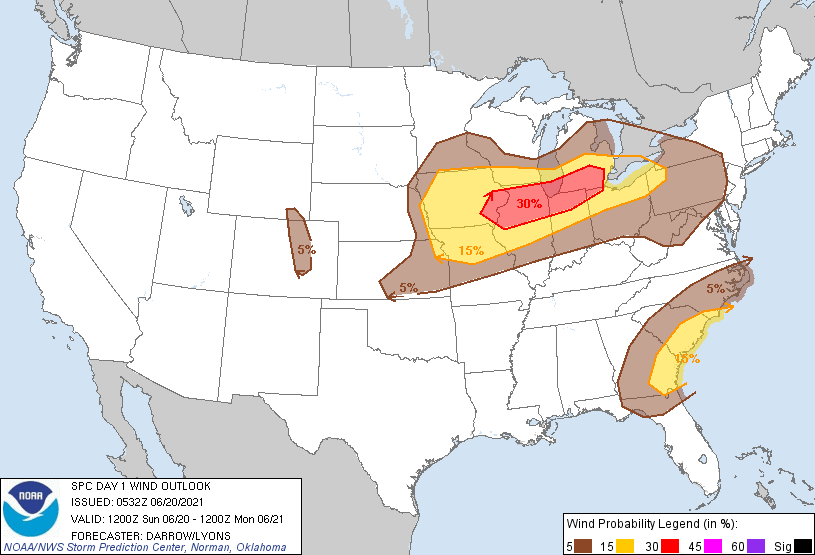
strong wind outlook
[/span6][/columns]
This is the outlook from the NWS
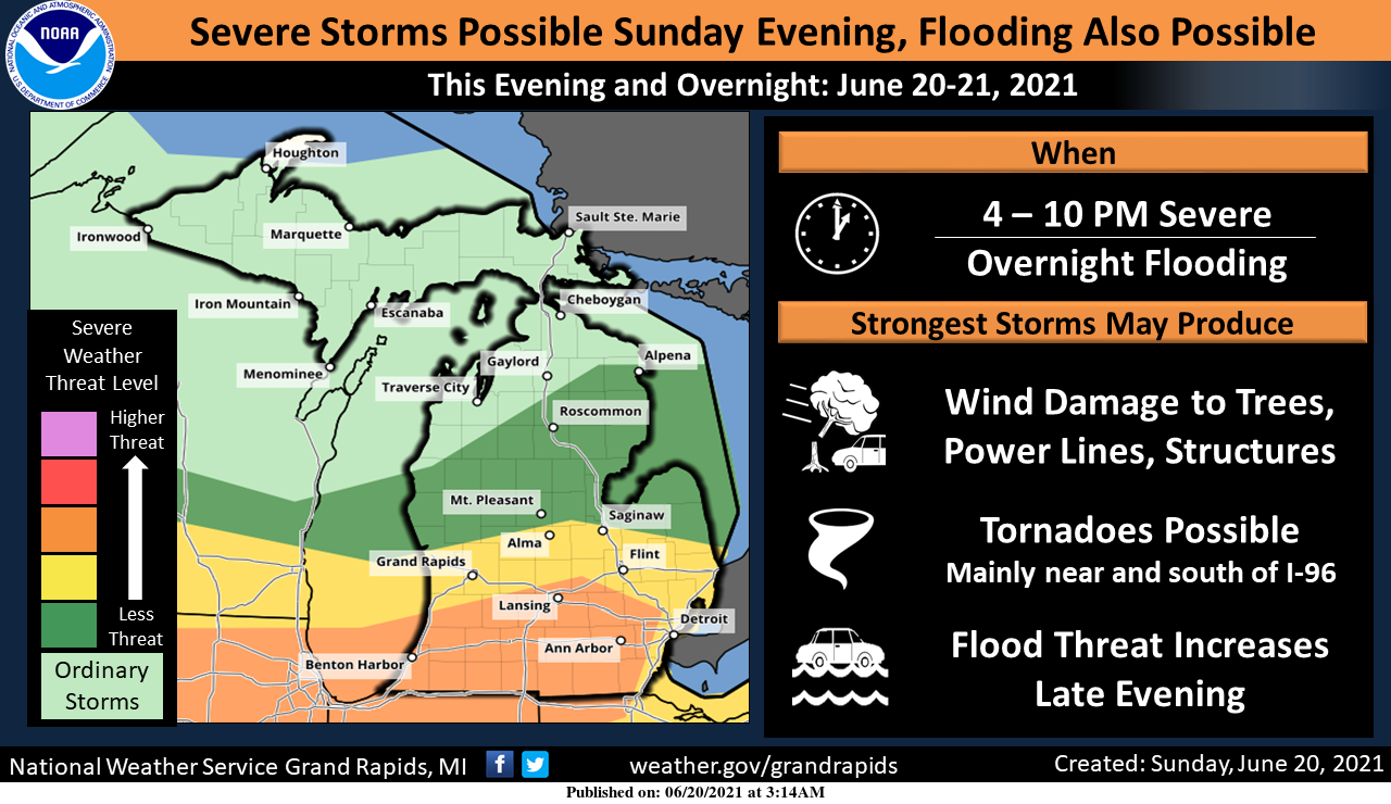
Severe thunderstorms are possible across Lower Michigan this evening, especially near and south of the I-96/I-69 corridors. Damaging wind gusts, large hail, a few tornadoes, and flooding are all possible. The flood threat will continue overnight as additional storms containing heavy rain develop.
Forecast Discussion
- Severe weather threat this afternoon and evening

Looking at the synoptic scale, we see an upper trough over
southern central Canada amplifying and eventually going
negatively tilt as an unusually strong for this time of year sfc
cyclone spins up across the Great Lakes and moves into Canada
while still deepening. This results in strong shear profiles with
nearly 50 knots of deep layer shear late this afternoon into this
evening.

On the mesoscale, a cluster of thunderstorms currently entering
western Iowa is forecast to propagate east-northeast today, cross
southern Lake Michigan during the late afternoon, then enter
central/southern Lower Michigan around 6 pm. The late afternoon
timing is much better for severe storm potential than yesterday`s
early morning convective overturning that the atmosphere was
never able to fully recover from across our forecast area. Model
forecast soundings show 3000 J/kg CAPE at AZO by late afternoon
along with over 50 knots of 0-6 km shear by early evening.

Damaging wind threat will exist with any strong updraft and
linear convection may be preceded or accompanied by persistent
mesocyclones with the tornado threat greatest in the area of the
sfc warm/stationary front, which is expected to be somewhere
between I-94 and I-96 by early evening.

The main batch of storms will be moving off to the east by
midnight but additional thunderstorms ahead and along the eastward
moving cold front will continue into the early morning hours of
Monday. Given the precipitable water values near 2 inches and the
expected training of storms across the I-94 corridor where 1 to 3
inches of rain fell on Saturday, there could be some local
flooding of streams and some urban areas despite the antecedent
drought conditions.

- Cold with scattered frost Tuesday morning

Sharp upper trough will bring a shot of Canadian air cooler than
that of last week, with the MAV guidance forecasting a low of 34
at CAD for Tuesday morning. Expect some scattered frost across
the cold spots in our northern zones. Moderating temperatures
expected on Wednesday as southwest flow develops on backside of
Canadian high pressure.

- Storms possible by the end of the week

Return flow moisture pools ahead of the next cold front with
showers and thunderstorms expected by Friday as the front comes
through. Plenty of time to assess potential for severe or heavy
rain with this slow moving front.
I could care less about a severe thunderstorm, I just want more rain!
About 10 drops of rain so far! What a joke! Hopefully the next batch hammers us! We could use at least another inch of rain, however so far this is a total dud and an over hyped event!
HAPPY FATHER’S DAY!! i HOPE YOU ALL HAD A GREAT DAY! It is just starting to rain here. I was so glad it held off till we were done with our cook out and getting together with family. I don’t know how warm it got today but the clouds did help keep the heat down.
It was 85 here and a bit humid. Mowed the lawn this morning and then we had dinner with my dad. Just got home and lots of lightning and thudded heading my way. Bring on the rain!
Where is all of this so called rain? They keep lowering the rainfall estimates for GR! Will we even get 1/2 inch tonight? Also GR will not be seeing any severe thunderstorms tonight! Mark it down!
Our routine “swing, and a miss”…enjoy the rain Ludington & North.
You know it!
Happy Father’s Day!!!
MD upstream:
https://www.spc.noaa.gov/products/md/md1032.html
Latest NWS Discussion: Looking at the severe weather threat tonight, I am in total agreement with SPCs 757 am discussion... "Predictability does not always improve closer to an event, and this is an example. A messy, conditional and very mesoscale-dependent scenario is evident, with convective trends from the prior overnight to this morning only augmenting the uncertainties." The big issue to me is the MCV that has developed and still lives, as it moves east- northeast, it has a large cool pool with it and it may push the frontal boundary farther south, so the stronger surface convergence with the… Read more »
Maybe we get a bit more rain…”real” storms?…honestly. Half way through June and the forecasting is cold, frost/freeze, followed by more cold? Oh well…maybe next year.
Phoenix as of yesterday has had 8 days in a row of 110+ and 5 days in a row of 115+ so far in the month of June they there has only been 1 days of less then 100 and that day had a high of 99.
Slim
Happy Fathers Day! We will have to see how todays possible storm event plays out. The overnight low here was 58 the official overnight low at GRR was 59. At this time it is clear and 71 here at my house.
Slim
Pulled out my generator to make sure it starts just in case – haven’t had to use it in three years or so… started up on the third pull of the cord – yaaa!
Wow, the one day we pick to go up North for the day looks like there will be a lot to watch around here. Happy Father’s Day to all the fellow fathers here!