We have a cool start for this morning, temp is 42° in Otsego, 44 in Kalamazoo, 39 in Grand Rapids, 31 in Baldwin – well you get the picture. (These are temps from the Ambient Weather Network).
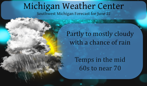
We have another cool day in store, Clouds will be on the increase this morning. A few showers will develop toward the afternoon, with a rumble of thunder possible up north. Highs will be around 65 to 70 degrees. This makes great weather for those who work outside all day for a living.
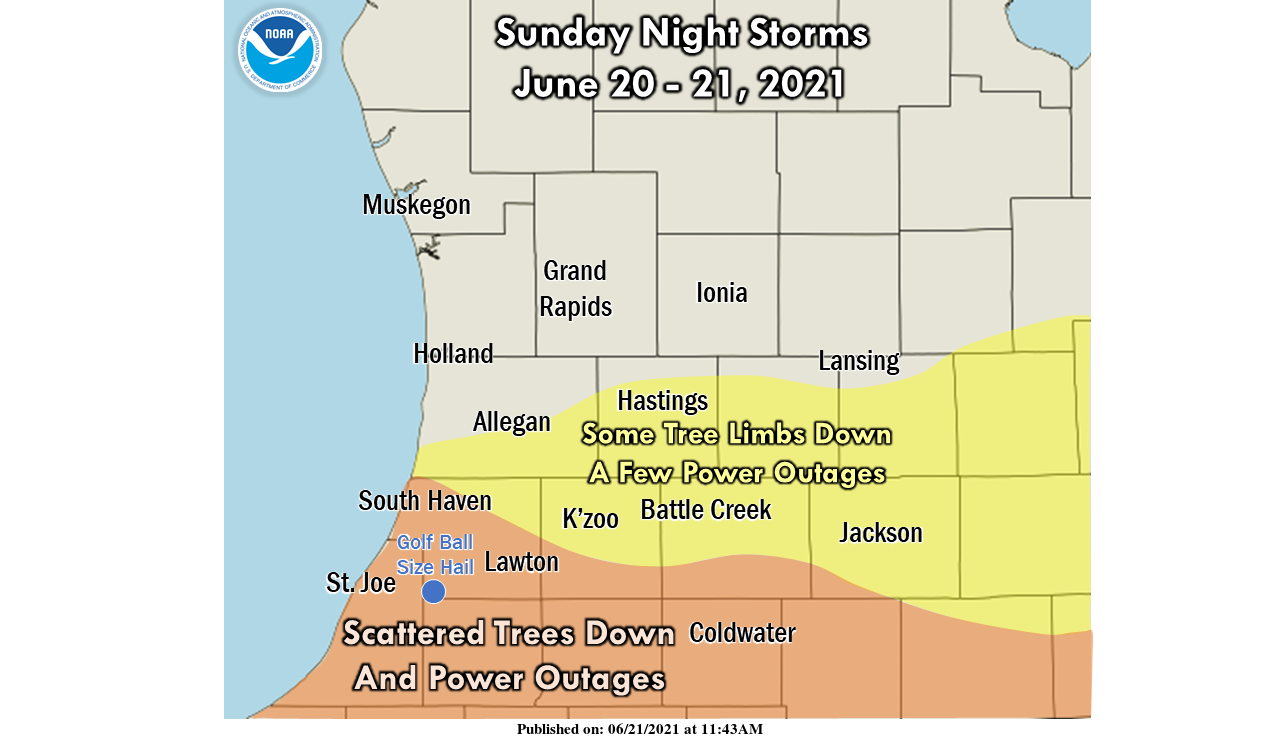
Two rounds of severe thunderstorms moved through Southern Michigan Sunday evening and overnight. The hardest-hit areas include Van Buren County and the counties bordering Indiana and Ohio, where there were a good number of locations that had trees down and power outages. In most if not all cases, the damage was due to strong wind gusts which accompanied the heavy rain. Tornado warnings were issued in some locations which had rotating storms on radar and/or spotter reports of funnel clouds. NWS is working with county emergency management agencies to find any concentrated areas of damage with signatures that provide evidence of a tornado.
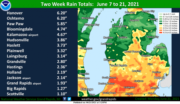
Two weeks of scattered thunderstorms with heavy downpours have yielded some big totals: 2 to 6 inches of rain in a fair portion of Southwest Michigan. Not quite so much between Muskegon, Cadillac, and Traverse City, including in the Manistee National Forest.
Forecast Discussion
- Scattered Thunderstorms Today

Unseasonably strong shortwave trough axis approaches Lower
Michigan this morning with vort max rounding the base. Model
soundings show mid-level lapse rates providing potential for some
low-topped convection developing by noon. The freezing level is
around 5 kft today so, even though the updraft depth is expected
to be limited...at least pea-sized hail is possible with
thunderstorm updrafts. The storms should decrease by late
afternoon with the trough axis moving east and diminishing
insolation.

- Potential for Heavy Rain Late Week

Still looking at a slow-moving front being the focus for
convection by Thursday night into Friday or Saturday. Deep
moisture pools ahead of the front with precipitable water over
1.8 inches. Training of heavy rain could cause localized flooding
by late Friday. Given the recent rains, this event could finally
result in some rises on the mainstem rivers where heavy rains have
occurred recently such as the St. Joseph and Kalamazoo river
basins.
I see the nws is at again! My point forecast gives me 1.5 inches of rain on Friday! Ya right and the World is flat, right?
Incredible cold!
Yesterdays rain, and our light shower this morning, has left Ada with an additional 4/10 of an inch. Every little bit helps.
Getting a moderate shower here now and the temperature has now dropped down to 62.
Slim
Update on overnight lows. The official overnight low at GRR was 41 that is the 2nd coldest low for any June 22nd there were reports of a low of 39 but they are not official so that will not go into the record books. There was a official low of 30 at Cadillac. The overnight low here at my house was 42. At this time it is cloudy and 64 here at my house and the last reading at Grand Rapids was also 64.
Slim
39* degrees in my area close enough crazy ….Not even 65* yet as of 3pm that’s even more crazy wow to the wow ….INDY
With no big heat in sight this morning’s low of 39* degrees maybe the talk of Summer pretty rare for the end of June but whoe’s complaining right??? Shuuuuu …INDY
Well we sure are off to a cold start to the calendar summer. First off yesterdays official high of 69 at Grand Rapids was set at 1:33AM it is hard in the summer time to have the high set before sunrise. I will try and see if I can get any information on that from the NWS. That high of 69 was the 12th coldest high for any June 21st at GR. So during the day it was one of the coldest daytimes for the date. Now if that reported low of 39 at Grand Rapids is correct then that… Read more »
What record cold temperatures this morning for the end of June ?? NO WAY or should I say GREAT SCOTTY!! INDY