
We have another wet system moving in today with the winds picking up from the east. The heaviest rain is expected tonight through Saturday with an inch and a half or more expected.
Forecast
U.S.A and Global Events for October 13th:
1983: Severe weather in Falls Church, VA, produced 2-3 tornadoes and caused $1 million in damages. Click HERE for more information from The Washington Post.
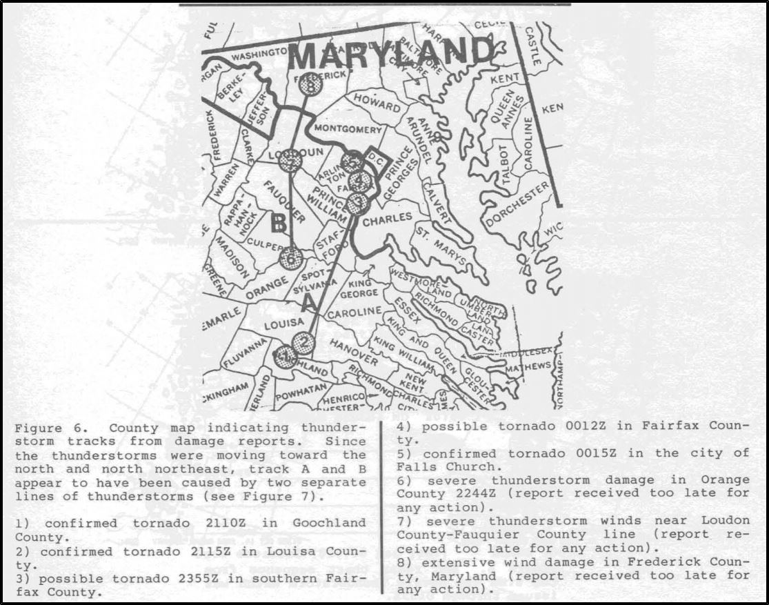
The image above is from the National Weather Association.
2006: The October 2006 Buffalo storm was an unusual early-season lake effect snowstorm that hit the Buffalo, New York area, and other surrounding areas of the United States and Canada. Downtown Buffalo reported 15 inches from this event. Depew and Alden record 24 inches, the most from this lake effect storm. Click HERE for more information from the NWS office in Buffalo.
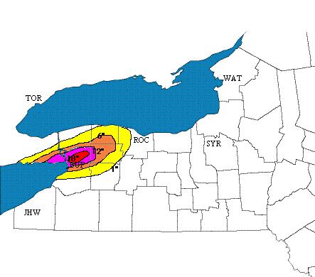
The image above is courtesy of the NWS office in Buffalo, New York.
2011: Three tornadoes hit central and Eastern Virginia on this day. One of the EF1 tornadoes caused damage to the Sylvania Plantation home that was built in 1746. The storm peeled the roof off the house.
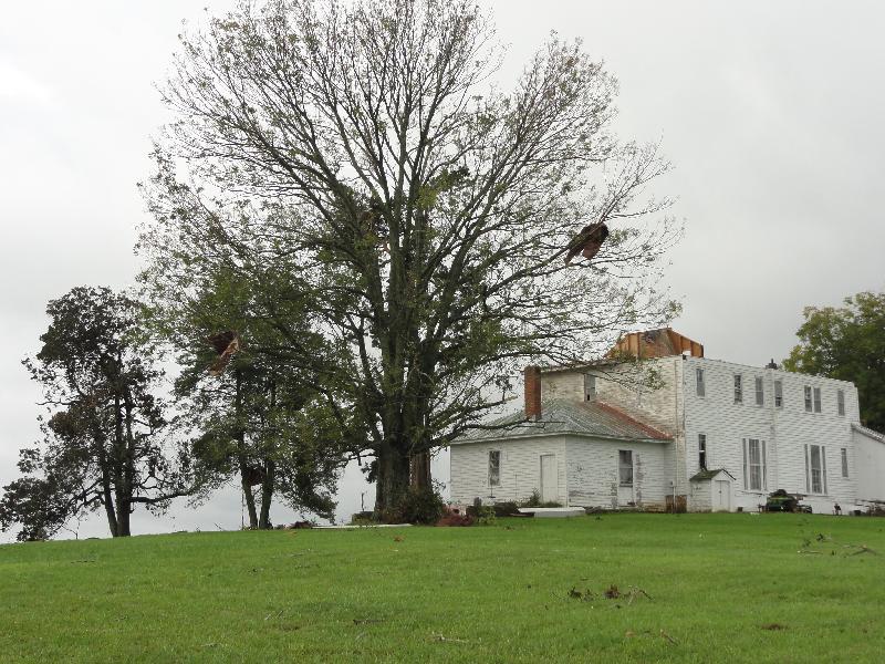
The image above is the Sylvania Plantation home. The image is courtesy of the NWS Office in Wakefield, VA.
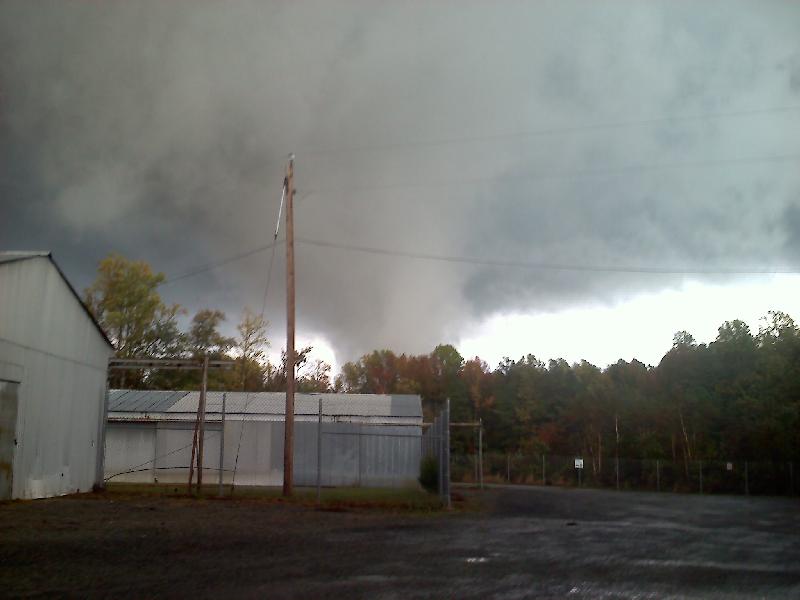
The image above is courtesy of the NWS Office in Wakefield, VA. Click HERE for more information.
Forecast Discussion
-- Showers overspread the region Today into Saturday --

Latest radar shows steady bands of precipitation continuing to
stream through Lower Michigan with the strongest bands north of I
96. As a large upper level low moves through the midwest it will
bring increased of precipitation with showers overspreading the
region late this afternoon and overnight into Saturday. Best
moisture will be with the isentropic lift as it strengthens
through the daytime. PWATS will peach above an inch this
afternoon. This is also indicated with saturation through the mid
levels. Strong short wave will be accompanied by a strong pressure
gradient from the approaching low. Latest models continue to show
elevated instability advecting into the area tonight into
Saturday. Especially with the advancing moisture columns. Expect
rainfall to be heaviest Friday night into Saturday morning. Total
QPF from Today through Saturday remains in the 1.5 to 2 inches
range with the heaviest amounts along the lakeshore. Given the
instability, we could see a few elevated storms around, especially
along and south of the I 94 corridor.

WPC guidance continues to show the area in a marginal risk for
excessive rainfall. Rivers have been low so so they shouldn`t have
issues handling this rainfall given the relatively lower amounts
basinwide. Ponding on roadways in heaviest rainfall is possible.


-- Continued Showers with Gusty winds Saturday --

As the upper level low opens up it will bring strong easterly
flow through the region Saturday. The before mentioned showers
will move eastward. However in their wake will be strong winds
which will continue through the most of the day Saturday. Expect
winds to mix down with 30 to 40 mph winds possible. On the north
side of this low is a trough which will drop cold air into the
region. This will make it difficult for highs to reach above 50.
So cold air advection accompanying widespread rainfall will
continue to sweep through lower Michigan on Saturday. While the
highest rainfall will have occurred early Saturday expect rain to
linger into the early evening hours.

Drier weather is expected Sunday/Monday in the wake of the departing
cyclone but brisk northerly winds and upper troughing will keep cool
temperatures in the 50s and considerable cloudiness in place.

H8 temps near 0C will support lake effect rain showers but most of
these will be right along the coast or just offshore. Some of the
Lake Huron lake effect could clip the LAN/JXN areas at times,
especially Sunday night/early Monday when a sfc trough drops south
through the GrtLks Rgn.

Sfc and upper ridging arrives for Tuesday/Wednesday and we may be
looking at a frost threat both Monday night and Tuesday night
if/where any decent clearing takes place. Freezing temps even
possible in the far north.

The approach of another upper trough Wednesday night/Thursday as
shown by the ECMWF brings our next chance of showers. This is in
stark contrast however to the slower/less progressive GFS and
Canadian solutions which keep ridging and dry weather in place
during this time; digging that upper trough farther west. Either
way, temperatures will return to closer-to-normal values toward the
end of next week, possibly even trending above normal.
Clouds, rain, wind and below normal temps! Incredible!
We’re in TC. Gloomy and drizzly here too. The color is underwhelming here. It was pretty good between Mesick and Cadillac, though.
It’s been quite the gloomy pattern. Hopefully the GFS is right with sunnier weather ~6 days from now… we will see.
Also I see it snowed out on this date last year. That’s definitely one of the earlier dates for sure
Happy Friday the 13th!!!
That is my lucky day! I may buy a lottery ticket!
Wow, what a pattern! Day after day with below
normal temps and now rain and wind! Incredible!!
Welcome to Friday the 13th The official H/L yesterday at GRR was 59/43 there was 0.05” of rain fall before midnight. There were 14 HDD’s the highest wind gust was 20 MPH out of the E. There was 7% of possible sunshine. For today the average H/L is now down to 62/43 The record high of 87 was is 1975 and the record low of 24 was in 1993. The record rain fall amount of 1.35” fell in 1969 the record snow fall of 01.” Fell in 2006. Last year the H/L was 53/38 there was 0.19” of rain fall… Read more »