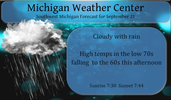
Changes are in the air (literally). We have a warm 72° this morning at 5:30 – enjoy it because it is only going downwards from here. We had .04 of an inch of rain yesterday which brings us to .20 for the month with promises of more today. The higher amounts of precip will fall in the east and southeastern parts of the state where there is a flood watch beginning at 2 pm lasting through Thursday morning.
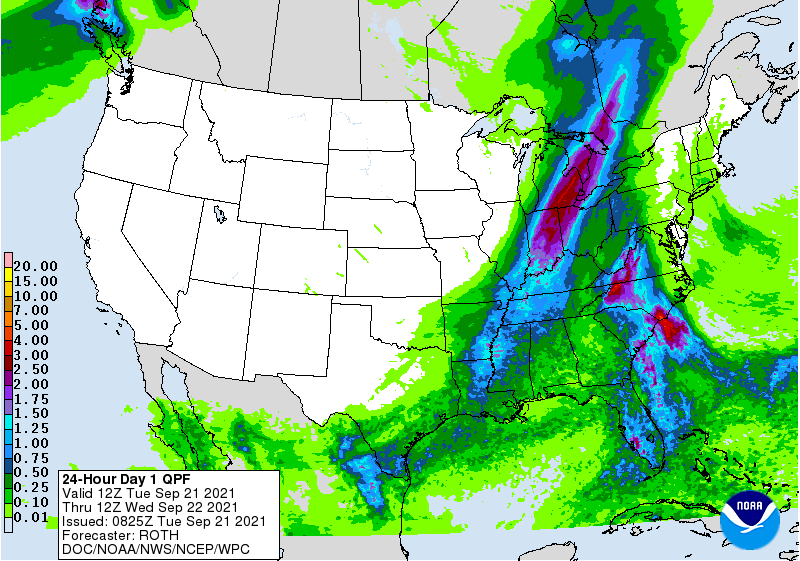
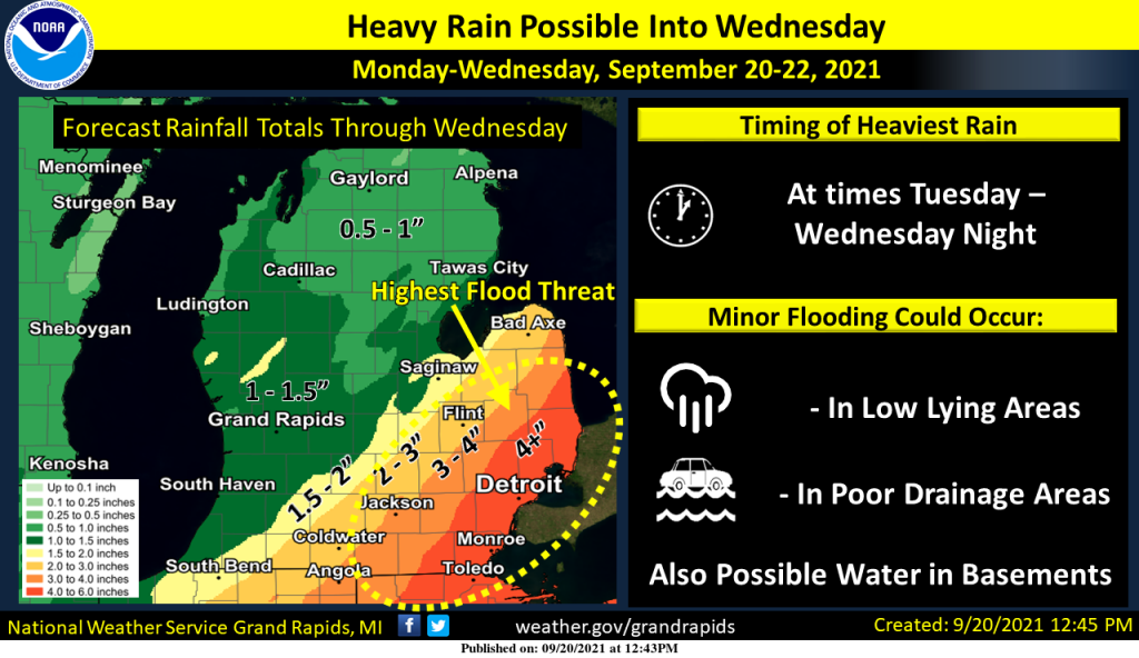
The National Weather Service in Grand Rapids has issued a

* Flood Watch for a portion of south central Michigan, including
  the following areas, Calhoun, Clinton, Eaton, Ingham, and
  Jackson.

* From 2 PM EDT this afternoon through Thursday morning

* Periods of moderate to heavy rain are expected from this
  afternoon through Thursday morning. Rainfall amounts in some
  areas may exceed 4 inches. Despite rather dry conditions of
  late the potential for this magnitude of rainfall over about 36
  hours may lead to areal flooding and flooding of smaller creeks
  and streams.

* The potential exists for small stream and creek flooding as
  well as flooding of low spots where water may cover some roads.
Forecast Discussion
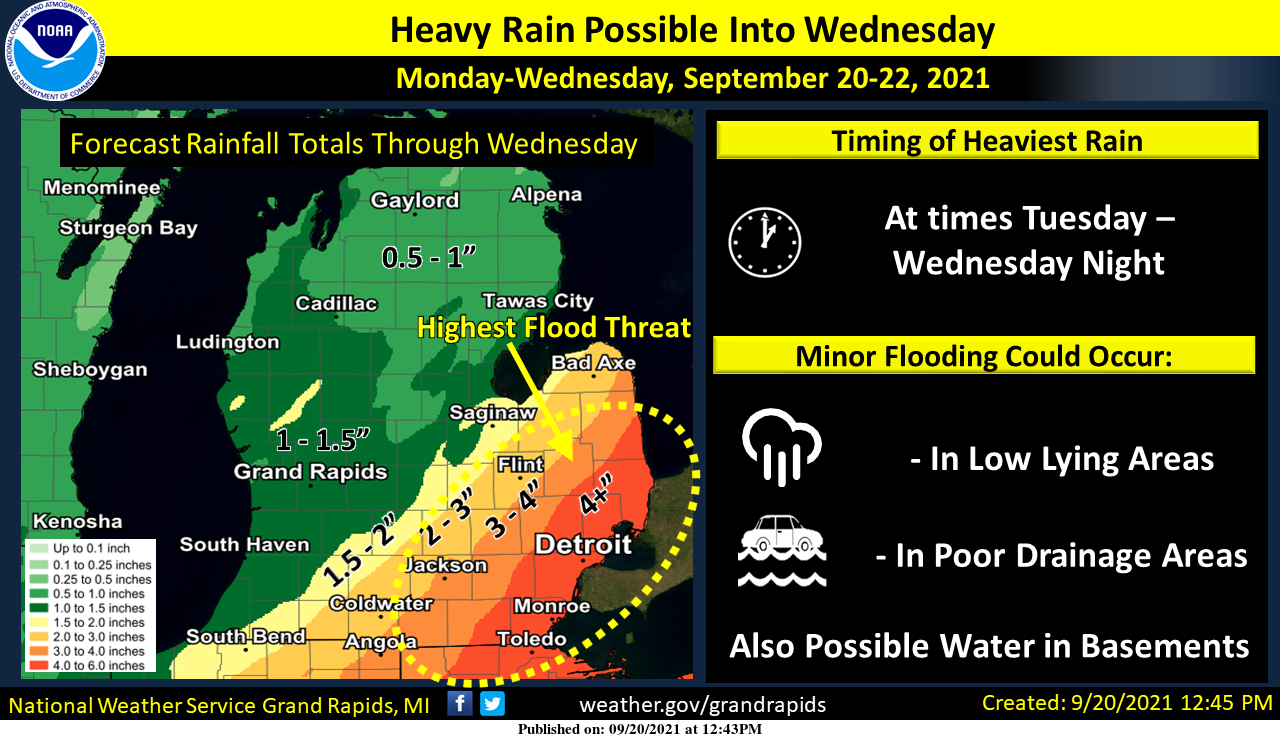
- Heavy rain potential over South Central Lower Michigan

We will be issuing a Flood Watch for a portion of South Central
Lower Michigan this morning, which will run from 200pm Today
through 800am on Thursday. The counties in our area included will
be Jackson, Ingham, Calhoun, Eaton and Clinton.

The potential exists for heavy rain beginning this afternoon
lasting into Wednesday night. Models are consistent in showing a
signal for at least 3 inches of rain over these counties. In fact,
many of the ECMWF ensemble members are showing at least 4 inches.
The HREF max qpf through Wednesday evening has 4-5 inch totals in
Jackson. The operational GFS has 5-6 inch totals into Ingham.
Bottom line there is more than enough signal for a Flood Watch
despite antecedent conditions being on the dry side.

The concern is that rain spreads into the area today along and
ahead of the front pressing in from the west. Rain will continue
along this boundary over the area tonight. Late tonight an upper
low forms off to our south. The low then deepens and tracks
through our area Wednesday and Wednesday night bringing additional
rain. Much of the time an 850mb front will be located over South
Central Lower Michigan with isentropic lift sweeping up the
pressure surfaces. There should be efficient rain processes
ongoing that will really add the totals up over time. Outside of
some embedded thunderstorms today into this evening, the bulk of
the rain will just be a steady moderate to heavy rain like we
would see from a wet fall system (which this one is).

Elsewhere across the area will we will see a band of showers and
a few storms working through the area today. Rain will occur at
times across the rest of the forecast area, but the heaviest and
most concentrated will be towards the Lansing and Jackson areas
and points to the east.

- Rain lingers into the later portions of the work week

The upper low that brings all the rain to portions of the state
through mid week will pivot to the north out of the area on
Thursday and Friday into Ontario. Thursday we will be plenty cold
enough aloft that as the winds turn northwest and off of Lake
Michigan, we will see lake effect rain showers. The rain showers
will likely taper off Thursday night as we warm a bit. Much of
Friday will be dry ahead of our next cold front.

- Showery fall like weather continues into the weekend

Rain showers are expected once again Friday night into Saturday as
a cold front works through the area. Saturday behind the front we
turn cold enough once again for lake effect rain showers with
delta t`s in the middle to upper teens C. Much of the next 7 days
will feature active weather and as you would expect this time of
year temperatures will be on a bit of a roller coaster.
My point forecast gave me 1/2 inch of rain today and we received a dusting! Another total miss form the NWS! Incredible!bring on the rain!
62* degrees out in my area break out the hoodiees FALL …INDY
Great! Keep it rocking!
https://youtu.be/Gs069dndIYk
Do you remember???? Lol
40’s for highs in the upper peninsula of Michigan wow …INDY
Indy there are lows forecasted in the 40’s and 30’s in the UP but I do not see any highs in the 40’s at this time.
Slim
With some rain to knock down some of the pollen and cooler temps…open windows will soon follow!!! Lol!!! Happy Last Day of Summer!!!
Has anyone looked at the weather for next week and beyond? Lots of 60’s and 70’s until almost Halloween. A warm October?
The current temperature of 69 is the overnight low here at my house. More likely than not this will be the warmest overnight low here until next summer. So far there has been 0.07″ of rain here yesterday and overnight. At this time with that temperature of 69 there is a light mist falling.
Slim