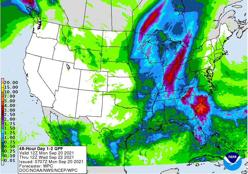
Yesterday we had a high temp of 86°! Though not uncommon this was a sign summer has not been willing to give up its grasp on us this September. Now it is abundantly clear we have seen the last of our warm and dry month come to an end with the remnants of tropical depression Nicholas heading our way and a cold front pulling in behind it on Tuesday. Below is the QPF depiction through Wednesday which hasn’t chanced much since yesterdays run.
Sunrise today is 7:28, sunset is 7:43 pm.
Forecast Discussion
- Periods of showers and storms Today through Tuesday

Showers will lift into the forecast area from the south this
morning. These showers are associated with the left over moisture
from the former tropical system Nicholas. So, there will be
efficient rain processes occurring leading to moderate to heavy
rain at times. We expect a diurnal boost to the activity which is
depicted in the 4hr max reflectivity prog in the HREF. After 300pm
or so we should see some embedded thunderstorms form which will
lead to a locally heavy rain threat. Most Unstable CAPE values
today will reach near 1,500 J/KG with PWATs approaching 2.00
inches. Expecting rain totals in spots to reach the 0.50 to 1.00
inch range. Not expecting severe weather given extensive cloud
cover and overall low instability.

The precipitation will taper some tonight as the main surge of
moisture heads off to the north. A cold front will approach from
the west however with likely an even better swath of
precipitation. The front will be moving into an air mass that will
still have PWAT values on the order of 1.9 inches so locally heavy
rain will remain a threat. Heaviest rain tonight will be over
northwest portions of the forecast area for places north and west
of Grand Rapids.

The front will continue marching to the east on Tuesday with a
swath of showers and embedded thunderstorms transitioning across
the area. Heaviest rain on Tuesday will be from Grand Rapids to
the south and east in a post frontal setup. Locally heavy rain
will remain a threat, with fairly widespread totals around an inch
across the southeast and eastern CWA. Lansing and Jackson stand
the best chance to see the heaviest rain where totals through
Tuesday evening could push towards or exceed 2 inches.

We still feel that we should be able to handle this level of
rainfall as the rivers are all quite low. That said if training
does occur and it will likely do that in the northwest CWA tonight
and over the eastern CWA on Tuesday, we could see some local,
short term drainage issues. If we become concerned with any areas
they would be handled by short term Flood Advisories. At this
point, not expecting that to take place.

Instability dwindles even further on Tuesday, so not expecting
severe weather with the cold frontal passage.

- Showery weather expected mid to late week

Will opt to follow the ECMWF in terms of the overall pattern in
the mid to late week time frame as the GFS seems to be playing
catch up to it with regard to a low retrograding into our area.
The low is overhead in the Wednesday and Thursday time frame which
will lead to additional showers. Some areas of the CWA will get a
good soaking out of this pattern by Thursday and Friday. Soil
moisture levels will certainly be on the rise by the end of the
week. When the flow turns off of Lake Michigan (and much of the
time it will be northerly) we will stand the chance at lake effect
rain showers. The lake is around +21C right now, so lake effect
rain begins with 850mb temps around +8C. We are cooler than +8C
much of the forecast period.

- Cool down still on track behind Tuesday`s cold front

The cool down remains on track with 850mb temperatures mainly in
the single digits C after Tuesday. Coldest air is on Wednesday and
again on Saturday. It will certainly feel like fall with highs in
the 60s much of the time. We do even have some 50s highs across
Central Lower and I see this expanding in area as we get head
towards Wednesday.
Off and on showers here. You can tell that these are from Nicholas. It “feels” tropical. The cloud formations are super cool too. They’re not like clouds we usually see in this area.
Still waiting for today’s rain. Not even a drop yet….
Highs in the 40’s and 50’s coming heloooo FALL…INDY
Where are the highs in the 40’s and 50’s? Lowest highs in the forecast are in the 60’s and the rest are 70’s. Looks like perfect weather coming up to me.
False
It’s been so nice to have 4+ months of continuous summer temps. What a long summer!
Lk Michigan water temps are still as warm as July levels.
Rather impressive Summer day yesterday. We went to the Holland beach and it was just packed. Looked more like a mid July day instead of late September. Even the water temp is still in the 70’s yet. Looks like we may finally get some September weather for the final week and a half. Been a looooong Summer again this year.