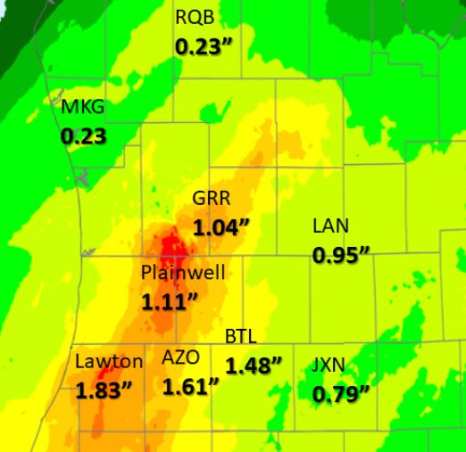
 We had heavy rain as expected overnight – 1.56″ in Otsego from my rain gauge this morning. We were right in the middle of a swatch where the heaviest rain fell.
The graphic to the left shows radar estimated totals at 4 am this morning.
The rain will slowly come to an end between 7 am and 10 am this morning. Already rainfall reports, as of 4 am show over an inch has fallen at Grand Rapids (GRR), Kalamazoo (AZO) and Battle Creek (BTL).
This takes a big bite out of our rain deficit for March, most areas having seen only around a tenth of an inch for the month.
Our weather pattern will continue to be more active over the next several days with temps bouncing from cool to warm with chances of light rain in between.
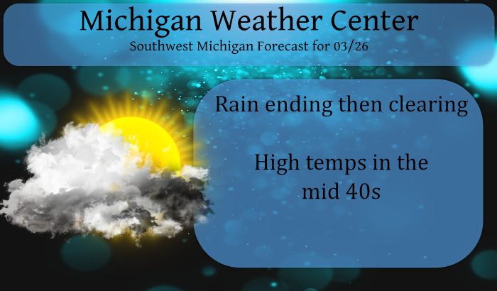
Forecast Discussion
- Storm moves out by mid morning quiet weather by afternoon-

Our storm largely did what we were thinking. Mostly it has been a
heavy rain event near and south of I-96. By 2 am Kalamazoo has had
nearly and inch of rain. The heavy rain should come to an end by
5 to 6 am as the system continues to track northeast into
Southwest Ontario by 8 am. Some wet snow or possibly a little
freezing rain is still possible near Route 10 but the model
sounding are largely to warm for any significant freezing
precipitation from this event. I am still thinking 1 to 1.5 inches
of rain near and south of I-96 from GRR east as a storm total
rainfall.

The thunderstorms are largely staying south and east of our CWA
and the associated mid level instability forecast go along with
that idea. So not to much to be concerned about with that this
morning. What ever does happen with that, it should be east of
Michigan by 8 am.

The wind gusts have largely been in the 20 to 30 mph range. The
strongest gusts so far have been in the 35 to 40 mph range in the
Battle Creek to Kalamazoo area. That is where the heaviest
rainfall is occuring. Wind gusts in the 30 to 40 mph range should
be expected between I-94 and I-96, mostly east of US-131 till
around 8 am this morning.

An upper low did close off at 500 mb and the center of that upper
low will be over the Detroit area at 8 am and moving quickly
northeast. The surface low will be directly under the upper low at
that point and should be well northeast of this area by noon. In
fact mid level ridging moves into this area by noon (500 to 300
mb). That will quickly clear the clouds out by early afternoon.
Winds will really subside by noon too. Gusts will be under 20 mph
by then.

The mid level ridging is the result of the next system heading
this way. As the upper trough deepens west of us tonight the upper
ridge over us will build due to Rossby wave interactions. That
will mean mostly clear skies and lows mostly in the 20s to near
30.

- Next system moves through this area Saturday evening -

As the 130 knot jet core over Alberta digs into the western side
of the next trough heading this way Saturday, the southern branch
jet core is forced sharply northward. At sunrise Saturday it will
be south of I-80 but by sunset that jet core will over central
Lake Michigan. We will be in the jet entrance region. That will
induce a wave on the front as it passes us early Sunday morning.

The result will be showers Saturday afternoon into early Sunday
morning. This will be a 1/4 inch sort of precipitation event.
While it will get cold enough to snow by mid morning Sunday by
then the precipitation will have ended so this will just be a rain
event. The cold air behind this front is significantly colder
than the air behind the system today. It is marginally cold
enough for lake effect snow showers by Sunday evening, however the
air is to dry by then so expect a cool day Sunday with clearing
by midday.

- Warming early next week then another system midweek and colder -

The next upstream Pacific system is a fairly large system and will
be slow to move across the CONUS next week. That will build a much
larger upper ridge over the eastern CONUS by Tuesday. That in
turn will warm us up considerably. There should be a lot of
sunshine then too.

Of course the upper flow is progressive so the upper trough moves
in to the area by Wednesday. This will bring much colder air into
the area by late in the week. We may struggle to have highs near
40 by Thursday. Our forecast currently only has very low chance
for showers Wednesday, likely this is a result of model timing
issues. There will be showers with that system as it comes through
mid week. Count on it! If fact, if we can get a wave to form on
the front we may just see accumulating snow by Thursday but that
is questionable at this point but still really possible.
Wow, major cold front coming through next week! The high temp on April 1st in the upper 30’s and the low may get down around 20 degrees! Incredible cold! Forget golf!
I won’t golf on Thursday, but I’ll golf tomorrow, then next Saturday and Sunday!! Fantastic golf weather for these past 4 weeks!! Who knew?!?!! Looking at 8 months of golfing coming up this year!!
https://weather.com/weather/tenday/l/b4ea0280869baa46799dc75eacef8904785ec43ad2f6fb098355fbc208a55e2c
Delusional!
Sunday, Wednesday and Thursday look like trash, but the rest of the forecast looks FANTASTIC!!! Plenty of golf weather!! I love long springs!!!
https://weather.com/weather/tenday/l/b4ea0280869baa46799dc75eacef8904785ec43ad2f6fb098355fbc208a55e2c
Looking good Andy ! It’s just March. We will have our up and downs on Temps. We ended up again with a below normal snowfall winter.
For sure! I am love this early spring so far!
Wow!! Hopefully no one is going to Florida next week for Spring Break!
Here is a fun fact. In 2007 the H/L for today was 75/65 and was the 2nd day of 3 days in a row with highs in the mid to upper 70’s Between March 21st and April 3rd 2007 there were 10 days of 60 or better and 4 of the days were 70 or better and all of the days were 50 or better. Then from April 5th to the 12th there were 7 days with highs in the 30’s two days the high was 30 and one day the high was 29 and in the 7 days 6.7″… Read more »
Just over a half inch of rain here. Leaving early this morning for work the grass sure looked incredibly green in the headlights.
I recorded 0.67″ of rain fall here. At this time there is light rain falling with a temperature of 36.
Slim