Our high yesterday was 42° and the low was 18° with mostly sunny skies. Today will feature another sunny day with temperatures reaching into the low 40s to help continue our snow melt.
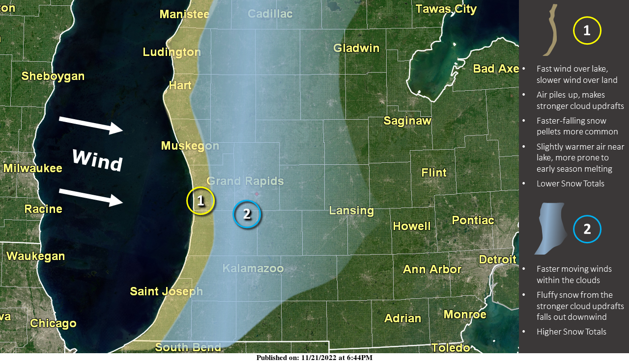
Super Snow Question: If this was Lake Effect, why did the lakeshore get less snow than Grand Rapids and Kalamazoo? With last week’s wind direction from the west, air piling up near the lakeshore made cloud updrafts stronger, but strong winds in the clouds pushed the quantity of snow inland. Longer answer: Near the lakeshore, where fast-moving wind over the lake bumps into the slower-moving wind over the land, this pile-up of air makes cloud updrafts stronger, but faster-falling snow pellets tend to be more common here, and these don’t accumulate very quickly. Additionally, since we are early in the snow season and the lake is still quite warm, the lakeshore can see more rain or melting snow whenever temperatures are marginally cold elsewhere. All this contributes to lower snow totals given a wind direction from the west. Farther inland, especially near US-131, due to fast-moving winds within the clouds, fluffier snow which accumulates more rapidly is pushed downwind as it falls out from where the stronger cloud updrafts occurred.

Wondering how this Thanksgiving will stack up to past years? Here are the extremes that have occurred on Thanksgiving in Grand Rapids, Lansing, and Muskegon.
Forecast Discussion
-- Areas of freezing fog this morning...Dry into Wed --

Latest IR satellite imagery and surface obs indicate extensive
stratocumulus over central/northern Lower MI as of 08z. Little
additional southward advance of these clouds is expected, and
short-range guidance suggests that southerly cloud-layer flow
will become established as the morning progresses in conjunction
with modest surface pressure falls occuring west of the region.

South of this cloudiness, clear skies and light surface winds over
much of the forecast area will foster areas of freezing fog this
morning as strong radiational surface cooling continues. Some
icy/slick spots will be possible on roads this morning,
particularly on bridges/overpasses. Patchy freezing fog will
again be possible tonight/Wed morning in similarly favorable
conditions.

Otherwise, dry conditions will prevail into Wed. A shortwave
trough/vort max--currently evident in WV imagery near ND/Manitoba--
will glance the area this afternoon/evening and provide modest
forcing for ascent, but dry profiles will keep precip well north of
the forecast area.

-- Thanksgiving Day through Sun --

Global ensemble guidance continues to indicate that an upper ridge
over the Pacific NW / northern Rockies will amplify on Wed/Thu,
ultimately undergoing anticyclonic Rossby-wave breaking into Fri.
Southward of this folding-over ridge axis, an upper trough will
dig across the Rockies on Wed, then deepen into a closed/cutoff
low near NM/TX on Thu/Fri. Ensemble guidance continues to exhibit
appreciable uncertainty regarding the subsequent evolution of this
upper low into the weekend, with (1) large values of normalized
spread in the 500-mb height field, and (2) poor run-to-run
consistency in the ensemble-mean placement of this feature in
both EPS and GEFS runs. This uncertainty notwithstanding, the most
recent EPS/GEFS means have trended notably slower with the
northeastward advance of this feature into Sun.

Altogether, there appears to be two timeframes during which precip
is possible over the holiday weekend (Thu-Sun). The first is Thu
evening/night, when a shortwave trough and associated vort max will
progress through the region. Most EPS members produce precip over
the region during this period, although amounts are fairly light
(0.1 inch or less) and have trended lower in recent runs. Thermal
profiles during this period suggest that an all-rain event is
likely. This update will feature likely PoPs along the I-94
corridor, with chance PoPs elsewhere.

Another precip episode is possible on Sat night into Sun in
conjunction with the aforementioned mid/upper-level cutoff low
lifting northeastward toward the region. Forecast confidence
regarding this period is still limited, given the considerations
noted earlier, and precip amounts will likely be sensitive to the
placement of the midlevel low and its associated surface features.
However, EPS and GEFS means have shown a trend toward warmer
surface temps during this period, and EPS/GEFS probabilities of
subfreezing temps on Sat night have lowered, suggesting a limited
risk of freezing precip. An all-rain scenario or perhaps a
rain/snow mix in some areas appear most favored during this
timeframe. Chance PoPs will be maintained with this update--
highest south.
Just ventured out to get the mail. Gorgeous day. 45 with a warm sun and a cloud-free sky. High temps should remain in the 40s to near 50 through the weekend, which is nice for travelers.
It feels pretty warm out with no wind and full sunshine. I’d imagine there will be more melting today… although the sidewalks are still very slippery this morning
Thanks for the lake effect info MV. I’ve had a lot of people ask me the past couple days why we were in storm warnings for several days and only ended up with a few inches of snow, now I can show them this. After yesterdays melt our yard is down to areas of bare ground to an inch or two in spots. Should be all gone by tomorrow.
Nice information on Lake Effect. One note the warmest Thanksgiving day high at Muskegon of 63 was set in 2012 and 1908 not 2008.
Slim
Yesterday, with 91% of possible sunshine and a high of 40 and a low of 22 seen a good amount of snow melt. The day officially started with 7” on the ground at Grand Rapids. There was no precipitation and no snow fall. Here in MBY the overnight low was 16 it is now up to 21 here. For today the average H/L is 44/31 the record high of 66 was recorded in 1913 and the record low of 13 was set in 1929. The record snow fall for today is 7.0” in 1985 there was 6.8” in 1945. The… Read more »