
Yesterday we broke out of our lake effect and the sun came out to make a welcome appearance. Our high was 30° and the low was 18.5°.
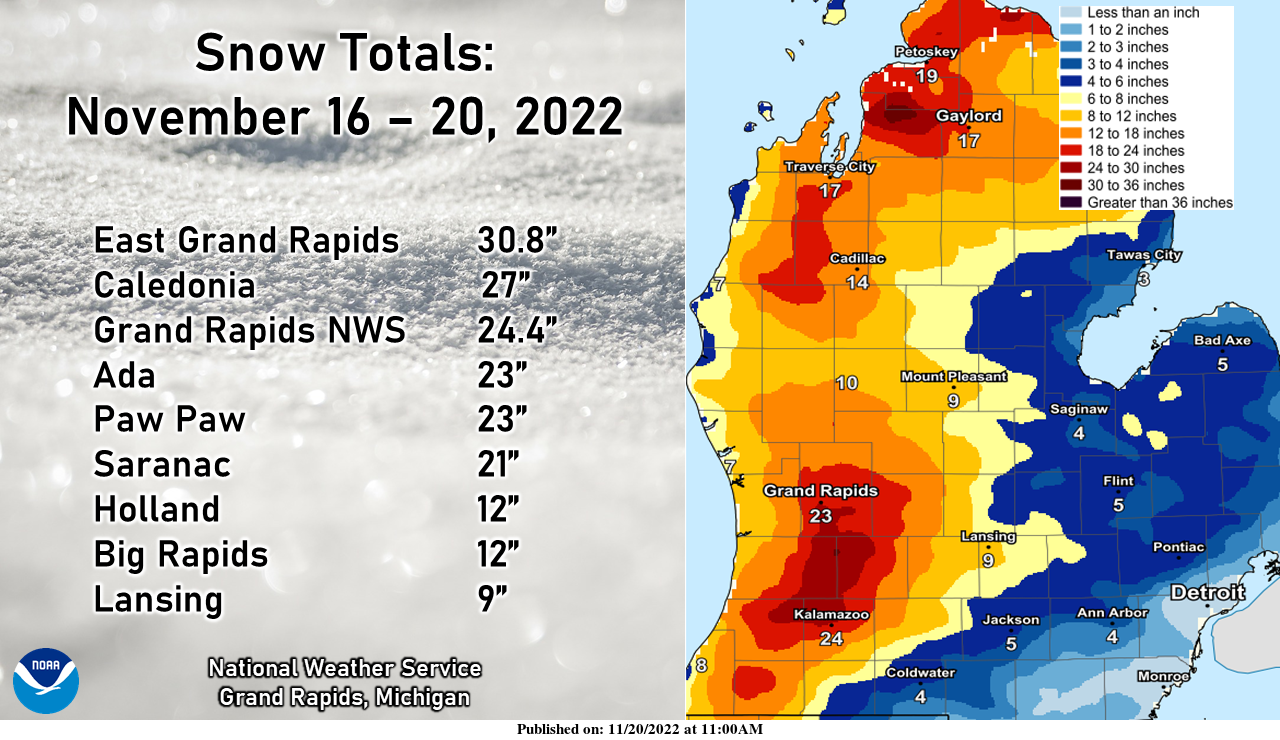
Pretty impressive snowfall was noted across the Lower Peninsula, especially up and down the US-131 corridor.
We will start the day with sunshine before the wind switches back to the west increasing our cloud cover. Winds will be gusting 30 to 35 mph.
Forecast Discussion
- Windy today -

Fair wx is fcst today with a mix of sun and clouds and seasonably
cold temperatures. However it will be rather windy with a strong
pressure gradient in place this morning and as deeper mixing
develops. Wind gusts to 30 to 35 mph range are expected later
this morning into the aftn. Some higher gusts to near 40 mph are
possible mainly over our se fcst area late this morning/early aftn
as suggested by the latest runs of the HRRR and 00Z HREF.

Tranquil wx is fcst tonight through midweek as the upper pattern
becomes rather zonal and temperatures undergo a slow moderating
trend. A consensus blend of our latest numerical guidance max/mins
is likely a bit too mild with max temps through midweek given the
very expansive snow cover in place across much of our area.

- Wx becomes a bit unsettled late this week -

Trends in latest medium range guidance suggest that a cold front
will approach from the west on Thursday and bring a chc of rain
showers. Fropa will most likely occur Thursday night and a
slightly colder airmass will move in and result in potential for
light mixed pcpn Thur night/Friday. At this time very little if
any impacts from the light mixed pcpn are expected with sfc temps
staying above the freezing mark.

Near to slightly above normal temps are expected next weekend.
Tranquil wx is probable but larger medium range guidance
discrepancies that far out in time result in lower forecast
confidence for next weekend and beyond.
Nice day today. 42 and sunny. We lost about 1/2 of our snow. Yard is 50/50 green and white (pun intended).
Amazing that this was the first time ever Grand Rapids Michigan had 7 inches of snow or more in a 3 day span and its only November… I find that hard to believe… INDY
Great start to winter, record breaking events and a record breaking month! Just a sign of things to come! What a storm and what a winter! Wow, just wow!
I have to say that after what seemed like an endless stretch of boring weather, this event was very exciting. Will we incur more excitement this winter, or will we revert to the boring? We shall see…
The official H/L yesterday at Grand Rapids was 27/18. There was 0.7” of snow fall. At 7 AM yesterday there was 10” of snow on the ground at GRR. Here in MBY the temperature fell to 18 before midnight but rose to 21 after midnight and that was the overnight low here. At the current time it is 23 and partly cloudy. For today the average H/L is 45/31 the record high of 70 was set in 1913 and the record low of 10 was set in 2014 the record snow fall amount of 4.0” was set way back in… Read more »
The snow event of November 2022 is now over and at Grand Rapids it was sure a record setting event. With 6 days in a row of snow fall. The total for the 6 days was 27.6” That in its self is good for the 2nd snowiest November at Grand Rapids. The total snow fall of 28.0” is the new 2nd most for any November. Note on the event snow fall total I added the 3.2″ that fell on the 15th while not part of the later event it still is a 6 day total and not a 5 day… Read more »