I have been having second thoughts about putting the plow on my tractor and removing the mower deck this fall, seems we have been stuck in spring rather than winter.
Below are some noteworthy events for this year’s weather. Detroits summary is quite extensive so I will show this in two parts.
From the Grand Rapids Weather Office
A major ice storm impacted much of southern Lower Michigan while areas of moderate to heavy snow impacted central Lower Michigan on February 22, 2023. Hundreds of thousands of customers lost power across southern portions of the state as freezing rain accumulated on trees and power lines, bringing branches, trees, and power lines down in many areas. In between the areas of freezing rain to the south and snow to the north, sleet (ice pellet) accumulation reached a couple of inches deep.
For freezing rain to occur, snowflakes that fall from the sky need to completely melt and not refreeze into ice pellets before reaching the ground. That was the case for most areas south of the I-96 corridor during this event. Along and slightly north of the I-96 corridor, ice pellets persisted for most of this event leading to 1″-2″ of dense ice pellet accumulation. The environment stayed just cold enough above the surface to completely refreeze the melted snowflakes into sleet. Further north, the atmosphere was cold enough to keep precipitation all snow, where generally 2″-8″ fell.
Wind gusts reached the 25-35 mph range for many locations during the height of the event. This added an additional challenge to areas that received heavy icing on trees and power lines.
A winter storm brought heavy, wet snow to southern Lower Michigan from the afternoon of March 3 into early March 4, 2023. This storm produced a swath of 6″-10″ from Kalamazoo/Battle Creek east toward Lansing and Jackson, then extending into the Thumb Region. The weight of the snow on trees and power lines led to around 350,000 power outages across southeast sections of the state.
On August 24, 2023, severe thunderstorms formed over western Lower Michigan during the evening hours in the midst of an extremely unstable environment that also featured dew point readings (a measure of atmospheric moisture) around 80F, some of the highest we have seen over the last 60 years. These thunderstorms spawned two tornadoes in western Lower Michigan. The first tornado touched down in west central Kent County from Alpine Township to Plainfield Township, rated an EF-1 on a scale of 0 to 5 (with 5 being the most intense). The second tornado touched down in eastern Ingham County from Williamston to Webberville, before continuing on into Livingston County, and was rated an EF-2 in Ingham County before weakening to an EF-1 in Livingston County. In addition to the tornadoes, the thunderstorms produced numerous areas of 60 to 70 mph wind gusts and very high amounts of lightning. The combination of the tornadoes, strong wind gusts, and continuous lightning wiped out power to around 460,000 customers statewide at the height of the event.
From the Detroit Weather Office
January 25th, 2023 Snowstorm
A potent surface low-pressure system organized over northern Mexico Monday night as it tracked into southern Texas Tuesday morning. Supporting upper low pressure phased with an energetic southern stream jet which enabled the system to lift rapidly northeastward while strengthening. Colder air on the northwestern flank of the surface low ensured a focused swath of snowfall from New Mexico, through the Ohio Valley, and into The Northeast by Thursday with persistent Gulf moisture feed. An initial round of snow driven by isentropic ascent began early Wednesday morning which spread from south to north across Southeast Michigan as the low crossed into the Mid-Mississippi Valley. This produced a coating of snow to around two inches by sunrise. The system’s meager dry slot then attempted to work in which led to a few breaks with mid-morning snowfall. Snow then resumed in full force late Wednesday morning ahead of the heaviest banded features.
Heavy snowfall occurred midday Wednesday with strong frontogenetic circulations, elevated instability through the DGZ, and deformation forcing which produced large fluffy snowflakes and snowfall rates near one inch per hour at times. Thunder snow was observed just to the east over southern Lake St. Clair during the heaviest snowfall as the surface low approached Lake Erie Wednesday afternoon. A
A low-pressure system developed along a frontal boundary draped across the Midwest and moved northeastward through southeast Michigan on the morning of January 29th. As this system approached during the afternoon and evening of January 28th, a lead wing of isentropic ascent and warm air advection brought the onset of accumulating snowfall across central and northern portions of southeast Michigan. Throughout the night intensity of snowfall increased for areas north of I-69. A corridor of stronger frontal forcing along with thermal profiles conducive for periods of heavy snow developed moved into the Tri-Cities during the early morning hours bringing snowfall rates up to an inch per hour for several hours and reaching a storm total snowfall of 7-8 inches in parts of the Tri-Cities.
A sharp gradient in snowfall totals developed with a significant drop-off for areas south of I-69 as dry air cut into the totals along and south of the rain/snow line. There were points mainly along and south of the I-94 corridor that experienced a period of light wintry mix and light freezing rain during the morning hours of January 29th as surface air temperatures held at or below freezing. Snowfall totals for areas south of I-69 were around an inch or less before precipitation ended during the mid-morning hours.
Activity diminished quickly Wednesday evening as stabilization settled in behind the departing system which brought an abrupt end to the snow for most locations by 7 PM. Lake effect snow showers impacted portions of The Thumb and southern Huron shoreline areas into the overnight hours. Overall snow accumulations ranged from four to nine inches across the Winter Storm Warning area while amounts between two and four inches were realized elsewhere.
January 28-29 2023 Winter Storm
A low-pressure system developed along a frontal boundary draped across the Midwest and moved northeastward through southeast Michigan on the morning of January 29th. As this system approached during the afternoon and evening of January 28th, a lead wing of isentropic ascent and warm air advection brought the onset of accumulating snowfall across central and northern portions of southeast Michigan. Throughout the night intensity of snowfall increased for areas north of I-69. A corridor of stronger frontal forcing along with thermal profiles conducive for periods of heavy snow developed moved into the Tri-Cities during the early morning hours bringing snowfall rates up to an inch per hour for several hours and reaching a storm total snowfall of 7-8 inches in parts of the Tri-Cities.
A sharp gradient in snowfall totals developed with a significant drop-off for areas south of I-69 as dry air cut into the totals along and south of the rain/snow line. There were points mainly along and south of the I-94 corridor that experienced a period of light wintry mix and light freezing rain during the morning hours of January 29th as surface air temperatures held at or below freezing. Snowfall totals for areas south of I-69 were around an inch or less before precipitation ended during the mid-morning hours.
February 22nd, 2023 Winter Storm
A major winter storm impacted Southeast Michigan during the daytime and evening hours of February 22, 2023. Warm/moist air originating in the Gulf of Mexico surged north toward a surface warm front, increasing coverage and intensity of precipitation over lower Michigan by mid-morning. This warmer air aloft interacted with a resident cold airmass near the surface, creating conditions favorable for snow to the north and a wintry mix for much of the metro Detroit region. The higher snow accumulations occurred across areas north of I-69, with Midland receiving a report of 8.9 inches for the storm total. Communities south of I-69 saw a wintry mix of snow, sleet, and freezing rain which resulted in widespread ice accumulations of a quarter to half inch. The impacts from icing were widespread, with DTE reporting nearly 3,000 downed wires and close to 500,000 customers without power. Similarly, numerous reports of downed tree limbs were reported making some roads impassable. For many metro Detroit communities, an ice storm with this widespread footprint has not been observed since April 2003.
February 27th, 2023 Winter Storm
A wintry mix of precipitation associated with a low pressure system impacted Southeast Michigan through most of the day on February 27th while lighter snow continued through the early overnight hours further north. A pronounced transition zone developed between areas that received mostly rain (south of I-96) and areas that received mostly snow (north of M-46). A Winter Weather Advisory was in effect between the late morning hours and early evening hours along/north of M-59. The first wave of precipitation moved in from the southwest with most locations initially receiving a mix of sleet and freezing rain as surface temperatures hovered near freezing and modest east wind facilitated the influx of drier air. Precipitation rates increased midday with periods of heavy rain and sleet across the south while areas to the north experienced a quick burst of snow mid-afternoon. At one point, the northern tier of counties (Midland, Bay, and Huron) experienced snowfall rates in excess of an inch per hour leading to the snowfall totals of 4-8 inches. Additional light snow showers north of I-69 concluded with the departure of the wave after midnight. Icing from a freezing rain/sleet mix was most prevalent between M-59 and I-69 which led to the re-icing of trees and utility lines which were then subjected to wind gusts of up to 35 mph. This led to additional delays in power restoration, just five days after an even more impactful ice storm.
March 3rd, 2023 Winter Storm
A significant winter storm impacted southeast Michigan on the afternoon and evening of Friday, March 3, 2023. A compact but very strong low-pressure system tracked up the Ohio Valley, bringing strong lift and abundant moisture to the region. Despite air temperatures hovering near or slightly above freezing in many areas, the heavy snowfall rates allowed for rapid accumulations during rush hour and into the evening. Snowfall rates became so intense (2-3 inches per hour in some locations) that numerous bouts of thundersnow were observed in the evening. The heavy, wet snow exhibited snow-to-liquid ratios below 10:1 and piled up quickly on trees and power lines that were already stressed from recent winter storms on February 22nd and February 27th. This, combined with gusty winds, resulted in over 200,000 customers losing power across the area. The strong winds also resulted in lakeshore flooding along the Lake Erie shoreline.
Widespread snow totals of 8 to 11 inches occurred along a corridor from Jackson to Howell and Ann Arbor, the northern Metro Detroit suburbs, Lapeer, and parts of St. Clair and Sanilac Counties. A sharp snowfall gradient occurred to the north over the Tri-Cities and Thumb which saw totals generally ranging from 1 to 5 inches. To the south, milder air allowed for some rain to mix in at times across Monroe, southern Wayne, and parts of Lenawee Counties which reduced snowfall totals in those locations. Daily snowfall records for March 3rd were broken/tied at all three climate sites: Detroit – 6.2″ (previous: 6.0″ from 1875); Flint – 4.9″ (previous 4.9″ from 1954); Saginaw – 2.5″ (previous: 2.3″ from 2015).
March 10th, 2023 Winter Weather Advisory
A winter storm impacted southeast Michigan mainly during the morning and mid-day hours of March 10th, 2023. This system produced widespread snow accumulations of 2 to 5 inches with locally higher amounts in excess of 5 inches concentrated south of I-94 and near the Lake Huron shoreline. Just to our west in Grand Rapids, localized accumulations up to a foot were reported likely due to a robust snowband on the leading edge of the precipitation shield. Snow-to-liquid ratios favored typical snowflake characteristics for early March, resulting in a drier/fluffier snow in comparison to the March 3rd, 2023 winter storm. A notable feature of this system was the substantial melting that occurred throughout the day, owing to the March sun angle and daytime temperatures rising into the mid-30s.
I will continue tomorrow with the spring/summer Detroit summaries…
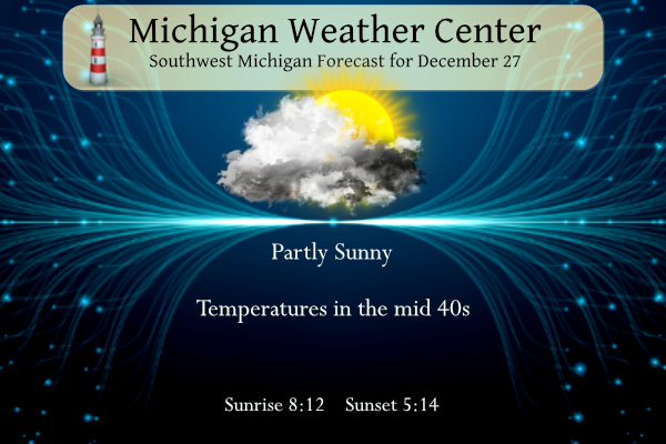
Forecast
Forecast Discussion
-- Brief opportunity for sun today in West Michigan --

Satellite shows a narrowing dry slot in the mid-upper levels over
western IN and western MI which is wrapping into the occluded
Missouri low. At the surface, there is an axis of diverging air
centered over Lake Michigan, situated between the Missouri low and a
frontal triple point in the vicinity of Lakes Huron/Erie. Low-level
clouds have been evaporating over northern Indiana to southwest
Michigan. This is setting up to give west Michigan some sunshine
today (it`s hard to be definite given the time of year with air that
is still not too far from saturation). Meanwhile, closer to US-127
and north of I-96, clouds are expected to hang on and
drizzle/showers should develop during the afternoon as the surface
trough deepens over Lakes Huron/Erie.

-- Rain showers tonight into Thursday --

Surface and mid-level flow becomes more northeasterly over our area
on Thursday as secondary cyclogenesis occurs over Lake Erie to far
southern Michigan. The likelihood of occasional rain showers is
increasing, t7hough QPF amounts may not be all that heavy. We
will still be on the warm side of the system (colder air to our
south over the Ohio river valley), and even in the highlands of
central Michigan temperatures should be just warm enough to avoid
freezing drizzle. Thursday`s low temperatures around 40 from
Kalamazoo to Lansing would even be near record warm for the date.

No major storms or cold air outbreaks are expected in the long term
period. Scattered rain showers associated with the upper low south
of MI linger Thursday night and Friday before a brief period of
shortwave ridging brings the likelihood of dry weather for Saturday.

An upper trough drops in from the northwest for New Years Eve but
considerable uncertainty/spread remains regarding the evolution and
speed of that trough as well as how cold H8 temps will get (and how
soon). Other complicating factor is that the low level wind
direction is not clear due to uncertainly in the position/timing of
the sfc low/trough.  Therefore as H8 temps eventually become cold
enough to support lake effect, it is difficult to say which (if any)
locations have a shot at seeing some light accumulations.

In any event, this looks to be a minimal/low impact system with only
light QPF as we ring in the new year. However would not rule out
some slick spots overnight if/where snow showers are more persistent
as sfc temps dip into the 20s.

Current expectation is for another (brief) push of mild air arriving
from the west next Tuesday behind the departing upper trough, then a
cold front dropping down from the north midweek.
I couldn't help but post this as it is a rare event:


Hey Rocky and INDY, wouldn’t this be epic? One could say hello blizzard! But obviously way too far out given its out in fantasy land but Looks epic on the model though with a 963mb low.
Definitely looks like the Blizzard of 2011 this would be epic I’m thinking January is going to be snow stormy around west Michigan DDDD!! LETS GO!! INDY
That would be amazing! Too bad it is so far out! Here is the corresponding snowfall map!
https://www.pivotalweather.com/model.php?p=snku_acc-imp&rh=2023122718&fh=384
Other than the incredible fact that this month is anywhere from 7.5 to 9.0 degrees above average, the thing that stands out to me is how green my lawn still is at the end of December. Usually it’s dried out and brown by now, but not this year.
The warm weather nuts are restless today! WOW!
I’m thinking some Winter storm warnings coming in January stay tuned Mv’s best!!! LETS GO!! INDY!!
The winter nuts are really getting restless today. Woah! I guess that’s what happens with almost TWO FEET below average snowfall.
Take it to the bank! The only question is how
many?
Last years Ice Storm was my low point for 2023…did not enjoy it. Also, the funnels that “floated” over the Forest Hills/Cascade area were too close for comfort. We were 100 yards from serious damage. Enjoy this slow Winter start…we all know what is in store for us. Sixty to seventy five inches…no problem.
Yes, last years weather was crazy with tons of snow, ice, wind storms along with tornados, etc! It was wild and more to come starting next month! Get ready for winter!
The warm weather nuts are out of control today with false information! Some things never change!
There is no denying it had been terribly warm lately. I harvested some lettuce in the garden today! Haha. I was surprised to see it still going. I am not too hopeful for a pattern change, but I sure hope one is coming. The bugs and fishing next summer are going to be terrible without some actual prolonged cold weather.
Yes it has been a warm December but the false statements about last winter are ridiculous!
Like I said, last winter was wild with above normal snowfall, despite the fake news spewed by the warm weather nuts!
https://www.fox17online.com/weather/weather-articles/saturdays-snowfall-puts-22-23-winter-season-in-third-place-for-highest-snow
Only because of the snow that fell in 2022 and then melted right away – not 2023. You’re a year behind.
For Grand Rapids… Wildfire smoke. Biggest thunderstorm event in years. 3rd snowiest winter last year. Least snowy start to winter this year.
Technically the Christmas blizzard was 2022… but that was one of the biggest blizzards in recent history. I’m enjoying the slow winter this year, it’s great for running and driving!
Get ready GR! While some have said cancel winter and we will see less than 40 inches of snow, they are 100% incorrect! Get ready to rock!
We are now a whopping +8.3 degrees above average for December. The past two days have been more than +22 degrees above average. Blowtorch!
Artic Outbreak January 7th mark it down!! Feets of lake effect not out of the question for west Michigan!! LETS GO!!!! INDY
Sounds AWESOME!
Indy is correct. All signs point towards a colder snowier January and February! Let the good times rock n roll!
Bill is on the same page. Obviously with the warmer lake water that could set the stage for significant lake effect if everything comes together along with any Arctic air outbreaks.
“So, I think this El Nino is going to start to weaken and the warmest water relative to average will push a touch farther to the west.
This will weaken the effects of El Nino and give us a better chance of returning to a more typical winter weather pattern.”
Of course El Nino will weaken into 2024. That’s what it does.
With that said, most of lake effect generally comes in November and December when water temps are much warmer than freezing air. Water temps have plummeted down to the 30’s and 40’s now.
Plenty warm for lake effect snow. Bring it!
As usual Kyle, you are 100% correct and the warm weather fanatics are pushing out false and skewed information! Great job!
The first half of January looks “mild”… but perhaps the second half and February will be cold. Also don’t forget March and April are typically more “wintery”, and will probably have more snow than this past November and December
I wouldn’t call April wintery. Last April we had 21 days 50-83 degrees.
Then we had snow showers to kick of May LOL
May was perfect. Mainly 60’s, 70’s, 80’s, and a 90!
Keep the facts coming and just ignore the incessant warm weather fantasy talk! It has been happening for years.
It has been a snowy first half or 2023 with multiple snowstorms! Wow!
False. Most months in 2023 have seen well below average snow (January, February, April, October, November, and December). Pretty quiet.
You are 100% wrong as usual! Some things never change!
Please tell me what facts above are wrong LOL
It’s been a quiet and warm 2023 for the most part! Big lack of thunderstorms and now a complete lack of snowfall.
Our 4th warm year in a row.
What? NWS GR says more mild temps upcoming? I love it!
Today is yet another above normal temp day! Let’s keep this rolling right into Spring baby! Bring it!
We are about 3 weeks away from the mid point of winter already. Spring will be here soon!
You know it Mookie! Been a fantastic winter so far!
January looks fantastic for Winter fun!! Hopefully with the late start we will get cold and snow through May!!! DDDD DDDD LET ‘S GO!!! INDY
No doubt and that is almost a lock! Snow Rocks!
Breaking News…. Get your snowplows and snow blowers ready! No, winter is not cancelled and yes we will see multiple 4 plus inch snow events! Mark it down and get ready! Incredible!
Nothing about 2023 was uneventful in the GR NWS coverage area despite what some people may say! It was a historic year for some of us.
Thanks for the facts! Multiple huge snow
events and warming! It was a wild high snowfall winter!
“Warnings”
There was I believe 3 separate occasions of thundersnow! How often does that happen? Once is a treat enough let alone several.
At this time we will have to see just how much if any snowfall we get on Sunday as at this time Grand Rapids with just 1.3” is on track for the 2nd least amount of snowfall for any December. Grand Rapids with a seasonal snowfall of just 3.2”is also on track for the lowest total snowfall to start a winter season. One has to wonder just how much snowfall Grand Rapids will get this winter season.
Slim
For today the average H/L is 33/22 the record high of 60 was set in 2008 and the record low of-12 was set in 2017. The wettest was in 2008 with 1.51” the most snowfall of 9.0” was in 2001 the most snow on the ground was 22” in 1951. Last year the H/L was 26/16 and there was 13” of snow on the ground.
Slim
NFC North Champions! Ends a 30 year drought of horrendous football! They are having a good season, but have a very tough game this Saturday. It will be an interesting night of football on Saturday! On the bright side at least they are guaranteed at least one home playoff game!
It’s about time for the Lions.
Slim
+1
Rather short list of noteworthy weather from GR compared to Detroit, a mostly uneventful year. The past two days have been rather uncommon though with back to back days 20 or more degrees above average.
The biggest weather story this December continues to be the lack of snowfall and the very warm temperatures. At Grand Rapids the H/L yesterday of 52/43 the high was the 3rd warmest for any December 26th and the low of 43 was the 2nd warmest low. At Lansing the high there of 54 was the 3rd warmest and their low of 46 was the warmest. At Muskegon the high there 52 was the 2nd warmest and the low of 43 was the warmest
Slim
An uneventful year in the GR NWS coverage area. That’s a joke right? You do realize they are talking about the entire coverage area?
Where did I say uneventful? I said it was a rather short list for GR compared to the lengthy list for Detroit that MV needs 2 days to post.
“Mostly uneventful year”
It’s right in your post
There were 4 events posted for GR, unknown amount for Detroit. 4 events over 365 days is not many to report.
It’s because they are leaving out notable info. They didn’t go near into depth was Detroit did. The tennis ball size hailstorm of April 4 damaged roof and siding on tons of homes from Hastings up through the town of woodland. Damage is still visible today if you drive through there. How often do we get tennis ball size hail in April?
How about the historic early season snowfall on Halloween that canceled trick or treating in Muskegon to another date?
NWS didn’t compile what they could have. Because they are omitting info doesn’t make it an “uneventful” year.
I’m just going by what they reported, and that wasn’t much. As for other possible events, I don’t have any data in front of me to look them up.
You’re right, Barry. It was a quiet year for the most part. No snow, no thunderstorms. And warm.
Rock on Kyle – of course you are 100% correct! Keep the facts rocking! It was wild year of weather, that is for sure!