We have only had two days this month when it rained, the 12th and 13th when we received, .23 of an inch and from May 1st we have had 1.58 inches in Otsego so we are around five inches below normal for the past two months. The CPC continues to give us near to slightly above chances of precipitation for the rest of the month into early July. Even so, even if we get normal rainfall over the rest of the summer it won’t be a drought buster.

Fair weather will continue today through Saturday. There is a chance of rain and perhaps a few thunderstorms Sunday through early Tuesday. Saturday will be hot with temperatures rising to nearly 90° once again and we will see humidity levels increase through the weekend.
U.S.A and Global Events for June 23rd:
1944: The deadliest and strongest tornado in the state of West Virginia occurred on this day. The Shinnston Tornado that ravaged a path of destruction from Shinnston to Cheat Mountain, then on to Maryland and ending in Pennsylvania in the Allegheny Mountains, is the only twister to produce F4 damage in West Virginia. This tornado killed 103 people.
2010: An F2 tornado destroyed approximately 50 homes and caused damages estimated to be $15 million in Midland, Ontario. 12 people were reported to be injured. Ontario provided immediate provincial assistance of up to $1 million to aid in cleanup and repairs.
Grand Rapids Forecast
6 23 grrForecast Discussion
- Potential for showers today mainly eastern zones

Moisture advects in from the southeast today with PWAT values
shown to climb up around 1.5 inches near and east of a Grand
Rapids to Kalamazoo line.  Radar shows and area of rain in
central OH northward through central portions of Lake Erie. This
area of precipitation has been pivoting westward. Models show this
area of precipitation trying to track into our eastern zones this
afternoon. However they generally show it falling apart as it
does. The latest ECMWF however suggests a wet afternoon for places
as far west as Battle Creek, which is somewhat of an outlier.
Looking at the DGZ, it never really moistens up that far west,
even for the ECMWF. However for places further east like Lansing
and Jackson, there is a period of moistening of the DGZ this
afternoon which may support higher POPs there. As a result, we did
feature relatively high POPs mainly for the eastern zones given
they will see the best chance for a period of moistening around
the DGZ this afternoon. Further west towards Grand Rapids and
Kalamazoo, it is less certain that any precipitation will occur
there today. Therefore we will feature only slight chances for
showers for those locations.


- Lower temperatures today, heat returns Saturday

The increasing moisture today will support more in the way of
cloud cover. This cloud cover will act to hold back temperatures
compared to Thursday. In addition, the temperature at 850 mb will
be slightly lower which should act to keep max temperatures lower
today. Warmest readings will be over the Northwest quarter of the
CWA where the cloud cover will be the thinnest. Looking at
Saturday, the wind will be shifting as the low start to pull away
from the area. The temperature at 850 mb moderates again and PWAT
values drop off. Thus, we will see more sun on Saturday and mixing
heights will increase. Mid 80s to near 90 degrees are looking
likely. A lake breeze will likely develop and move inland during
the afternoon.


.LONG TERM...(Saturday night through Thursday)
Issued at 307 AM EDT Fri Jun 23 2023

Our primary long term fcst challenge is to evaluate convective and
svr wx potential Sunday. Forcing from a cold front and mid level
shortwave/pva will combine to bring scattered showers and storms.
Sufficient omegas and moisture will be present for convective
development and instability looks sufficient as well with potential
for sb/ml cape values to reach around 1000 j/kg.

Potential for svr wx seems largely contingent on how much
instability develops Sunday afternoon and evening. At this time
areas south to southeast of our fcst area seem favored for sb/ml
cape values in excess of 1000 j/kg. Deep layer shear may briefly
become marginally favorable for organized convection but this is
also somewhat in question at this time and overall kinematic
profiles do not look too favorable.

The bottom line is we cannot rule out potential for a few strong to
marginally severe storms Sunday. However the greater svr wx threat
should stay south to southeast of our area where stronger
instability is expected.

Precipitation chances remain in the forecast Sunday night through
around Tuesday afternoon with the upper low over our region. Fair wx
will return by midweek along with a moderating trend of temps by
Wed/Thur.
Slim I will be hanging out in my sisters suite tonight at the whitecaps you working?? It should be a nice night for a baseball game …INDY
The rain has stayed to the east of our area. On the east side of the state Detroit and Flint has had 0.11″ Ann Arbor 0.12″ and Saginaw just 0.01″ so far. While temperatures in our area are in the upper 70’s with cloudy skies on the east side of the state with that rain it has been in the upper 60’s
Slim
Nothing hit me either and I am east of GR. I think it was 30 miles further east.
Not sure if GR will even hit 70 degrees on Monday and Tuesday! Incredible late June cold! Wow, just wow, WOW!
Storm Team 8 seems to think we have a shot at some strong/severe storms Sunday. They think the severe risk will expand further into MI. Some may not want strong storms but with storms comes more meaningful rainfall than these little spirts of 0.05-0.10”
Of the major reporting locations in southern lower Michigan as of yesterday only Muskegon and Lansing are above average. With Grand Rapids, Holland, Detroit, Flint and Saginaw all below average. After a warm weekend there looks like a strong cold front could bring highs in the low 70’s for Monday and Tuesday. Then warming up to near average. The bigger question will be just how much rain we will get.
Slim
Thanks for the facts about the persistent cool pattern and no heat waves are in sight!!!
We are now above average temps for June with a warm to hot weekend upcoming. Going for our 14th straight warm month.
This is the drought monitor image I posted in June 2021. Shortly thereafter we received a lot of rain to finish out the month.
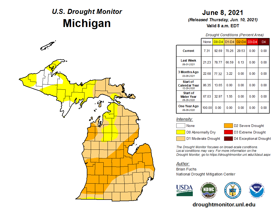
Funny enough, despite the maps, this year is definitely way worse (at least around me) based on my pastures, my soil moisture, and my ponds.
I think they are heavily over weighing our abundant early year moisture.
Hoping your reposting will cause it to rain again!!!
Maybe we all need to plan to wash our cars on the same day!!! 😉
We really need a soaking rain. Even a squall line (which we haven’t seen in forever it seems) would at least help. These brief 0.05-0.10 inch systems really are not doing anything to improve the drought
I don’t usually say this, but bring on the rain! It is becoming quite tedious watering everything, and even with the lawn irrigation, it looks pretty pitiful…
We were at Lake Michigan near Pentwater a few days ago and the “cooler by the lake” phrase certainly did not apply. With the prevailing East winds the dunes block the wind leaving the water calm as glass and the air unbearably hot out in the sun. Same coming through Muskegon where they’ve now had 3 or 4 days this week over 90 degrees. Kind of backwards from normal like this past Winter when most of the lake effect snow kept blowing over the lake shore counties and landing inland.
So far this summer it has been “cooler by the lake” on the east side of the state. It is always warmer on this side of the state with a east wind and at Muskegon they get down slopping for added warmth.
Slim
I was bummed I didn’t get my garden in this year… Now I don’t have to drag the hose every day. I did. Plant some beans in pots…hoping those will at least produce a little.
The official H/L yesterday at Grand Rapids was 85/62 as has been the case for much of this month there was no rain fall. There was 56% of possible sunshine. There were 9 CDD’s For today the average H/L is 81/60 the record high of 98 was set in 1923 and the record low of 38 was set in 1919. The record rain fall of 3.17” fell in 1989.
Slim
Looking ahead, Today should be cloudy with a chance of showers more so to the east of GR. Tomorrow looks to be the last very warm day for a while and on Sunday through at least Tuesday there is now a good chance of some much needed rain fall. It will turn much cooler for Monday and Tuesday. In fact, the forecasted highs for both Monday and Tuesday if they play out wound be a top ten for the coldest maximum for both days. We shall see.
Slim
What? More below normal temps are coming! Who would have thought? We may be reverting right back to the overall cool pattern!