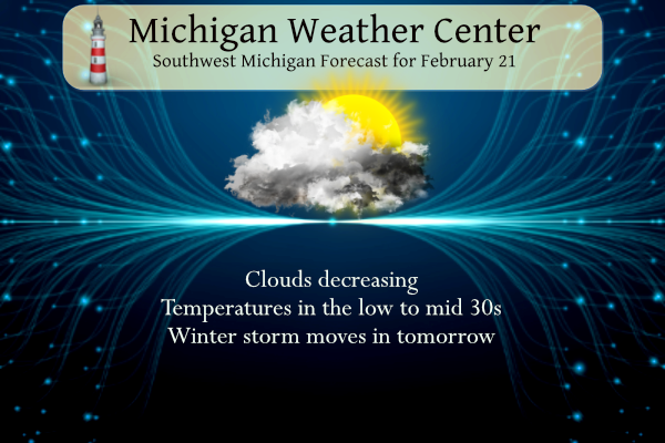
The title of this post pretty much sums it up, enjoy today for tomorrow brings a plethora (a very large amount of something, especially a larger amount than you need, want, or can deal with) of unpleasant weather into the area. Here is a summary of the current winter storm watches for the area:
Allegan-Barry-Eaton-Ingham-Van Buren-Kalamazoo-Calhoun-Jackson-
Including the cities of Holland, Hastings, Charlotte, Lansing,
South Haven, Kalamazoo, Battle Creek, and Jackson
410 AM EST Tue Feb 21 2023

...WINTER STORM WATCH REMAINS IN EFFECT FROM WEDNESDAY AFTERNOON
THROUGH THURSDAY MORNING...

* WHAT...Heavy mixed precipitation possible. Total snow
  accumulations of up to one inch and ice accumulations of
  around three tenths of an inch possible. Winds could gust as
  high as 45 mph.

* WHERE...Portions of south central and southwest Michigan.

* WHEN...From Wednesday afternoon through Thursday morning.

* IMPACTS...Power outages and tree damage are likely due to the
  ice. Travel could be nearly impossible. The hazardous
  conditions could impact the morning or evening commute.
Muskegon-Montcalm-Gratiot-Ottawa-Kent-Ionia-Clinton-
Including the cities of Muskegon, Greenville, Alma, Grand Haven,
Jenison, Grand Rapids, Ionia, and St. Johns
410 AM EST Tue Feb 21 2023

...WINTER STORM WATCH REMAINS IN EFFECT FROM WEDNESDAY AFTERNOON
THROUGH THURSDAY MORNING...

* WHAT...Heavy mixed precipitation possible. Total snow
  accumulations of 1 to 3 inches and ice accumulations of one
  tenth to three tenths of an inch possible. Winds could gust as
  high as 40 mph.

* WHERE...Portions of central, south central, southwest and west
  central Michigan.

* WHEN...From Wednesday afternoon through Thursday morning.

* IMPACTS...Power outages and tree damage are likely due to the
  ice. Travel could be nearly impossible. The hazardous
  conditions could impact the morning or evening commute. Gusty
  winds could bring down tree branches.
Mason-Lake-Osceola-Clare-Oceana-Newaygo-Mecosta-Isabella-
Including the cities of Ludington, Baldwin, Reed City, Clare,
Hart, Fremont, Big Rapids, and Mount Pleasant
410 AM EST Tue Feb 21 2023

...WINTER STORM WATCH REMAINS IN EFFECT FROM THIS EVENING THROUGH
THURSDAY MORNING...

* WHAT...Heavy mixed precipitation possible. Total snow
  accumulations of 4 to 6 inches and ice accumulations of up to
  two tenths of an inch possible. Winds could gust as high as 40
  mph.

* WHERE...Portions of central and west central Michigan.

* WHEN...From this evening through Thursday morning.

* IMPACTS...Plan on slippery road conditions. The hazardous
  conditions could impact the morning or evening commute. Gusty
  winds could bring down tree branches.
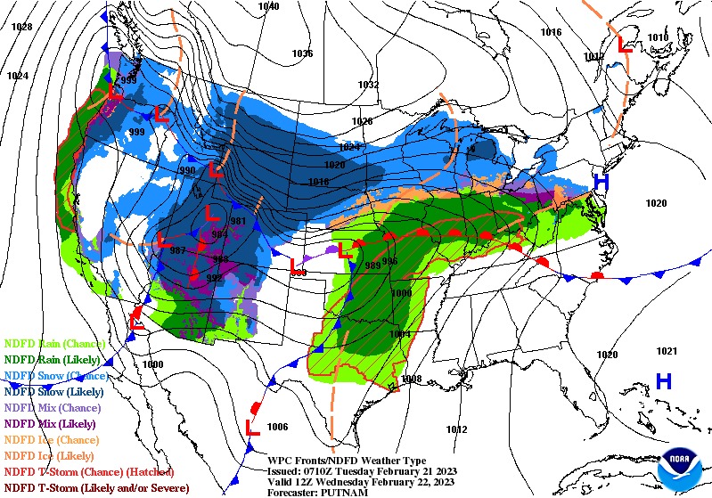
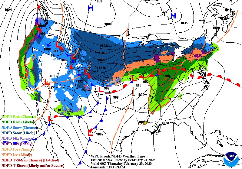
Rain, snow, sleet, and freezing rain are forecast for the area, these are the current forecast maps for tomorrow and Thursday.
Grand Rapids Forecast
2 21 grrLansing Forecast
2 21 lanKalamazoo Forecast
2 21 kzoForecast Discussion
--Dry Clipper Today --

A clipper remains on track to move through the region today with
any precipitation moving mainly through northern lower Michigan.
Otherwise clouds will bring a drabness where peaks of light will
be possible late in the day.

--Significant winter storm possible Wednesday into Thursday --

A system is on track to move through the area Wednesday into
Thursday. This will be a multi threat system  with the potential
for significant ice due to freezing rain through southern Michigan
with heavy snow possible north of I 96 and through Central
Michigan. A watch remains in effect from late tonight into
Thursday morning. Due to questions on timing and magnitude of
icing, we will hold off on any upgrades for now.

 There remains some questions on timing and of precipitation type.
The passing of the torch from the long range models to the mid
range models does not come without its complications. To ice or
not to ice, that is the question.

 That question rests upon the variables of timing, QPF and
temperature. The latest ensembles have incorporated the NAM,
which has the warmer air trending northward. This could supplant
the colder air and allow for less probability for ice to form.
This is most prevalent in Van Buren county which the timing for
ice wanes. The precipitation that comes at us like slings and
arrows makes us briefly question whether how much of a magna
glacies tempestas, great ice storm, there will be.

Looking at model soundings the 850mb is warmer where there is
higher QPF, this shows a potential shift that decreases the
amount of time for ice to manifest and keeps the highest QPF in
the warm sector. While the I 94 corridor remains colder for a time
it too could see an earlier transition to rain from freezing rain
Wednesday afternoon.

The EC/GFS is less flamboyant but has shifted the amount of ice
accumulation from freezing rain northward. The bullseye of ice
remains a quarter to near a half an inch between the I 96 and I 94
corridors. Given the latest models the time for best ice
formation from freezing rain will not be until Wednesday evening
into early Thursday. Given this development have shifted the
freezing rain northward with more rain along and south of the I 94
corridor. Gusty east to northeasterly flow will only complicate
matters that coupled with the ice could cause power outages.

The snow amounts given the shift of precipitation have diminished
though accumulations of 4 to 6 inches remains probable along a
line from Muskegon to Alma northward.

--Cold temps with lake effect to end the week --

The passage of the system will bring the bitter cold return of
winter to our shores. Highs for Friday will be in the 20s, and any
lingering water left by the storm will freeze. The northwesterly
flow that follows will not be alone as snow showers will be
possible Friday into Saturday.
We’re closed tomorrow and pretty much every district is too.
We are here too.
Already many districts closing for tomorrow. The list will only grow as the evening progresses.
No closings over here yet. I’ll be curious to see what happens in the morning with the really nasty stuff hitting later in the day. Early release, perhaps?
I see at least one is doing just that Mark..
Several are closing over here on the west side. Storm Team 8 says earlier timing for the snow and ice than earlier thought.
Yes.. sorry Kyle.. I am west sider too!!
Is winter over yet? Snow = fantastic! Freezing rain = horrendous!
100% agree. Not looking forward to my 30min commute to work the next 2 days if we get significant ice.
We still need the low pressure and the snow line to move 50 miles to the South! Bring it!
Ice Storm Warning! Potential for thunder with it as well. Wow. The so called “wimpy” winter some refer to on here has given us blizzard warnings and now ice storm warnings. Both not issued in about a decade and we got both headlines this winter.
It has been a crazy winter and plenty of winter weather left to come! Buckle up!
Local TV met just said this is our first Ice Storm Warning in nine years. Pretty rare.
Good luck everyone. I’m heading to a Hotel early tomorrow morning, as I do not trust my trees under these “extreme conditions”.
OK, in looking at the forecast for Grand Rapids there now looks like there is a chance of 1 to 2″ of snow/sleet and up to a half inch of ice with the expected winds that is not good at all
Slim
It’ll be interesting to see how closing are handled tomorrow. Most of the precipitation starts after sunrise, but I’d imagine the commute home will be terrible.
I could be wrong, but it seems that the NWS has lowered the expected ice accumulation a little bit for Kalamazoo County and moved it north somewhat.
Local TV met said Hastings to Charlotte to Mason seems like the sweet spot for up to 3/4″ of ice accumulation.
Ouch!
Definitely a crazy winter. The first Blizzard Warning in over a decade last Xmas (at least for Grand Rapids)… and the first Ice Storm warning in I think a decade?
*And* the highest number of melting events I have ever witnessed in one winter. And the sunniest February in over 40 years… lots of records this winter :O
Let’s hope the icing is not as bad as expected. Sometimes it ends up being mostly sleet or plain rain… seems like that is highly unlikely this time unfortunately
I will see how the wording is in the updated discussion from the NWS. But in what I am reading it almost looks like they are downplaying the ice and wind. It seems to me if there is a good amount of ice with 40MPH winds that would spell massive power outages
Slim
In looking at the write up I get the feeling that for some reason the NWS is kind of downplaying this event. Anyway here is some information on some past ice events in southern Lower Michigan. From channel 4’s Paul Gross, Meteorologist out of Detroit. New Year’s Eve / Day 1984-85: Of all times to get an ice storm, New Year’s Eve has to be one of the worst. Freezing rain, light at first, moved into the area New Year’s Eve afternoon, and then became heavy overnight. I was in Lansing for that one, which was hit very hard. In… Read more »
We had an ice storm in the early 2000s. I don’t know exactly what year, but I believe that was one of the more recent big ice storms
That should be the one in April 2003
Slim
I remember the 84-85 storm well. Our office was in the city of Kalamazoo where large power outages are extremely rare. It took 4 days for power to return IIRC. I do have some awesome photos I took of ice covered trees with the sun shining on them.
This was when my fear of ice storms originated.
From Bill’s Blog:
https://www.woodtv.com/weather/the-ice-storm-of-feb-21-23-1922-2/
Now that was a scary ice storm. Then there’s also the 1998 Quebec ice storm.
…WINTER STORM WARNING IN EFFECT FROM 10 AM WEDNESDAY TO 1 PM EST THURSDAY… * WHAT…Heavy mixed precipitation expected. Total snow and sleet accumulations of 3 to 7 inches and ice accumulations of up to two tenths of an inch. Winds gusting as high as 45 mph. * WHERE…Portions of central and west central Michigan. * WHEN…From 10 AM Wednesday to 1 PM EST Thursday. * IMPACTS…Plan on slippery road conditions. Areas of blowing snow could significantly reduce visibility. The hazardous conditions will greatly impact the Wednesday evening commute. * ADDITIONAL DETAILS…The heaviest snow accumulations will be near and north… Read more »
Mason-Lake-Osceola-Clare-Oceana-Newaygo-Mecosta-Isabella-Muskegon-Montcalm-Gratiot-Ottawa-Kent-Ionia-Clinton-
…ICE STORM WARNING IN EFFECT FROM 10 AM WEDNESDAY TO 4 AM EST
THURSDAY…
* WHAT…Significant icing expected. Total ice accumulations of up
to one half of an inch. Total snow and sleet accumulations up
to one inch. Winds gusting as high as 40 mph.
* WHERE…Allegan, Barry, Eaton, Ingham, Calhoun and Jackson
counties.
* WHEN…From 10 AM Wednesday to 4 AM EST Thursday.
* IMPACTS…Power outages and tree damage are likely due to the
ice. Travel could be nearly impossible. The hazardous conditions
will greatly impact the Wednesday evening commute.
They just updated… Allegan under ice storm warning now!!!
Triple UGH Mark!!
Not good. 🙁
Do you have that link you shared previously for the weather guy on YouTube?
https://www.youtube.com/watch?v=T_baO7NbVt0&t=4s
Here ya go… Ryan Hall Y’all.
Says he is going to go live when the storm comes.
How did I forget Ryan Hall Y’all?? Thanks SS.
No problem. I am not up on all weather lingo so it he explains thing in English. Lol
Double ugh
For sure!!!
Michael…do you think this could rank up there with ice storm of 1984 New Year’s Eve?
That is a good question. I do not recall it being all that windy in the 1984 event. Here in GR in 1984 there was more snow/sleet than ice. 7.6″ total event snow/sleet.
Slim
Thanks Slim. I didn’t live where we are now…but this side of town was without power for a week.
I was a kid and we went sledding … the hills were fast!!! Lol!!!
Ugh
No thank you!!! LOL!!!
Checked our generator yesterday!!!
Going to get some laundry done tonight and make some banana bread… bfast of champions!!! LOL!!
Midday forecast discussion:
https://forecast.weather.gov/product.php?site=GRR&issuedby=GRR&product=AFD&format=CI&version=1&glossary=1
I hope I will be able to get my bro from the Flint airport tomorrow evening. He’s packing some snacks in case he needs to stay there overnight.
Where is he coming in from? I wonder if things get too bad if his flight would even land
Slim
Phoenix
I’ll take snow over ice any day! Will be interesting to see how this plays out. For now, big delicious filled paczki is in the mix. Stay warm and safe!
It is turning out to be a wild wintry end to the
month of February! Last week a WWA with accumulating snow and now a WSW with possible snow and freezing rain! The cpc is still predicting a cold and snowy March! Wow to the wow!
I was late getting up today and I am still tired. The official H/L yesterday at Grand Rapids was 41/26 there was no rain or snow fall. And there was 46% of possible sunshine. The current temperature here at my house is 28 and there is some light snow falling. For today the average H/L is 35/21 the record high of 66 was set in 1930 and the record low of -8 was set in 1968 the record snow fall of 6.0” was set way back in 1898. The question now is just how much sleet and or ice will… Read more »
Morning Slim! Going to be interesting to see what happens with this. Looks like I’ll be checking map updates regularly today.
Happy to see the storm shift north. Snow totals have been reduced. More ice than snow is just another sign winter has been dying for a while now. CPC is looking warm!
So much for a cold and snowy February! It’s been a warm one, just like January.
It seems there is a slight northward trend in the freezing rain line with the overnight forecast. The WSW for Grand Rapids is now for up to 0.3″ of freezing rain… ice events are always hard to forecast so I’m sure things are still going to change a bit
The point-and-click for GR Wednesday night is interesting:
Rain or freezing rain, becoming all freezing rain after 10pm. Low around 28. Windy, with an east northeast wind 24 to 30 mph, with gusts as high as 38 mph. Chance of precipitation is 100%. New precipitation amounts between three quarters and one inch possible.
This storm is going to be very difficult to predict. There will be a sharp cut off from snow to sleet to freezing rain! The preliminary RDB gives GR 2 -4 inches of snow/sleet! Stay tuned for later updates! Rock n roll will never die! Get ready for a wild ride! Is winter weather over yet?
Happy Fat Tuesday!
More Shakespeare this morning 😀
Not looking good for tomorrow, unfortunately. Oh well, we will get through it.
Make someone smile and have a great day.
aye the paczki art eft to beest devot’d in mineth fridge! Happy fat Tuesday!
Happy Fat Tuesday! And more importantly the first day of Lent tomorrow 😀
Yessir. The Mrs. and I are going to morning Mass after dropping the boy off at school.