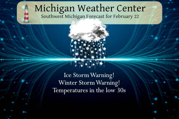
Today will be one of those days it is best to stay home and enjoy indoor activities as it won’t be much fun outdoors, to say the least. I will forgo the weather history for today because of the weather warnings in place and focus on that.
Ice storm Warnings
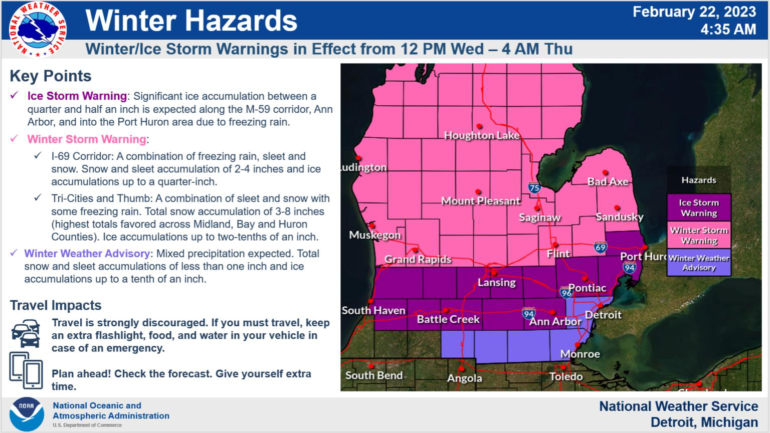
...ICE STORM WARNING REMAINS IN EFFECT FROM 10 AM THIS MORNING TO
4 AM EST THURSDAY...

* WHAT...Significant icing expected. Total Ice accumulations up
  to one half an inch. Total snow and sleet accumulations of up to
  one inch. Winds gusting as high as 45 mph.

* WHERE...Allegan, Barry, Eaton, Ingham, Calhoun and Jackson
  counties.

* WHEN...From 10 AM this morning to 4 AM EST Thursday.

* IMPACTS...Expect power outages and tree damage due to the ice.
  Travel could be impossible. The hazardous conditions could
  impact the evening commute.

PRECAUTIONARY/PREPAREDNESS ACTIONS...

Travel is strongly discouraged. If you must travel, keep an extra
flashlight, food and water in your vehicle in case of an
emergency. Prepare for possible power outages.
...ICE STORM WARNING REMAINS IN EFFECT FROM 10 AM THIS MORNING TO
4 AM EST THURSDAY...

* WHAT...Significant icing expected. Total ice accumulations of
  around one quarter to one half an inch. Winds gusting as high
  as 40 mph.

* WHERE...Van Buren and Kalamazoo counties.

* WHEN...From 10 AM this morning to 4 AM EST Thursday.

* IMPACTS...Power outages and tree damage are likely due to the
  ice. Travel could be nearly impossible. The hazardous
  conditions could impact the evening commute.

PRECAUTIONARY/PREPAREDNESS ACTIONS...

Travel is strongly discouraged. If you must travel, keep an extra
flashlight, food and water in your vehicle in case of an
emergency. Prepare for possible power outages.
...ICE STORM WARNING REMAINS IN EFFECT FROM NOON TODAY TO 4 AM
EST THURSDAY...

* WHAT...Significant icing expected. Total snow accumulations of
  up to two inches and ice accumulations of a quarter to half
  inch.

* WHERE...St. Clair, Livingston, Oakland, Macomb and Washtenaw
  Counties.

* WHEN...From noon today to 4 AM EST Thursday.

* IMPACTS...Power outages and tree damage are likely due to the
  ice. Travel could be nearly impossible. The hazardous
  conditions could impact the evening commute.

* ADDITIONAL DETAILS...Snow and sleet is expected to develop
  through this morning before transitioing to freezing rain and
  sleet by midday. Freezing rain will continue in the evening
  with significant icing occuring before tapering off Wednesday
  night.

PRECAUTIONARY/PREPAREDNESS ACTIONS...

Travel is strongly discouraged. If you must travel, keep an extra
flashlight, food and water in your vehicle in case of an
emergency. Prepare for possible power outages.
Winter Storm Warnings
...WINTER STORM WARNING REMAINS IN EFFECT FROM 10 AM THIS MORNING
TO 4 AM EST THURSDAY...

* WHAT...Heavy mixed precipitation expected. Total snow and sleet
  accumulations of 1 to 3 inches and ice accumulations of up to
  four tenths of an inch. Winds gusting as high as 50 mph.

* WHERE...Portions of central, south central, southwest and west
  central Michigan.

* WHEN...From 10 AM this morning to 4 AM EST Thursday.

* IMPACTS...Power outages and tree damage are likely due to the
  ice. Travel could be nearly impossible. The hazardous
  conditions could impact the evening commute. Gusty winds could
  bring down tree branches.

PRECAUTIONARY/PREPAREDNESS ACTIONS...

If you must travel, keep an extra flashlight, food, and water in
your vehicle in case of an emergency.
...WINTER STORM WARNING REMAINS IN EFFECT FROM NOON TODAY TO 4 AM
EST THURSDAY...

* WHAT...Heavy mixed precipitation expected. Total snow
  accumulations of 4 to 8 inches and ice accumulations of up to
  one tenth of an inch. Winds gusting as high as 40 mph.

* WHERE...Midland, Bay, Huron, Saginaw, Tuscola and Sanilac
  Counties.

* WHEN...From noon today to 4 AM EST Thursday.

* IMPACTS...Travel could be very difficult. The hazardous
  conditions could impact the evening commute.

* ADDITIONAL DETAILS...Light snow early this morning ramps up by
  early afternoon, and will likely mix with sleet and perhaps
  freezing rain Wednesday evening and night.

PRECAUTIONARY/PREPAREDNESS ACTIONS...

If you must travel, keep an extra flashlight, food, and water in
your vehicle in case of an emergency.
...WINTER STORM WARNING REMAINS IN EFFECT FROM NOON TODAY TO 4 AM
EST THURSDAY...

* WHAT...Heavy mixed precipitation expected. Total snow
  accumulations of 2 to 4 inches and ice accumulations of one
  tenth to one quarter of an inch. Winds gusting as high as 35
  mph.

* WHERE...Shiawassee, Genesee and Lapeer Counties.

* WHEN...From noon today to 4 AM EST Thursday.

* IMPACTS...Power outages and tree damage are likely due to the
  ice. Travel could be nearly impossible. The hazardous
  conditions could impact the evening commute.

* ADDITIONAL DETAILS...Snow is expected to develop later this
  morning and change to sleet and freezing rain by afternoon.
  Sleet and freezing rain will then continue during the evening
  before tapering off Wednesday night. Significant icing is
  expected.

PRECAUTIONARY/PREPAREDNESS ACTIONS...

If you must travel, keep an extra flashlight, food, and water in
your vehicle in case of an emergency.
...WINTER STORM WARNING REMAINS IN EFFECT FROM 1 PM THIS
AFTERNOON TO 7 PM EST THURSDAY...

* WHAT...Heavy snow and blowing snow expected. Total snow
  accumulations of 6 to 12 inches with locally higher amounts
  possible. Heaviest snow expected later this afternoon through
  tonight. Possible ice accumulations of a light glaze. Winds
  gusting as high as 40 mph.

* WHERE...Northern Lower Michigan.

* WHEN...From 1 PM this afternoon to 7 PM EST Thursday.

* IMPACTS...Travel is expected to be very difficult, especially
  tonight into Thursday morning. Expect slippery, snow- covered
  roadways. Blowing snow will significantly reduce visibility.
  Hazardous conditions will likely impact this evenings and
  Thursday morning commutes.

PRECAUTIONARY/PREPAREDNESS ACTIONS...

If you must travel, keep an extra flashlight, food, and water in
your vehicle in case of an emergency.
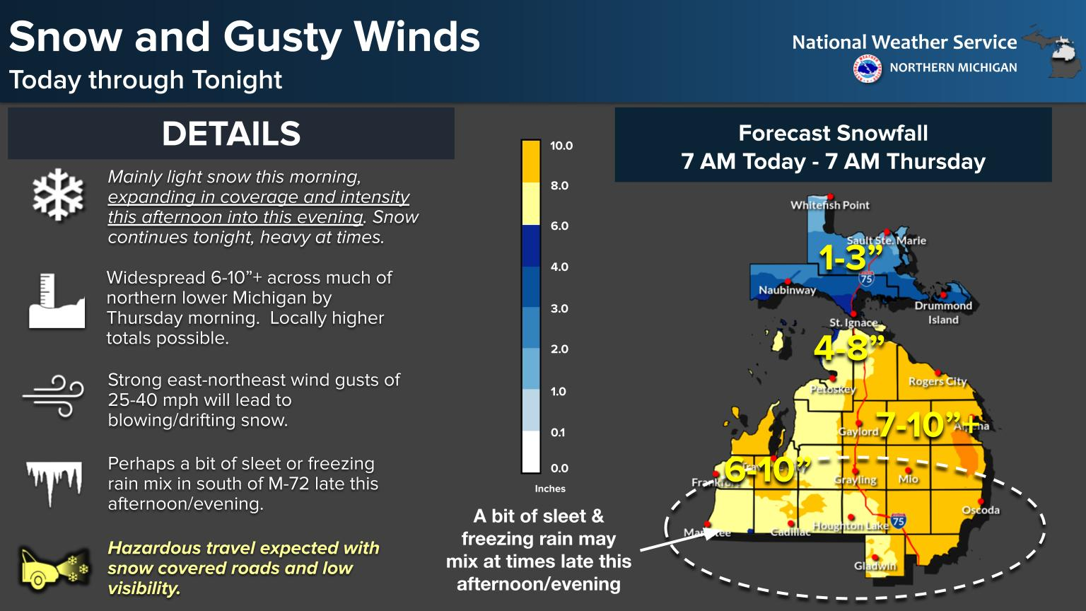
While mainly light snow is expected this morning, snow is expected to expand in coverage and intensity this afternoon and evening. Snow continues tonight, heavy at times, across much of northern lower Michigan. Additional snow/sleet expected on Thursday. Hazardous travel is expected with roads becoming snow-covered and periods of very low visibility.
Grand Rapids Forecast
2 22 grrLansing Forecast
2 22 lanKalamazoo Forecast
2 22 kzoForecast Discussion
-- Significant Ice and Winter Storm Arrives Today --

The Winter storm that has been discussed for the last week arrives
today. An Ice storm warning remains through the southern two tiers
along and just above the I 94 corridor. A Winter storm warning
then will continue through the rest of the Lower Peninsula.

 The changes to the forecast is the timing of the arrival of
precipitation. Based on the latest CAMS, especially the HRRR, the
precipitation through the south should intensify between 7AM and
9 AM along the I 94 corridor and between 9 AM and 11 Am along I
-96.

 The main threats for this storm remain the significant amount of
Ice between I-96 and I-94, the mix of freezing rain and sleet
along and just to the north of the I-96 corridor and heavy
snowfall through Central Lower Michigan. I will go through each
specific concern below beginning through the South and working
northward.

--Ice Threat through Southern Michigan --

Latest HiRes guidance continues to increase the timing of the
incoming precipitation. This is to be expected. Current
temperatures across the region are in the low 30s to mid 20s.
These sub freezing temperatures are optimum for ice accumulation.
The QPF during the morning and early afternoon should be a tenth
to two tenths. Given the cold temperatures and low dewpoints this
freezing rain should bring ice accumulations along the I-94
corridor.

 Looking at the latest RAP and HRRR there is some concern that
temperatures will become marginal this afternoon and evening,
especially in the timeframe where QPF is expected to be over 1"
and even as high as 2". However, moderate temperatures aloft could
allow the rain to freeze and fall as sleet.

Even if temperatures are somewhat marginal the wet bulbing
effects related to heavier precip rates and mid to upr 20 dew pts
will lower them below freezing. However the area near and south of
I-94 corridor could be marginal for rain vs freezing rain and we
currently have the highest ice amounts over the north portions of
the I-94 corridor counties.

While there remains questions where the only answers lie in some
undiscovered country, there will remain impactful precipitation
through the daytime and through at least the first half of
Wednesday night.

The other complicating factor will be the strong low level winds.
A 50-70kt low level jet remains projected to fly northward from
the Gulf and bound upwards over the warm frontal slope with strong
upper level divergence in the right entrance region

Heaviest QPF will be between 18Z and 00Z with the heaviest
Freezing rain/sleet still expected between I 96 and I 94
corridors. The Fcst soundings continue to show an approximate
"bullseye" of highest icing amounts impacting the area from
Hastings to Charlotte to Mason. Elevated instability this
afternoon with decent CAPE and coupled with the above mentioned
shear should support some thunder and lightning during the ice
storm. So gusty winds and increased precipitation will be possible
in any thunderstorms. This will only increase the potential for
impacts this afternoon and early evening.

Precipitation shield should lift northward late tonight, early
Thursday with only light precipitation in its wake, though there
remains a chance for freezing drizzle based on the stratiform that
will remain.

--Heavy Sleet/Freezing Rain near/north of I-96--

Northward to a land that soon will be enveloped with ice and snow.
The forecast soundings of the HRRR/NAMnest show a strong
preference for more sleet, being more firmly/deeply entrenched in
the low level cold/dry air but also still having an influx of
warmer air aloft. These conditions area expected from M 46 down
to I 96. An inch or two of sleet with some snow mixed in will
make impacts to travel a concern but make power outages less
likely. The winds will infiltrate here the most which will give
the region the stronger winds. Gusts potentially upwards of 45 to
50 mph. No change in headline expected.


--Snow along and north of U.S. 10--

The influx of warm air continues which the models have shown to
dampen what was thought to be large snowfall totals. So even
through some sleet will inevitably mix in, there remains the
likelihood of 5-7 inches along and north of Highway U.S. 10 with
lesser amounts to the south. Blowing snow will probably become a
factor in this area though with gusts to 40 mph with occasional
whiteout conditions. Precipitation in northern sections should
linger into Thursday morning

--Brief warmup Thursday but coupled with high winds--

Power outages from icing remain a big concern. The warm air that
will advect into the region will bring at least a brief period of
warming is with Thursday temps bumping upwards into the 40s.
This is shortlived as temps plunge back into the teens Thursday
night. The northwesterly flow of the exiting system will bring
gusty winds late Thursday with wind gusts upwards of 45 mph
possible.
Ice now really starting to build up here mixed with some sleet still. Went out to look at the branches and they are coated. Not enough to bring limbs down yet but lots of buildup in the past hour
Very weird… We have liquid puddles, icy yard that is white from whatever fell. Ice is forming on trees and the pine needles are iced over.
Is it supposed to be windy tonight??
20 mph gusting to 40!
Ugh!! I thought so and even tomorrow I think with warmer temps?
At my house there is a nice coating of ice on the car. There’s more freezing rain mixing in with the sleet now than there was before dark
Just went outside to check the accumulation on our son’s car. There is a thin layer of ice on the car but more sleet piled up on top of that layer. Local TV mets at 6pm said we could get an additional 1/4 – 1/2” of ice before it’s all said and done.
Almost 30,000 consumers customers without power. Majority along and south of 94. Outages popping up around Kalamazoo now
Up to 52k now. Yikes.
https://www.consumersenergy.com/outagemap
For those of you that think it is not too bad outside, you are wrong! 4:30 pm officials in Kent County recommend not driving unless absolutely necessary! Accidents and slow travel all over the place and the ice is building up! Stay off the roads!
Current conditions =30 degrees with a snow, sleet, freezing rain mix! We are up to nearly 2 inches of snow already! Wow just wow!
Hey, we’re not the only ones dealing with nasty winter weather. I’m watching Ryan Hall Y’all (thanks SS!).
Los Angeles County is under their first ever issued Blizzard Warning. Up to seven feet of snow forecasted for higher elevations. Mt. Baldy ski resort may end up getting upwards of 100 inches of snow from this storm. They’re calling it a once in a century event.
I have been watching on and off too. With tornado warnings to the south as well. It is pretty crazy!!!
My dad said he’s had freezing rain where he is in Potterville but doesn’t notice much on trees
We are still getting plastered with moderate snow. All snow so far! I love it!
In looking out the window there is some light freezing rain falling with few grains of sleet but so far nothing really out of hand. Can not say what the roads are like but in looking don’t look real bad. 30 here at the current time.
Slim
Pretty quiet here for the past two hours. We went to Mass at noon and then out to lunch on the way home. Pretty slick on the way to church but now the roads are okay. I’m expecting conditions to deteriorate this afternoon. 30 degrees here currently.
My bro’s flight was canceled. Bummer that we don’t get to see him, but it saves me the trek to Flint.
I have not been outside but in looking out the windows it really don’t look all that bad here at this time. The ground is white and there is some ice on the side windows of the car in the driveway but I can not see much if any ice on the trees.
Slim
Based on how few power outages have occurred so far, it does not seem to be too bad yet. That’s typically a good indicator
Steady rain continues, freezing on everything. Our driveway is one long, downhill ice rink. Just put out 35 pounds of salt on it. That’s more salt than I’ve used this entire Winter.
At the current time here I am getting some light freezing rain with some snow mixed in. The ground is white but not much has fallen as of yet. With a temperature of 30 and some wind.
Slim
This storm is just starting to get revved up! The roads are hazardous and going to get worse!
Wow, just wow!
Heavy wet snow in mount pleasant. 2” have already fallen. Thankfully it’s all snow for now.
There is a pretty large slug of moisture to our southwest. All of it is pointed at SW Michigan. How much ice will we receive? Well that remains to be seen obviously.
Not too bad out there yet. Traffic is slow but moving. Mainly sleet.
GR just very windy with light freezing on some surfaces. No precip at the moment. “Doubt” starting to creep in.
There is a pretty decent amount of moisture moving in from the west. Seems like it should pick up soon… we will see
Also there are not too many outages yet. One just NW of Walker and another in Allegan county
Just arrived home. Drove from Allegan County east through Barry and Eaton County and it was mostly freezing rain along the entire stretch. About 3 miles from my house I got into some sleet accumulations so at my house so far it’s been mostly sleet with a light ice glaze.
That’s quite the big push of moisture over Lake Michigan. Hopefully most of that falls as snow/sleet instead of freezing rain
I drove from Bradley in Allegan County east across Barry Eaton and then home. There are some street signs already with icicles hanging from them. If this incoming moisture falls as freezing rain which some areas it will could get lots of ice buildup fast
Trying to decide on keeping the cocktail bars open tonight. Will salt and plow trucks keep up? Time will tell. Also, ice pellets in Kentwood now. Lull in the action for the moment.
Over a inch of new snow has fallen in the last hour temp is 27 degrees currently in my hood at the Airport GR reports heavy snow fallen the snow just keeps adding up!! INDY
What a storm, what a winter! Rock n roll will never die!
Current seasonal snowfall for GR is 84.5 inches and the normal to date is only 64.5 inches! Way above normal and counting! Incredible snow this year so far! Keep it rocking!
We are already above the SEASON average as well. Anything else we get is bonus
Dont forget the record snow days we have I believe we are pushing 6 of them this winter crazy… let it snow let it snow let it snow … Great call NWS on the winnter storm warning…INDY
Today is our second snow day.
There are already icicles hanging from the street signs here in Bradley. Allegan County
Fun fact….GR is now below average for snowfall for met Winter. How can that be?!
https://forecast.weather.gov/product.php?site=GRR&issuedby=GRR&product=CLI&format=CI&version=1&glossary=0
What a winter! GR well above snowfall and now more snow today, next week and beyond! Wow just wow!
Hey Mark.. Ryan Hall is going live to talk about weather at 12:30… Just fyi…
Thank you!
Just got back from Holland….had sleet for about 10 minutes and now a steady rain. Had to pull off the road for a minute to let the defroster warm up the front window and melt the ice forming on it. More Winter rain. I’d like to know how many days this Winter had snowfall and how many had rainfall. I think the number of rain days has exceed the number of snow days.
I am at a gas station down in the Bradley area in Allegan County and it’s 28 degrees with solid liquid precip. I will add I had lots of sleet heading south until about M6 I got into more freezing rain
Currently snowing hard out in my hood just adding on to a above normal Wimter woo woo!! InDY
Breaking>>>>>all of the teleconnectors are trending towards a transition to more cold and snow well into March! Wow, just wow!
Ice pellets have started to fall here. 🙁
Winter storms through April great scotty …INDY
The snow and sleet has begun! Lows in the teens Thursday and Friday night and then more cold and snow next week! What a winter and it could be wild for the next few weeks! Incredible!
I honestly think it is a bit confusing why Kent is not in the ice storm warning. Most people do not follow the weather closely and might see “winter storm warning” and think snow, even though Kent is supposed to see 1-3 inches of ice pellets and 0.1-0.4″ of freezing rain. Just my opinion 😀
The main reason is that Kent County will be seeing more snow and sleet than the Southern counties, therefor less ice, if Kent was in an ice storm warning people may not prepare for the snow and sleet that we are getting as we speak! We are getting pummeled with snow right now
We keep on changing between different precipitation types here. It was just snowing 5 minutes ago, now it is a light drizzle. I heard a few ice pellets… but so far it has been switching between pure snow and pure drizzle
What a sloppy day. Whatever we do get looks to melt tomorrow. Some 50’s near the Ohio/Indiana border tomorrow. This is winter?
Freezing rain and drizzle has moved into Otsego – temperature is 30 degrees
A little to your north and the drizzle is a light rain right now. Our deck boards are starting to get icy.
Starting to get some drizzle here.. winds are gusting .. report from dog walk. Lol
I still have a somewhat runny nose. Yesterday the official H/L was 39/26 there was 0.01” of rain/snow fall. There was a reported 26 minutes or 4% of possible sunshine. There overnight low here in MBY was 26 and there was enough snowfall to cover the ground. At the current time it is cloudy and 28 here in my yard. For today the average H/L is now up to 36/21. The record high of 67 was set in 1930 and the record low of -7 was set in 1936. Todays record snow fall amount of 4.9” was set in 2010.… Read more »
The average high is finally starting to increase at a decent rate. Pretty soon anything in the 30s will be considered below average
I really hope this isn’t as bad as it could be.
Anyone else catch the Hamlet reference in this morning’s forecast discussion?
I kind of like the new persons write ups.
Slim
Me too. I wasn’t so sure at first, but I’m kinda digging it.
At least it is translated from old English from Shakespeares time
Lots of lightning being reported in central Indiana this morning the warm air is close but no cigar …..Quite a temperature divided means big Winter storm is near ….INDY
Hey Indy just for fun – Ck out this map! It has been a wild winter with above normal snowfall and plenty more to go! Wow to the wow! Let’s keep the cold and snow rocking till April!
https://www.tropicaltidbits.com/analysis/models/?model=gfs®ion=us&pkg=asnow&runtime=2023022206&fh=384
50 MPH Winds with snow sleet and freezing rain this definitely could end up as a historic storm already 100’s of schools closed next busineses will be closing many power outrages hold your hat stay safe what a Winter we are having wow to the wow …..INDY
The words of the day! “Slow down and be carful”!