
Yesterday was a nice respite from the rain, we had a couple of brief showers but the sun made an appearance which was a sight for sore eyes. I managed to get some grass cut with my lawn tractor, I wouldn’t have liked to try it with a regular push mower as it was pretty tall – still had to rake up the clippings though. I also finally got to put down my summer application of fertilizer. On a side note over my many years of keeping fine lawns, I found that moles hate fertilizer, it tends to make them move to the neighbor’s lawns, much to their chagrin. Ants have been the biggest problem this year which I have kept at bay with granular insect killer.
We once again have some showers moving through this morning. Showers and thunderstorms will increase in coverage from yesterday and are expected to become numerous by afternoon and evening for areas near and south of the I-96 corridor. Storms will contain very heavy downpours and could renew or worsen ongoing flooding. Gusty winds will also be possible and could blow around loose objects or drop large tree limbs. There is a marginal risk for storms.
Most of southern Michigan continues to be under a flood warning until 1 pm today, wouldn’t be surprised to see this continued due to the possibility of heavy rain in the forecast. We have chances of rain through Thursday.
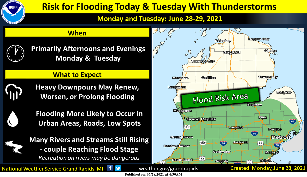
Numerous showers and thunderstorms are expected today and Tuesday, especially for areas near and south of the I-96 corridor. The rain is not expected to be continuous, but we will see occasional heavy downpours which could lead to localized flooding. Flooding is more likely to occur anywhere water has recently receded.
>For more info on the tornadoes, last week check out Bills blog.<
Forecast Discussion
- Risk for locally heavy rain into Tuesday

PWAT values climb back up to around 2 inches across the CWA Today
into tonight and remain that way into Tuesday night. This axis of
moist air remains nearly parallel to the mid to upper level flow.
To start an area of showers and thunderstorms with locally heavy
rain was lifting northeast towards the CWA from IL and IN. Overall
though the forecast calls for them to weaken as the move in.
However they have persisted longer than the models have been
showing so it appears the setup for rain is better than predicted.
The new High Res Euro may be onto that showing swaths of locally heavier
rain over the next couple of periods. Guidance still shows a weak
low level jet forming this afternoon across IL and moving into MI
on Tuesday. The atmosphere is shown to be unstable. Given the
moisture...lift and instability...a risk for locally heavy rain
is predicted for much of the CWA into Tuesday night. With the soil
saturated from the recent heavy rain events and stream still
flooding or near bankfull...it will not take much to initiate new
flooding especially where any storms repeat over the same
location.

- Isolated severe storms possible Tuesday

Deep layer increases slightly across the CWA Tuesday with a
potential for decent instability in the afternoon. The area will
be on the south side of an upper level jet with diffluence noted.
A weak surface front pushes in from the northwest later in the
day. Thus an increased potential for thunderstorms is predicted. A
few of these storms could feature strong winds that could perhaps
reach severe levels.

- Cooler for the end of the week...more rain?

All models show a considerable cool down for the end of the week
with Friday likely to be the coolest day. However...while most
models show little or no rain...the GFS now has bands of rain
associated with this mid to upper level low dropping down from
Ontario mainly Thursday afternoon into Saturday. The GFS actually
cuts off this low and stalls it over the Western Great Lakes
region Friday into Saturday... which would not be good. With the
GFS being an outlier...we will not use it with this forecast
update...however the trends will need to be monitored closely.
Had a heavy shower here and then a nice rainbow. 76 here now after the shower.
Slim
Well that was fun…one single flash overhead, and then the instantaneous, house shaking crack/rumble 😉 Very heavy downpour at moment…great, more rain.
3 minutes = 4/10…quite a downpour.
I tried to get a photo of the rainbow but non stop thunder.
Had the rain and rainbow here but the lightning was too far away and just see a small flash to the east with no thunder.
Slim
Rainbow was beautiful! It was a double one.
Storm is letting up. Much brighter. The sun is actually coming out some.
The sky is so dark here. Thunder and lightning. Wind is kicking up . Severe thunderstorm warning up for Allegan and Ottawa county till 8:30 pm.
Oh gee, another severe thunderstorm warning for Ingham county. Lots of CTG lightning. Very loud. The windows are rattling. Of course, heavy rain too.
Boy it feels ugly outside again today. Dew point at 72 and the heat index closing in on 90 again.
Good looking storm passing to our SE. Can hear thunder, as well as, lightning static on radio 😉
It’s only June and Michigan has now had 7 tornadoes!
Been loving this nice and warm June with lots of thunderstorms. Perfect weather!
Yes perfect weather is right no big heat waves in sight!! Welcome back to blog its been a wet one!! INDY
The jet stream and our current weather is being influenced by the record heat out west. So while we’ve been warm, the western US has been HOT.
Guess what??? There is a light rain shower ongoing at this time. So far just 0.02″ has fallen. The overnight low here was 62 and the official low at GRR looks to have been 61. With an official rain fall total at Grand Rapids of 8.40″ this is now the 2nd wettest June of record. The reported record of 13.22″ in 1892 should be safe but that was a long time ago and one has to wonder about the record keeping. At this time it is 65 here with light rain falling.
Slim
Seattle hit 104 yesterday, which broke their all time high record of 103 set in 2009. Oh and by the way, they are forecasted to hit 110 today.
Fun (or not so fun) fact: approximately 30% of Seattle residents have air conditioning.
At Spokane the forecast is for highs of 100 or better to the upper 90’s for the rest of this week. While at Seattle as you said near 110 today with a “cool” down into the upper 80’s to low 90’s the rest of the week.
Slim
I also mowed yesterday. It was a sloppy wet mess. Ants were bad yesterday here too. There were thousands (millions?) along the seam in the concrete of our driveway just outside of our garage. Tip: I spray them with starting fluid. Kills them instantly and does not stain the concrete.
Several Ant “eruptions” in the yard…new to us. Maybe the rain is forcing them up and out?