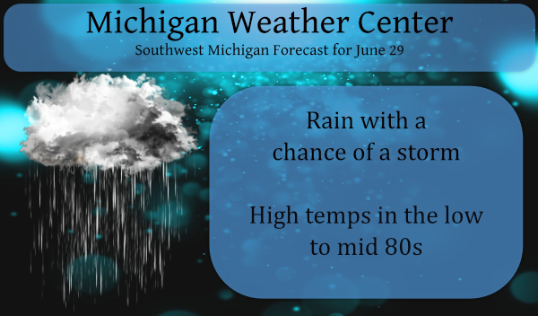
We had another .32 of an inch of rain yesterday to add to our total for the soggy second half of June which brings us to 8.8 inches for the month (these are Otsego totals). Humidity was the main factor for our rain yesterday with the soggy atmosphere driving rain into the area. Our high temp yesterday was 83° with a 77° dewpoint. With the air conditioning on inside the windows of our house fogged up almost to the point of being unable to see outside.
Working outside was not fun, to say the least. Hats off to those who have to tolerate this on their jobs, keep ice water on hand. Believe me, I know how you feel, I have worked in paper mills, on farms, and in construction in my younger days.
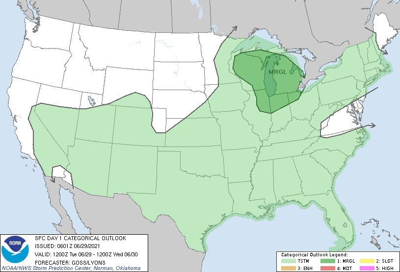
Today will be another rerun of previous days with the humidity in place it shouldn’t take much to set off a rain shower. Our rain chances are around 60% for today and tomorrow. The SPC has us with at a marginal risk for severe weather today:
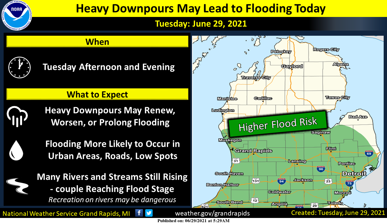
Numerous showers and thunderstorms are expected today. Thunderstorms are likely to produce heavy downpours, especially near and south of the I-96 and I-69 corridors. This is also where the most rain has occurred since late last week. The downpours may lead to localized flooding, especially if an area experiences prolonged rainfall or multiple thunderstorms. Flooding is also more likely to occur in places that recently flooded.
Forecast Discussion
- Thunderstorm and heavy rain risks into Wednesday

PWAT values will generally remain around 2 inches through Tuesday
night before the front pushes in on Wednesday. The flow remains
southwest through a deep layer then becomes more west southwest as
the front arrives. A low level jet is over the region to start the
day and has helped to produce the storms tracking through the
area. This low level jet does stay over Lower MI through the day
today...but we do end up on the west side of this feature. This
typically in not the most favorable location enhancing storm
development. However the mid to upper level trough moves in later
today and more so tonight. The synoptic lift associated with this
feature should help to increase the storm development. Deep layer
shear is strongest across the north half of Lower MI so perhaps
some organized convection could get going there. Given the high
pwat airmass and unidirectional flow...locally heavy rains look
possible.


- Heat index values into the 90s southeast this afternoon

With air temperatures rising into the upper 80s and dewpoints in
the low 70s...this afternoon will likely feature heat index values
into the 90s for southeast parts of the CWA.


- Cooling down Friday into Saturday

Model guidance shows a pattern shift for the end of the week.
Northerly flow develops Thursday and persists into Saturday. This
cold air advection will support below normal temperatures
especially Friday. The High Red Euro 925 mb temps lower to 10 to
12 Deg C which should keep high temps at or below the mid 70s.
Thundering again. I don’t recall a weather pattern like we’ve had lately.
Sheesh, it’s storming like mad here right now. Wind, lightning, and torrential downpours. The street is a river once again.
Mark, the storms in you area also have the most lightning strikes of any of the storms this last few weeks.
Slim
Two weeks ago, I was yearning for some storms. I’ve had my fill. I’m ready for a sunny and dry stretch.
It’s been a wet end of the month thats for sure above average rainfall and only 1 recorded 90* degree day in June that’s greeeattt with me to!! Also not seeing any big heat waves in sight the muggys are fine with me just keep the 90’s+ away and that’s my June report!! Happy July we are only 179 days away from Christmas!! Days are getting shorter!! INDY
Must be the lake breeze or something. We’ve had four 90-degree days here this month.
Officially Grand Rapids has had 2 days with a high of 90. Yes, Lansing has had 4 days of 90 or better with the highest of 94. Holland and Muskegon have not officially had a day of 90 or better yet.
Slim
A dew point of 84 on the other side of the state??? Cmon, this is getting insane!!
http://www.usairnet.com/weather/maps/current/michigan/dew-points/
I did not see a DP of 84 anywhere in Michigan there is a report of a DP of 77 in the downriver area south of Detroit and several locations of a DP of 75 and 73 officially at Grand Rapids. I have a DP here of 74. The highest I can see in the US is near Jacksonville FL with a DP of 83. Yes it is rather humid today. But then again I have been in Florida in the summer and it feels much worse down there.
Slim
It is gone now. I should have screenshot the page. It was over near Detroit.
Tons of heat, storms, and tornadoes for June. And plenty of sunny days throughout as well. I’ve loved the start of summer!
“Hey, hey, hey!”
– Freddie “Rerun” Stubbs
With yesterdays 0.12″ of rain that brings the total for this long event here at my house at 6.1″ and I would say that for much of this area the drought is all but over. Officially at GRR they reported 0.08″ of rain yesterday and now have a total of 8.48″ for the month. The official amount for the year is now at 17.03″ that is still a departure of -1.68″ for the year to date. The mean temperature for June remains at 70.5 that is a departure of +1.9 so June 2021 will end up warmer that average. At… Read more »
Dew point up to 77 yesterday? Yuck. This tropical air mass is getting rather annoying. We did have the best lightening show of the year so far last night. And another .62” of rain. 👎
Had some rain here but the thunder and lightning was off to the south then east. Still few (if any) real thunderstorms here in the northern part of Grand Rapids.
Slim