Yup, you read it right – more rain especially south and southeast of Grand Rapids. You might hear a couple rumbles of thunder but nothing to wake the Skywarn Spotters, we will save that for the weekend when, you guessed it, more rain and perhaps some storms when a warm moist airmass moves in. Our best chances of seeing some sun for any period of time will be Friday and next Tuesday.
Weather History
June 16
1974: Cool and cloudy weather prevailed for the middle of June with high temperatures only in the middle 50s across the region on both June 16th and 17th.
June 17
1975: A tornado struck two miles northeast of Newaygo. A tree fell on and killed a 14 year old girl who was camping with her parents. Tornadoes also hit Roscommon County, where damage was done to some boats on the southwest shore of Houghton Lake. Another tornado damaged several farm buildings north of Zeeland in Ottawa County.
1992: Over a dozen, mostly weak tornadoes struck across Lower Michigan, including south of Coopersville in Ottawa County, near Cedar Springs in Kent County, Harrison in Clare County and Pewamo in Ionia County.
June 18
1976: Three tornadoes cause minor damage across Lower Michigan. The first tornado moved northwest of Lansing, damaging a house and destroying a barn and shed. Another tornado blew down barns near Reese in Saginaw County. The final tornado destroyed a barn and damaged a garage in Gladwin County, north of Edenville.
1994: An early season heat wave peaked with temperatures in the mid and upper 90s across the region. The temperature hit 98 at Lansing, 96 at Grand Rapids and 91 at Muskegon.
June 19
1954: A tornado strikes in Jackson County at Gillett’s Lake, damaging several houses and cars but causing no injuries.
1995: Muskegon hit 98 degrees, their highest temperature on record in the month of June. Their second hottest June reading of 95 degrees would occur the following day.
2009: Severe weather strikes with three tornadoes and downburst winds. A tornado partially unroofed a home south of Allegan and another tornado took the roof and deck off a home near Richland in Kalamazoo County . A weaker tornado downed trees and did minor damage to a house in Alamo Township, Kalamazoo County. I remember this one – the funnel clouds passed just south of Otsego.
June 20
1953: An early summer heat wave peaked with temperatures around 100 degrees. It was the hottest June day on record at Grand Rapids with a high of 102 and a sultry low of 79 degrees.
June 21
1988: The hot summer of 1988 got off to a sizzling start with record highs of 98 degrees at Grand Rapids and Lansing.
1996: A tornado struck from near Weidman to west of Rosebush in Isabella County. Three homes were damaged and four barns destroyed, along with several other outbuildings. Several silos and farm machinery were damaged. Other tornadoes hit near Frankenmuth and Imlay City.
June 22
1957: At least four weak tornadoes hit southern Lower Michigan. At Hudsonville in Ottawa County, damage is down to a warehouse. A barn is destroyed near Pinconning in Bay County. Several barns are damaged or destroyed in Berrien and Cass Counties. Trees are taken down at Dumont Lake in Allegan County.
1992: One of the coldest summers on record in west Michigan got off to a freezing start with frost and freezing temperatures across the region. At Muskegon the temperature plummeted to 32 degrees. It was the latest freezing temperature on record there.
2015: Severe thunderstorms with brief tornadoes and downbursts strike across Lower Michigan. Portland, Michigan is hit by a small tornado with winds estimated over 100 mph.
June 22-23, 2015 Tornado & Severe Weather Event
An active 24 hour period unfolded across Southeast Michigan on Monday afternoon and into early Tuesday morning. Two different rounds of severe weather hit the area, with the first round sweeping a MCS (Mesoscale Convective Complex) Monday afternoon and the second round coming across late Monday night. The second round of severe weather brought 4 tornadoes to Saginaw/Tuscola, Sanilac, St. Clair, and Washtenaw counties. Damage surveys were done and the results can be found below. Damage from the tornadoes ranged from EF0 to EF2.
First radar loop is the first round of thunderstorms that rolled through Monday afternoon and the second loop is the second round of severe weather that occurred late Monday night into early Tuesday.
[columns] [span6]

[/span6][span6]

[/span6][/columns]
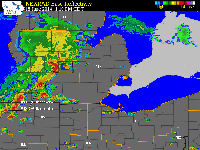
June 18, 2014 Severe Weather Event
Southeast Michigan saw active weather in both the morning and afternoon on Wednesday, June 18th, with the afternoon convection turning severe. Previous convection during the morning hours had moved off and there was enough instability for the thundersorm complex over southern Wisconsin and northern Illinois to hold together as it crossed Lake Michigan and into lower Michigan. This line of storms raced across the state bringing winds, heavy rain, and frequent lightning with numerous reports of trees down, power outages, and local flooding.
June will make it 6 months and counting with below normal temps! An incredible pattern!!!!
Perfect summer! My flowers are loving it.l
Overcast with rain inbound…imagine that.
who knew?
GR is at 79 degrees right now. WOOD forecasted a high of 72 today. Another missed forecast.
GR unexpectedly hit 81 degrees yesterday! Very mild morning in the 70’s today.
While the start of summer 2019 has been on the cool side it sure is nice and green. Not sure if it will stay this way all summer but as of now things look real nice. (note many farmers do not have the same felling as planting might still be way behind) The current temperature here at my house is 59 with cloudy skies. Talking about cloudy cover here is the take from the NWS office here in Grand Rapids 8 = SMOKE OR HAZE [NO. OF DAYS WITH] [WEATHER – DAYS WITH] 9 = BLOWING SNOW X = TORNADO… Read more »
Some farmers have decided to not plant their corn as it is getting too late.