We will continue to have smoke in the air today though not as bad as yesterday. Fires in Canada have burned 20 million acres thus far which is an area nearly as large as South Carolina, according to the Canadian government. For me, this is a mind-boggling stat to wrap my head around. Most of the fires were caused by lightning and carelessness with campfires.
We will have a warm and humid airmass in place today with temperatures rising into the upper 80s to near 90°.
Unless we get some rain today in Otsego we will end the month with .84 inches, nearly three inches below normal.
U.S.A and Global Events for June 30th:
1792: The first recorded tornado in Canadian history struck the Niagara Peninsula between Foothill and Port Robinson, leveling some houses and uprooting trees between the communities.
1900: The combination of high winds and the presence of wooded fuel-filled cargo helped to spread fire on the Hoboken Docks in New Jersey. The fire began when cotton bales caught fire and spread to nearby volatile liquids. The fire killed at least 300 people and was seen in New York City.
1912: An estimated F4 tornado ripped through Regina, Saskatchewan, Canada on this day. The storm became the deadliest tornado in Canada’s history as it killed 28 people along a rare, 18.5-mile track from south to north.
1999: Mount Baker, Washington closed out a record snowfall season both for the United States and the verifiable world record as the seasonal total from July 1, 1998, to June 30, 1999, finished with 1,140 inches.
Grand Rapids Forecast
6 30 grrForecast Discussion
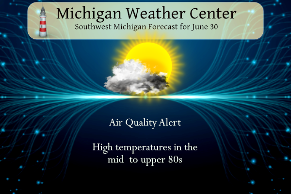
.SHORT TERM...(Today through Saturday)
Issued at 349 AM EDT Fri Jun 30 2023

An Air Quality Alert continues today for wildfire smoke for much
of the area and is for both wildfire smoke and ozone for Muskegon,
Ottawa, Kent, Allegan and Van Buren counties. PM2.5 numbers have
improved this morning however due to some westerly flow as well as
the rain. The west flow today should overall improve conditions
as we work through the day, but numbers are still not great with
PM2.5 AQI values in the 150s at this hour.

We will be watching the threat of fog developing across much of
the forecast area this morning with moisture in place both from
rain yesterday and from higher dew points. We have a few places
already at 1/4 mile visibilities. If it expands we will consider a
Dense Fog Advisory.

We are expecting conditions to remain dry this morning with the
potential for some isolated showers or storms this afternoon in
the far eastern and southern CWA. The HREF 4hr max reflectivity
shows much of the forecast area remaining dry with a stabilizing westerly
flow off of Lake Michigan. Tonight, a weak boundary will become
the focus for a few showers and storms towards I-94. The best
chance for precipitation in the short term will come on Saturday
as heating of the day showers and storms occur in the afternoon
and evening. The HREF shows a lake shadow once again on Saturday
with the western CWA dry and showers and storm occurring across
our south and east.

.LONG TERM...(Saturday night through Thursday)
Issued at 328 AM EDT Fri Jun 30 2023

Quasi zonal flow will bring periodic chances of showers and
thunderstorms to southwest Lower MI through next week.

A decent chance of precipitation exists Saturday night as a short
wave move across Illinois and Indiana and southern Lower. Highest
PoPs will be south of I-96 Saturday night through Sunday night. The
strongest storms with this wave will be south of the cwa in Indiana
where the LLJ is strongest and corresponding instability is highest.

The next chance of rain after that is likely Wednesday into Friday
when a cold front moves into the state. The GFS hints at a wave
developing on the front which would prolong the rain threat, which
isn`t necessarily a bad thing, given the drought status across the
region. That said, precipitable water values climb to around 2
inches across the cwa next Thursday, suggesting that storms that
develop would be capable of heavy rain.

Temperatures will be typical summertime highs in the mid to perhaps
upper 80s and lows in the 60s. Humid conditions will also prevail as
dewpoints will be in the 60s.
Another nice cool down is coming to a neighborhood near you after the holiday weekend! Who would have thought?
I see GR did not even hit 90 degrees today, despite all the hype! Wow!
A 93 degree heat index is far from hype. Add in the smoke and it’s just plain dangerous for a lot of people.
This weather is incredible. Keep it coming and coming. I love it!
91 and humid here. It’s not even July and we have already surpassed our yearly average of 90-degree days.
Yeah it’s not to nice out. Been sanding the big butcher block for the restaurant but I quit by noon already. Think I drank a gallon of water and sweated it all back out. And June is typically our “cooler” Summer month.
With the hot humid weather, smoke and whatnot, time to stop and smell the roses, one of my favorite songs
https://youtu.be/e1FN047_LT0
That’s a classic
Phew – heat index back into the 90’s today!
RIP Alan Arkin. He was a fantastic character and IMO, greatly underrated.
I just saw that too!!! He was great!!!
*character actor
https://youtu.be/s8zCxITc8ig
NICE! I only knew him as an actor. Great voice.
71 dew point?! Yuck. If it wasn’t for a random pop up shower last night around 11pm we would have been skunked on the rain again for the day. Got a quick quarter inch so better than nothing but still a drought and the fields are in bad shape. All day the rain missed us to our North, to the South, to the East, and even rain coming at us from the West just dissipated before it got here. Enjoy another smothering day.
It is yucky out. 82 already here with a dew point of 70. Very uncomfortable. We’ve been so spoiled with warm yet dry air for the past several months. Texas has had temps this week that we among the hottest on earth. I’m happy to be here rather than there.
Incredible rainfall yesterday! Wow!
As I predicted June is another near to below normal temp month! GR rocks!
It looks as though most of the smoke will clear to the east – just in time for the weekend! Keep in mind, you can still get full sun with smoky conditions since it does not block UV light.
Yes this is 100% true. The smoke only blocks visible light, not UV light. Need to be careful
As I predicted, June was another warm month – our 14th warm month in a row! Incredible streak.
*I currently follow Lansing data due to the ongoing issues at NWS GRR
The weather in Lansing is dramatically
different than GR and the West MI area! Incredible warm weather spin and hype! Similar hype used to be spewed on here about Flint and Detroit! What a joke!
The biggest difference between GR and Lansing is that in the past Lansing was cooler than GR. This month both Grand Rapids and Lansing have a mean temperature of 68.5 but as it was cooler in Lansing in the past that departure is -0.2 at GR and +0.6 at Lansing.
Slim
Lansing has proven to be a great indicator of Southern Lower Michigan weather. I can’t use GR with their outlier problematic data.
You are 100% WRONG as usual,
One thing the internet does is that one can make believe they live anywhere they want to. June will end up near average temperature wise on the west side of the state. But it will be below average on the east side of the state. The sun is now breaking out and the temperature is now up to 78 with a Dew Point of 74 here in MBY.
Slim
What near to below average temps? Who would have thought with all the warm weather hype on here! Thanks for the FACTS!
Pretty dense fog here this morning. I haven’t seen the sun in quite some time. Hope the fog/smoke clears out for the holiday weekend!
I hate hate hate the humidity. I mowed yesterday (yes, I know I wasn’t supposed to) by order of my “boss”, and, despite taking several breaks, I looked like I just stepped out of a swimming pool. I miss sunny Oct. days…
Bernie,
I think a lot of people mowed yesterday…including me. We have been waiting to do it, but it just needed to be done..I don’t think we have mowed since the beginning of the month. I wore a mask and got it done.
Happy last day of June!!!
Well after yesterdays severe storms this should bring Michigan’s total storm reports so far this year to close to 110.
If that total seems low, we are actually not the lowest for total reports. Wisconsin is at 72 reports and Minnesota is at 70. I will not include the other surrounding states yet as there was widespread severe weather and the numbers will change drastically once the map updates.
Barely any rain at my house. What a joke! Enjoy the rain those that got it.
We finally got lucky on our small farm. Just at 1” in about 1.5 hour downpour. The ground soaked it up. we lost 1 tree branch from wind damage, but no hail. It is surprising how quickly plants respond to water. Lots of green already emerging.
I see you lucky westsiders are our of the Air Quality Alert. GR is currently 65 and here it is 170. Of course, the smoke is again national news this morning because it is affecting the east coast.
Feeling humid this morning with some fog. We didn’t get but a few drops of rain yesterday. The two areas of precip split us going just to the north and south of us.
Looks to be a nice summer weekend on tap. Have a great Friday friends and remember, you gotta make somebody smile. 🙂
As can be the case in the summer time there has been a wide span of rain fall amounts. Here are some June rain fall amounts across the area. Here in MBY 2.37” Officially at Grand Rapids 1.69” Holland 1.12” Lansing 0.89” and Muskegon only 0.58”
Slim
The official H/L yesterday at Grand Rapids was 88/62 the official rain fall amount was 0.87” there was 34% of possible sunshine. Here in MBY I recorded 1.17” of rain fall from a very heavy rain storm that had some thunder and lightning with it.
Slim
For today the average H/L is 83/62 the record high of 99 was recorded in 1931 and the record low of 40 was set in 1943. The record rain fall amount of 1.69” fell in 1938 Last year the H/L was 89/62. At the current time it is foggy and 67 here in MBY. The weekend and the 4th look to be warm with some chances of showers and thunderstorms. Very typical for this time of the year.
Slim