With clear skies the temperature fell to 23 here in MBY and that is the current reading here as well.
We are now just past mid-month so it is time to take a mid-month summary. At Grand Rapids the 1st 16 days have a mean of 44.9 that is +2.7 above average. The high for the month should be the 66 that was on the 16th (here in MBY I had 68) the low so far this month is the 24 that occurred on the 1st. So far there has been just 0.78” of rain fall that is below the average to date of 1.87” There has been just a trace of snow fall and that is below the average of 2.7” to date. There have been a total of 337 HDD’s and that is -48. At Lansing their mean is 44.2 that is +2.3 the total precipitation at Lansing is 1.01” and that is a departure of -0.39” there has not been any snowfall this month yet at Lansing the average for the 1st 16 days is 1.3” The high/low for the month at Lansing is also 66/24. At Muskegon the mean so far is 46.3 that is a departure of +3.0. the high for the month has been 63 and the low so far in 20. After a record snow fall of 8.8” on October 31st there has been no snowfall so far in November so far. The average for the 1st 16 days is 2.1” The total precipitation so far is 1.04” that is below the average of 1.73” At Holland the mean there so far is 45.3 for a departure of +2.4. there has been just 0.48” of precipitation that is below the average of 1.95” The do not keep snow fall records at Holland. We will now have to see how the rest of November will play out.
The official H/L at Grand Rapids yesterday was 62/33 that 62 was recorded at 2:20AM. There was 0.07” of rain fall, the highest wind speed was 42MPH. The sun was out 50% of the possible time. For today the average H/L is 46/32 the record high of 70 was set in 1958 and 2016 the record low of 11 was set in 1959. The record rain fall of 1.68” fell in 1921 the record snow fall was 9.4” in 2014 the most snow on the ground was 8” in 2022, 2014 and 1986. Last year the H/L was 30/23 there was 7.0” of snow all and that 8” on the ground.
Southern Lower Michigan weather history SW Michigan
1958: Record high temperatures are set all across Lower Michigan as a southerly flow of air pushes afternoon high temperatures to around 70 degrees. At Muskegon, the temperature hits a record 71 degrees for the second day in a row.
2014: Arctic air prevails with high temperatures in the teens and heavy lake effect snow. Nearly 10 inches of snow falls at Grand Rapids, contributing to a record November total of 31 inches.
SE Michigan weather history
2016, unusual late-season Autumn warmth shattered record highs for the date across the region. Detroit reached 73 degrees (breaking the previous record of 69 from 1941) while Flint and Saginaw both reached 71. Their previous records were 69 (1941) and 68 (1975) respectively.
Also on November 18, 1959, there were two days of record lows in Flint with 9 degrees on the 17th and 11 degrees on the 18th.
AREA FORECAST DISCUSSION
NATIONAL WEATHER SERVICE GRAND RAPIDS MI
304 AM EST SAT NOV 18 2023
LATEST UPDATE...
LONG TERM
SHORT TERM
(TODAY THROUGH SUNDAY)
ISSUED AT 212 AM EST SAT NOV 18 2023
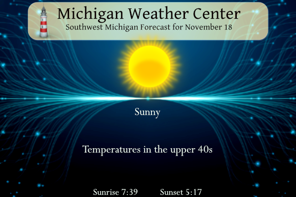
- CLEAR THROUGH SUNDAY
IR LOOP SHOWS CLEAR SKIES FROM MICHIGAN WEST ACROSS THE PLAINS.
HIGH PRESSURE OVER HE MISSOURI VALLEY IS NOSING INTO THE
STATE. CONCURRENTLY, LOW PRESSURE IS MOVING ACROSS ONTARIO TOWARD
JAMES BAY. THE RESULTING INCREASE IN THE PRESSURE GRADIENT WILL
RESULT IN GUSTY WINDS TODAY. OF COURSE, GOOD VERTICAL MIXING FROM
SUNNY CONDITIONS WILL ALSO HELP. ONCE THE SUN SETS, THE WINDS WILL
DECREASE.
CLEAR SKIES ARE EXPECTED TONIGHT AND SUNDAY AS THE RIDGE AXIS
MOVES OVER THE STATE. HIGHS TODAY AND SUNDAY WILL BE IN THE 45-50
RANGE, WHICH IS NORMAL.
LONG TERM
(SUNDAY NIGHT THROUGH FRIDAY)
ISSUED AT 300 AM EST SAT NOV 18 2023
- STORM SYSTEM TUESDAY TO BRING MAINLY RAIN TO THE AREA
MODELS FEATURE QUITE A BIT OF SPREAD WITH THIS SYSTEM IN TERMS OF
TRACK AND INTENSITY. OVERALL THE THERMAL PROFILES ARE TRENDING
WARMER, WHICH LOWERS THE SNOW POTENTIAL. ONE WINDOW FOR POSSIBLE
MIXED PRECIPITATION WILL BE AT THE ONSET LATER MONDAY NIGHT.
INTERIOR LOWER MI MAY SEE LOW LEVEL TEMPERATURES COLD ENOUGH FOR
MIXED PRECIPITATION. LOW LEVEL FLOW WILL BE FROM THE EAST WHICH
WILL ACT TO KEEP THE SURFACE TEMPERATURES NEAR FREEZING TO START
THE DAY TUESDAY. IMPACTS IF ANY WOULD BE BRIEF IT APPEARS AND
ENSEMBLE FORECASTS SUGGEST THE IMPACT RISK IS LOW AT THIS TIME.
THEN AS THE SYSTEM MOVES AWAY TUESDAY INTO TUESDAY NIGHT AND COLDER
AIR ADVECTS IN, THERE IS ANOTHER WINDOW FOR POSSIBLE IMPACTS AS THE
PRECIPITATION TRIES TO CHANGE TO SNOW BEFORE ENDING. AGAIN THE
POTENTIAL FOR IMPACTS IS LOWER THAN WHAT IT LOOKED LIKE YESTERDAY.
LOTS OF SPREAD IN SNOWFALL AMOUNTS EXISTS IN THE ENSEMBLE FORECASTS,
BUT OVERALL THE MEAN VALUES ARE AN INCH OR LESS. SURFACE
TEMPERATURES FALL BELOW FREEZING TUESDAY NIGHT INTO WEDNESDAY
MORNING. THAT, ALONG WITH SOME LAKE EFFECT SNOW SHOWERS AROUND MAY
SUPPORT A FEW SLICK SPOTS ON THE ROADWAYS. IF THE MODEL TRENDS
CONTINUE, THE LAKE EFFECT RISK BEHIND THE DEPARTING STORM WOULD
ALSO DIMINISH.
- STILL LOOKING COLD AND RELATIVELY QUIET THURSDAY AND FRIDAY
IN GENERAL THE MODELS SHOW COLDER AIR SINKING DOWN FROM THE NORTH
DURING THIS PERIOD. A HIGH PRESSURE RIDGE IS ALSO SHOWN TO BUILD IN
WHICH WILL LEAD TO SUBSIDENCE AND LOWER INVERSION HEIGHTS. GIVEN
THIS SETUP WE WILL KEEP THE THE LAKE EFFECT SNOW RISK TO A MINIMUM.
ENSEMBLE SURFACE TEMPERATURE TRENDS ARE HIGHER AND WE WILL FEATURE
THAT IN OUR FORECASTS AS WELL. ENSEMBLE SNOWFALL SPREADS ARE THE
HIGHEST FOR LUDINGTON WHICH MAKES SENSE GIVEN THE NORTHERLY FLOW.
Get ready for an extended stretch of below normal temps! Wow, just wow, WOW!
Gorgeous day. 50 and nothing but sun. Seems like everyone is putting up their Christmas lights today.
Wow, low temps in the lower 20’s! Winter is knocking on the door! Get ready! Rock n roll will never die!!
Thanks Slim. A very mild, sunny, and snowless November so far. Any stats on the amount/hours of sunshine compared to average so far? Seems November is usually pretty dark and cloudy.
I would think that we are above average for sunshine for November. Sunshine and dew points are a couple of stats that are not well kept. You know El Nino’s are known for warmer temperatures and dry conditions in our area and that is just what we have had this November.
Slim