 As we close out the year you may be interested in posting data to the CoCoRaHS community for next year. CoCoRaHS is an acronym for the Community Collaborative Rain, Hail and Snow Network. CoCoRaHS is a unique, non-profit, community-based network of volunteers of all ages and backgrounds working together to measure and map precipitation (rain, hail and snow). By using low-cost measurement tools, stressing training and education, and utilizing an interactive Website, our aim is to provide the highest quality data for natural resources, education and research applications.
Slim and I both post our data to this site for rain and snow for the whole year. My station number is MI-AN-27. To post precipitation amounts you have to have the ‘approved’ gauge which can be purchased from Weather for You.
The next step is to apply to become a CoCoRaHS observer.
CoCoRaHS is used by a wide variety of organizations and individuals. The National Weather Service, other meteorologists, hydrologists, emergency managers, city utilities (water supply, water conservation, stormwater), insurance adjusters, USDA, engineers, mosquito control, ranchers and farmers, outdoor & recreation interests, teachers, students, and neighbors in the community are just some examples of those who visit our Web site and use our data.
Some will ask why digital readings are not accepted from home weather stations. From my experience, digital readings vary from station to station I have had (and have) compared to the analog readings from the rain gauge. Plus they want everyone to use the same gauge.
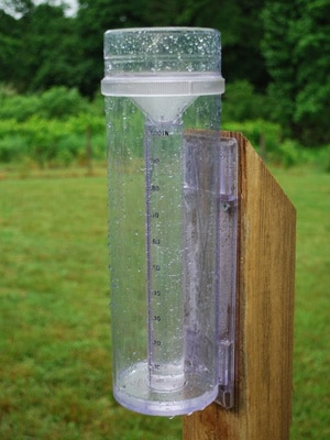
| When installing the rain gauge it is important to consider its location. The gauge should be placed in an area that is protected from strong winds but is not bothered by obstacles that could either block precipitation from reaching the gauge or cause precipitation to splash towards it. For example, an ideal location would be a small open meadow surrounded by forest, or an open back yard not too close to buildings or trees.
The gauge should be installed 2-5 feet above the ground mounted on the side of a single post. The top of the rain gauge should extend several inches above the top of the mounting post. The mounting post should have a rounded, pointed, or slanted top to avoid upward splash towards the rain gauge. Click here to view some ideas for alternatives to digging a hole. |
 |
The rain gauge should be installed at a reasonable distance away from obstacles such as buildings and trees. For example, if a tree is 40ft. tall (taller than a two story house) the gauge should be placed at least 80ft. downwind from it. This will help avoid potential blockage of the rain gauge. It is not always possible to find a perfect location. When in doubt, do your best.
Things to Remember: When mounting a rain gauge.
- Avoid large obstacles that could block precipitation.
- Avoid mounting the rain gauge where sprinklers or other sources of artificial precipitation can affect the data.
- Make sure the top of the rain gauge is level.
- Mount the rain gauge so that heavy rain could not splash into the gauge from any nearby surfaces.
- Mount the rain gauge in an area protected from strong wind, if possible.
Measuring Snow
Equipment
-
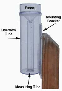
The 4″ diameter rain gauges that we use for CoCo RaHS can be used for measuring the water content of snow. However, you must remove the inner measuring cylinder and funnel for measurements of snow water content and other freezing/frozen precip. The inner tube can easily crack and break if moisture collects and then freezes. But keep the funnel and measurement tube handy indoors —you’ll need it.
-
Have a ruler or yardstick ready (ideally one that measures in inches & tenths).
-
You should have a snow board (a flat board, painted white, ideally about 16″ x 16″). They come in very handy for measuring snowfall. If not, that’s OK, but you will need to identify a good representative location that is as flat and level as possible where snow accumulates uniformly and does not melt prematurely. Wooden decks are OK, but they should be at least 20-30 feet away from your house since your house will affect snow accumulation patterns.
- You may need to have warm water handy.
Measuring Precipitation—The Water Content of Snow
The snow (rain, freezing rain, etc. too) will collect in the 4″ diameter outer cylinder (overflow cylinder). If snow collects on the rim of the gauge you have to decide what belongs in or out of the gauge. I just take a book, snow swatter, or flat object and push gently straight down on the top of the gauge. Whatever falls in is in, and whatever falls out is out. It may not be perfect, but at least it’s objective. With wet snows, a lot of snow can collect on the rim, so it makes a difference.
Bring the gauge inside at your time of observation. If it has stopped snowing, you can bring it in earlier and just let the snow melt. But you may need to hasten the process. In order to measure the water content of snow with this type of gauge, you will need to melt the contents and pour them back into the calibrated inner cylinder.
What I do is take my inner calibrated cylinder and pour warm water into it and jot down the amount. Then I add that warm water to the outer cylinder so that all the snow melts. Then I pour the water back into the inner tube and record the total amount. For example, lets say I added 0.51″ of warm water to the snow. Then when I measured the total sample, it read 0.82″ How much precipitation did I get? The answer should be 0.31″
0.82″ – Total of melted snow with the added warm water
-0.51″ – Total warm water added to melt snow
—————————————————
0.31″ – Daily Precipitation
(the amount you should report)
I hope that makes sense. Make sure you avoid spilling. It can happen.
Some people have come up with creative ways to melt their snow in their microwave or by setting their gauge in a basin of warm water. That way they don’t have to add and subtract additional water. Microwaving rain gauge samples is not recommended, but a careful person can do it successfully, or so I’ve been told. I’ve never tried it.
When you’re done, put the outer cylinder back outside, clean and dry, so it’s ready to collect the next snow (During heavy snow (6″ or greater) the cylinder will fill to the top and overflow with snow. You will have to measure more often than once daily under heavy snow conditions.
Measuring Snowfall—New Snow Amount
Snowfall is the maximum accumulation of fresh snow during the past day prior to melting or settling. We measure snowfall to the nearest 0.1 (one-tenth) inch. Maybe you have a ruler in tenths like me, but many don’t. Since snow melts and settles, you may have to measure during or soon after snow ends in order to capture how much accumulated. By 7 AM their may be less.
For example if the snow begins to fall in mid morning, accumulates to 4.2″ by 3 PM and then stops and begins melting and settling such that by 7 AM the next morning you only have 2.6″ of snow on your snowboard, then the correct number to report for your 24-hour snowfall (new snow amount) is 4.2″ — the accumulation prior to melting and settling. If the ground was bare prior to this snow your snowdepth (total depth of snow on the ground) would be rounded to the nearest half inch and would be reported as 2.5 inches.
The trick in measuring snow consistently is simply finding a good place to measure and a firm surface (such as a snow board) for your ruler to set on. Some people use low picnic tables, some use their car. I don’t recommend sidewalks since they tend to accelerate melting. Grass is where snow accumulates first, and it is OK to measure on grassy surfaces, but please know that the snow tends to sit up on top of the blades of grass, sometimes by one to three inches. Your ruler, on the other hand, will go right down through the snow and grass to the ground and give you an exaggerated reading. Just be careful to measure to the bottom of the snow not to the ground.
Measuring new snow accumulation is easy when the snow falls without wind and isn’t melting on the ground. But when the wind blows, measuring snow becomes a real challenge. We deal with drifted snow by simply taking many measurements from a variety of locations and averaging them to get a representative measure. You will get the hang of this — with experience.
If you use a snowboard, take a core sample and then be sure to clear the board after your measurement and set it in a nearby location level on the surface of the new snow. If you leave it down in a depression, it will tend to collect more snow from drifting if the snow continues.
If you witnessed snow (even just one flake), but there is not enough to measure, please report a “T” for Trace.
Snow Depth—Total Depth of Snow on the Ground
Snow depth is simply the total depth of snow on ground at your scheduled observation time (hopefully 7 AM or close). Snowdepth is measured to the nearest half inch. It includes both new and old snow, and should be reported even on days when no new snow has fallen. If necessary, take an average of several measurements. For example, if half the ground has 2″ of old snow and the other half of the ground is already bare, the average snowdepth would be 1″. If the ground has .5 inches of snow (or less) and half (or more) of the ground is bare, the average snowdepth would be reported as a “T” for Trace.
Snow Cores—Core Precipitation
Under some circumstances (primarily strong winds), your 4″ diameter gauge will not catch all of the snow that has fallen. You can watch windblown snow crystals curve around a rain gauge like water going around a rock in a river. If you believe your gauge has not adequately caught the precipitation that has fallen (or, if you’re just curious), then take a core sample of the fresh snow that has fallen. After first measuring the water content in the gauge, then take the 4″ outer cylinder and “cut a biscuit” in the fresh snow by pushing it straight down. It is best to do this on your snowboard (after you’ve measured the snow depth, but before you have cleared the snow and put it back on the surface). Use a thin sturdy cookie sheet or something like that to slide under the cylinder so that you can lift it up without spilling the contents. Be sure to measure in a representative location — not in a drift or in a wind-blown or melted area. Then proceed to melt and measure the water content like you would with any other measurement.
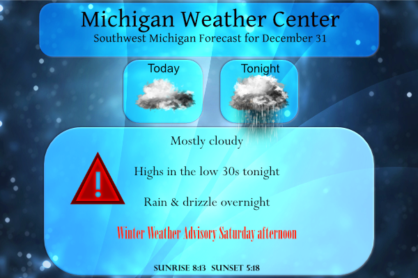
Look for cloudy conditions today, with temperatures climbing above freezing area wide. For tonight, all areas will see a chance of light rain and drizzle. Light snow and freezing drizzle are also possible from Holland to Lansing and northward. Within this area, a few slick spots are possible overnight, but travel impacts are expected to be minimal until steady snow arrives tomorrow in southern Lower Michigan.
Yesterday’s high was 33° the low 27°
Forecast Discussion updated 3:30 pm
- Travel impacts expected for Saturday afternoon into the Saturday
night

Overall models trends continue to support accumulating snow moving
into the CWA Saturday afternoon and then persisting into Saturday
night.  At the same time...the surface temperatures will be dropping
through the 20s while the winds increase out of the northeast.  As a
result...travel impacts are looking widespread..  We will be
hoisting winter weather advisories for much of the CWA. The
northern zones will see the least amount of snow generally an
inch or less so no headline up there...from Harrison to Ludington.
Further south though headlines will be warranted. There will be
two splits to the headline with some timing and amount
differences. We have a swath of 4 to 6 inches of snow from near
South Haven to Lansing with gradually lesser amounts further north
and south of this axis of higher snow amounts.

The right entrance region to a strengthening upper level jet sets up
over the low level baroclinic zone located over central and southern
parts of the CWA Saturday afternoon and evening. Mid level fgen
is noted as well especially Saturday evening. This is when the
column...including the DGZ is most saturated and the lift is
maximized. As a result...accumulating snow is expected and it
could be moderate at times. Currently the southern half of the CWA
is projected to see the most snow. Several models like the High
Res Euro...UKMET and Canadian models have trended downward with
the amounts over the past few runs so there is still some
uncertainty as far as how much snow we actually see. However from
an impact perspective combining the snow...wind...falling
temperatures...the travel should end up being treacherous even if
we only see a few inches of snow.


- Risk for dense fog tonight and local freezing drizzle

Last night there was widespread fog upstream across portions of
IA into MO. We will continue to advect a moist low level airmass
into southern MI this evening. Also there have been some pockets
of clearing this afternoon. As we go through the evening...fog
should develop across Southern Lower MI. Models like the HRRR are
showing the fog becoming dense. While this could
happen...increasing winds may limit this potential. For now we
will feature areas of fog in the grids and zones.

Light precipitation will be possible overnight as a
weak wave of low pressure tracks northeastward along a frontal zone
over Lower MI. There is some lift up to about 4k ft shown in the
moist layer especially over northern zones. Some of this
precipitation could be a mix of freezing drizzle or light snow to
the north of a Big Rapids to Mt Pleasant line as surface
temperatures will be near or just below freezing. Basically we
will feature high POP`s but low QPF for this weak system. Local
travel impacts are possible where the freezing drizzle and light
snow occur.
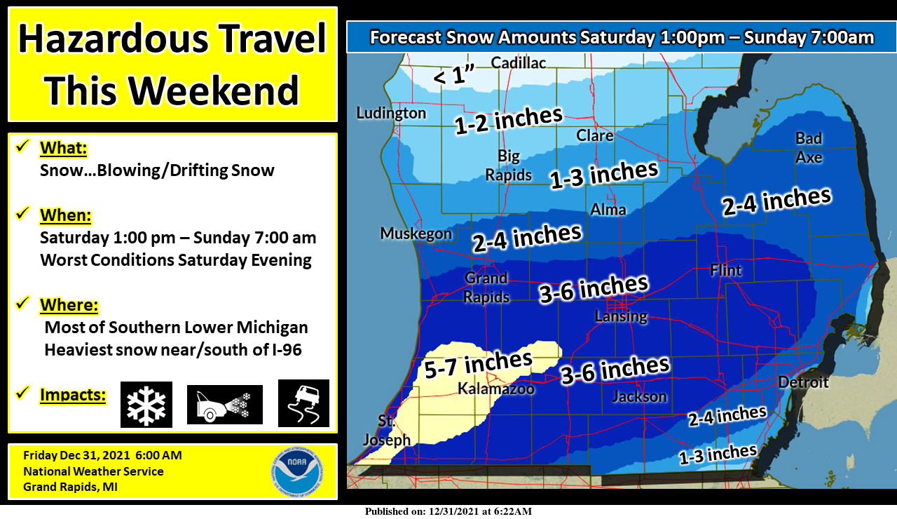
Widespread accumulating snow is expected this weekend from Saturday afternoon through Sunday morning. The heaviest snow will fall near and south of Interstate 96. The highest totals will likely be found in the southwest corner of the state. Blowing and drifting snow is likely Saturday night with a northeast wind of 15 to 25 mph. Hazardous travel is expected, especially Saturday evening. If traveling Saturday afternoon through Saturday night be prepared to encounter limited visibility and snow-covered and slippery roads.
AccuLESS weather is out to lunch as usual. They have GR in the band of 6 to 12 inches. Ya right!
https://www.accuweather.com/en/winter-weather/snowstorm-forecast-chicago-detroit-denver-new-year/1116665
A snowy and colder pattern has begun..Woo woo InDY
I just checked the latest RBD model and as boring as it may be, it totally agrees with the NWS! Grand Rapids looks like 3 to 5 inches max! At any rate a solid WWA and then cold and snow the following week! Winter in West MI – nothing better!
Updated Forecast Discussion – Advisories are below
Ottawa-Kent-Ionia-Clinton-Allegan-Barry-Eaton-Ingham-Van Buren-
Kalamazoo-Calhoun-Jackson-
…WINTER WEATHER ADVISORY IN EFFECT FROM 1 PM SATURDAY TO 7 AM
EST SUNDAY…
* WHAT…Snow expected. Total snow accumulations of 3 to 6
inches.
* WHERE…Portions of south central and southwest Michigan.
* WHEN…From 1 PM Saturday to 7 AM EST Sunday.
Oceana-Newaygo-Mecosta-Isabella-Muskegon-Montcalm-Gratiot-
…WINTER WEATHER ADVISORY IN EFFECT FROM 4 PM SATURDAY TO 7 AM
EST SUNDAY…
* WHAT…Snow expected. Total snow accumulations of 2 to 4
inches.
* WHERE…Portions of central and west central Michigan.
* WHEN…From 4 PM Saturday to 7 AM EST Sunday.
1. It was a very warm December with much below average snowfall 2. It was a warm 2021 – fourth warm year in a row I believe 3. Even after this weekend’s snow, GR will still be in a snow deficit for the season
GO BLUE!
For the year 2021 will be the 8th warmest on record here at Grand Rapids it will be the warmest year since 2016. Of the top 10 warmest years 5 have been since 2010. With 2012, 2016, 2010, 2021 and 2017.
Slim
But almost a week straight now with snow pack on the ground makes up for the snow deficit in a lot of ways …Let it snow let it let snow ….InDY
Check out the latest NAM!
HAZARDOUS WEATHER OUTLOOK
Snow will begin Saturday afternoon (New Years Day) and continue
into Sunday morning. The heaviest snow will fall Saturday
evening. Widespread accumulating snow is expected with the
heaviest amounts occurring along and south of the Interstate 96
corridor. The heaviest swath, where 4 to 7 inches may fall, should
set up from South Haven east to Lansing and Jackson. Hazardous
travel will develop from Saturday afternoon and continue into
Saturday night. Blowing and drifting snow is expected as well with
northerly winds of 15 to 25 mph.
Updated post to reflect NWS graphics and snow guesses for tomorrow…
It appears I am in the sweet spot for snow – Bittersweet will be happy.
It was yet another mild overnight here as the low of 32 with cloudy skies the current temperature is 35. There is still 1.5″ of snow on the ground. This December will end up being the one of the warmest on record here in Grand Rapids. With a current mean of 34.5° The warmest December on record is 39.1 set in 2015. 36.2 in 1923 is in 2nd place then 35.8 in 1931, 35.1 in 2012, 2006, 2013. 35.0 in 2011. Then this year note that 5 of the current warmest Decembers have happened in the last 20 years.
Slim
What was last years mean?
Sorry for the late response but last year the mean for GR was 32.4.
Slim
Thanks! I didn’t think this year was that much warmer than last December but looks like it was by quite a bit.
Thanks MV for the great post today a lot of great information. My CoCoRahs number is KN-33
Slim
Happy New Years Eve! It looks like next week is trending colder… this might be the start of a much colder/snowier pattern 😀
Exactly! Get ready!
Happy New Year’s everybody!! Have a safe and healthy one.
Facts! We have had 100% more snowfall this December vs last December, so nothing like last year! Get ready for a wild January!
True, this December I believe had more high temp records than last year.
This December was warmer than last year.
Slim
I’ve always wanted to get into the reporting of weather conditions and totals, but now running my business I’m just way to busy to get around to it working 60 – 70 hours every week.
As for December, wow! This is 2 years in a row now with zero snow blowing and zero plowing of our parking lot. Talking with the previous owner who kept a log of every time plowed for 32 years, there was never even 1 December that he didn’t need to have the lot plowed.
His memory is mistaken and 100% wrong!
Nope. I have the log right here in the office. I can screen shot all the pages for you if you want.
Don’t bother, however if he plowed last December it was for about a 2 inch snowfall event and we have had at least three of those type of events already along with 5 WWA’s! Keep the snow coming!
He didn’t have the lot plowed last year because last year I owned the business. Zero plows last December, zero plows this December. First time in 34 years.
Get ready to Rock! Our snowstorm is still on track! I love how people on here say a 3 to 6 inches snow event is not that big! Get real! A solid advisory level storm is on the way with moderate to heavy snowfall, wind and cold! Winter at its best baby! Stay tuned for the RDB official snowfall prediction! We are transitioning to a long stretch of wild winter weather! Rock n roll will never die! I love it!
Lot of good info, as always. Thanks MV.
Speaking of lots of info, the morning AFD above is an interesting read. It provides some insight as to their logic and decision-making process.
Snowblower is primed and ready for Sunday. Happy New Year!🎊🎈🎆