We had a few raindrops fall here in Otsego yesterday morning, not enough to assume even a trace while from Grand Rapids to the north taunted us with their rain and storms. The thunderstorm watch for Allegan and Barry counties were not productive and lay our hopes for rain dashed by the wayside. We will see similar circumstances today.
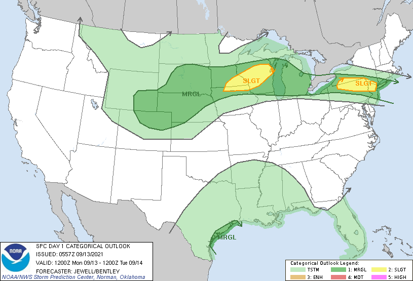
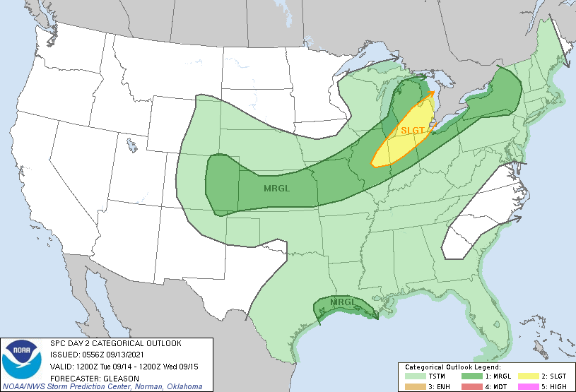
Additional rounds of thunderstorms will affect portions of Lower Michigan through Tuesday. Most of these storms will NOT be severe. However, there is a small risk of severe thunderstorms today/tomorrow for communities within the dark-green shading. A somewhat greater risk of severe storms exists on Tuesday for communities within the yellow shading. Here are some key messages: (1) For today and tonight, the timing of storms is uncertain. We expect that several rounds of storms will affect parts of Lower Michigan at different times, but details are unclear at present. (2) For Tuesday, the main risk of severe thunderstorms (yellow shading) appears to be focused in the afternoon/evening. (3) On both days, the main risks will be for local wind damage to trees and power lines, along with large hail and locally heavy rain. Note, however, that most locations will NOT experience severe weather.
Below are the SPC graphics for today and tomorrow.
[columns] [span6]
[/span6][span6]
[/span6][/columns]
Forecast Discussion
- Periods of convection into this evening

A stalled front to the south of Michigan (near I-80) is parallel
to the upper jet, which will be over northern WI into the northern
half of Lower Michigan through the day today. One shortwave is
causing thunderstorms, some strong over southern WI at 3 am this
morning. That convection will reach the I-96 area before sunrise
and will likely weaken some as it does so. The next upstream
shortwave will kick of another area of storms that will track
across the area this afternoon into early this evening.

The deep layer bulk shear is in the 30 to 40 knot range where the
storms will track. There is an elevated mixed layer between 950
and 850 mb so the instability is above 850 mb. Even so there is
around 1500 j/kg of cape for the storms so I would expect the
potential for some large hail from these storms. Gusty winds are
possible for the stronger storms but it may be hard to mix the
wind through that frontal inversion.


- Warm front/cold front brings strong storms to area Tuesday

Tuesday will be the most active weather day of the week. We have
the both and northern and southern stream shortwave trying to come
in phase with each other over the central CONUS. This leads to a
deepening surface over WI early on Tuesday that tracks north of
Lake Superior during the day. This pushes a warm front north
through the CWA during the morning then the trailing cold front
comes through in the mid to late afternoon hours.

The conditons look favorable for strong to severe storms, more so
east of Grand Rapids then from GRR to the lake shore. The southern
and northern stream jets merge over Michigan by late in the day on
Tuesday. That creates a strong right entrance region lift area
that comes over Southern Michigan in the afternoon. As with the
previous event, we have 40 to 50 knots of deep layer shear, 7 to
8c lapse rates in the 700 to 500 mb layer (good for large hail),
and unidirectional shear. All of the HI-RES models (as viewed in
HREF) show decent helicity tracks just east of GRR in the
afternoon. The storms should be out of the area by early evening.

It will be a breezy and warm day too with winds gusting of 20 to
30 mph inland during the afternoon. Highs should be mid to upper
80s south and east of GRR.

- Quiet weather mid week then turning warmer by the weekend

Once the front is through by late afternoon Tuesday surface
high pressure and upper ridging build into the area. This front
will bring cooler air into the area for Wed and Thursday.

Later in the week a much stronger Pacific system moves on shore
and that builds a large upper ridge in front of it. That means
warming late in the week into the weekend. Highs could be
approaching 90 by Sunday into Monday. There could be some
thunderstorms with the warm front Friday or Friday night but it
seems most of that will really be farther north than our area.
No grass cutting today …INDY..
I am glad everyone was ready for the rain storm! There will be more coming over the next 36 hours! Get prepared now!
That was a nice storm. High winds, lots of rain. I’m willing to be that we’ve had more severe thunderstorm warnings this summer than the last three summers combined.
Yep…it became seriously dark…street lights popped on. ADA received 4/10 of an inch. Appreciated.
Hey we finally got some rain! 1.18” by us. Grass already looks greener. Now we can keep mowing till December.
It poured here too. Also got some hail. I can see the grass growing already.
It is dark as night here.
Darkness is moving in quickly from the west.
T storm here. Hail bouncing off my windows.
its pouring over here
Get ready now!
It is great to see some above normal temps as we head into Fall! That will keep the lakes warmer than normal and then when winter hits we will get pounded with lake effect SNOW! Winter will be here before you know and the rock n roll party will get into full gear! Who wouldn’t love winter in MI? Incredible!
Well that’s the exact same thing you’ve said the past couple of years, yet the past couple years it hasn’t really snowed until late January or early February. In fact, Slim might have to verify this, but I believe last year was something like the latest we’ve ever had snow, or maybe it was the least amount of snow ever by mid January.
This year we will have a weak La Niña which equals massive cold and snow! Facts are facts so get ready to rock!
And that is pretty much exactly the same pattern that we had last year. Just think, if we repeat the past several years pattern, there won’t be snow on the ground for another 4 months yet!
Not a drop of rain here yesterday.
Well its been over 3 weeks on cutting my grass today maybe the day the slowing down grass growing season is here woo woo lots of dead leafs fallen to haft to get the rakes out love Fall dose it get any better then this ?? INDY
In a very heavy shower yesterday I recorded 0.34″ of rain. But at the airport they only had 0.06″ of rain fall. This morning just the opposite. GRR reported 0.08″ and here at my house just 0.01″ The overnight low was 61 both here and at GRR. At this time it is cloudy with a light mist and 62 here.
Slim
Loving all the 80+ degree days in September. Approaching 90 degrees this weekend? Summer just won’t quit!
Hey, it’s raining here! We got zip, zilch, zero yesterday.