
Yesterday we had a brief period of sunshine which lasted maybe half an hour. Even with all the clouds we still had no rain in Otsego. It has been 18 days since we had more than a tenth of an inch of rain.
Yesterday’s high was 77° and the low was 64°. Sunrise today is 7:22, sunset is 7:54 pm.
Today will be the best chance for widespread rain across the southern lower peninsula then we begin another long dry spell with temps rising well into the 80s.
Severe storms will be possible late this afternoon through the early evening. These may not affect all of West Michigan though, as they will likely develop east of US 131 and move southeast. The risk to see severe storms is higher south and east of a line from St. Joseph to Ionia to Saginaw. The main risk from severe storms will be wind damage to trees and power lines, but we may also see large hail. An isolated tornado is not out of the question. The heavy downpours during rush hour could increase the chance for hydroplaning and localized flooding.
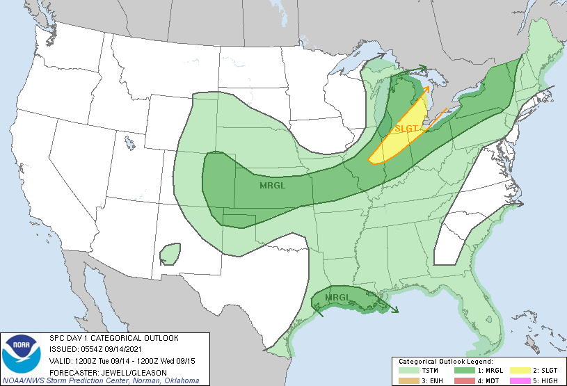
Convective Outlook from the SPC
   A shortwave trough will move across the upper Great Lakes today,
   with a surface low moving from Upper MI into Ontario. A cold front
   will trail south from the low, oriented roughly from southeast Lower
   MI into eastern IL by 00Z.  Ahead of the front, mid to upper 60s F
   dewpoints will be common, along with good heating resulting in 2000+
   J/kg MUCAPE by late afternoon.

   Deep-layer shear will be most favorable over northern parts of MI,
   with up to 60 kt into Upper MI. However, instability will be
   greatest farther south where shear will be less. Isolated strong
   storms will be possible early in the day, but the greatest threat
   will be with storms along the front after 21Z from central Lower MI
   into IL. Linear forcing along the front suggest wind may be the
   primary concern, but hail will also be possible.
Forecast Discussion
- Storms late afternoon with cold front

Not much change from our previous thinking today. It still looks
like strong to severe storms are likely east of GRR late this
afternoon into this evening.

This is actually a somewhat complex situation. What sets off the
storms is a southern stream shortwave, currently over Iowa. It is
when that shortwave moves over the front after 2 pm that the
storms really develop. Until then we have surface convergence with
little upper divergence. However, when that shortwave comes over
the front after 2 pm the upper divergence increases dramatically.

As for the severe weather event itself, the presence of steep
level lapse rates continues evidenced by the hail reports seen the
last 2 days. More than 30 knots of deep layer shear across our
CWA will help organize the storms. Though the strongest shear is
further north.

We have moist air below 600 mb (RH above 70 pct) with a dry layer
from 600 mb to 500 mb (RH <10 pct). There is another moist layer
above that. This all results in Dcape over 1000 j/kg. The EL is
near the trop (good for severe storms), precipitable water is
around 1.7", a good indicator for the potential for heavy rain.

Along with the above is the presence of fat cape in the -10 to
-30c range of the forecast sounding. The SARS sounding analogs
 shows nearly a dozen cases of hail greater than 1 inch for this
 sort of sounding.

While tornados will remain an outside threat, 0-1km SRH will be
strongest through SE MI during the early evening hours.

So it would seem straight line winds, large hail and locally
heavy rainfall would be the most likely hazards for this event.
Storms will be racing east around 40 knots so I do not see a
threat of more than localized flooding.

Once the front comes through the skies should become at least
partly cloudy and temperatures will turn cooler along with dew
points falling into the 50s. However, temperatures will remain
above normal into Wednesday morning.

- Quiet weather Wednesday into Thursday

For Wednesday into Thursday, we are actually south of the primary
polar jet with the system coming through today. The jet approaches
the region Wednesday morning but it quickly lifts out as the next
Pacific system tracks along in the upper level flow. That system
will track east north of the Canadian boarder. We will have
surface high pressure and upper level ridging over the state
Thursday. This will result in considerable sunshine during the
day with light winds and warmer afternoon temperatures.

- Next front stalls near us early in weekend

That second system that tracks east over central Canada during the
mid week period trails a cold front into our area Friday. This
front looks to stall over central lower Michigan Saturday before
lifting north as a warm front Sunday. This of course could mean
more scattered showers and thunderstorms. Unlike the systems we`ve
had over the last few days Friday`s front lacks mid level
moisture and dynamic forcing The result will be some showers but
little threat of strong to severe storms. Any storms should be
weak and isolated. Most of the precipitation, what little there
would be, will likely be north of I-96.

- Surge of very warm temperatures Sunday into Tuesday

Currently there is a fairly strong system over the western Pacific
just east of Japan. That system will reach the west coast of the
United States this coming weekend. It is expected to dig a large
upper trough over the western North America as far south as
Nevada. That will build another one of those large eastern upper
ridges. It still looks like we will be in just sweet spot for hot
temperatures Sunday into Tuesday. Even the ensembles of the GFS
give us highs in the mid to upper 80s Sunday into Tuesday. The
ECMWF ensembles give us highs in the mid 80s. By then our normal
highs are in the lower 70s and lows are normally around 50. We
could be running 10 to 15 degrees above normal for 3 or 4 days if
this really happens.
Temp is down to 76* degrees out in my hood cold front is through dry …Feels great outside…INDY..
SEVERE THUNDERSTORM WATCH 498 IS IN EFFECT UNTIL 1100 PM EDT FOR THE FOLLOWING LOCATIONS ALCONA ALLEGAN ARENAC BARRY BAY BERRIEN BRANCH CALHOUN CASS CLINTON EATON GENESEE GLADWIN GRATIOT HILLSDALE HURON INGHAM IONIA IOSCO ISABELLA JACKSON KALAMAZOO KENT LAPEER LENAWEE LIVINGSTON MACOMB MIDLAND MONROE MONTCALM OAKLAND OGEMAW OTTAWA SAGINAW SANILAC SHIAWASSEE ST. CLAIR ST. JOSEPH TUSCOLA VAN BUREN WASHTENAW WAYNE
All action to the East. Once again…not our weather.
Right now it is sunny and has a little breeze, very nice day out😀
Boy, what happened to the talk of cool “Fall” weather and September frost? Dew points are once again up around 70 and temps approaching 90 again next week. The Summer that won’t quit.
The trend of warmer Autumns seems to be continuing. Last time we had a cool fall was back in 2015 (I think, I might be off by a year) when we had a frigid November.
We are in the level 1 risk, so I doubt we will get anything, but I could be wrong.🤔
Wow, look at that 8-day forecast. Are we in July or mid September?
In the last 10 years warm Septembers have been common. In that time 2019, 2018, 2017,2016 and 2015 have all been in the top 15 warmest Septembers at Grand Rapids.
Slim
That is very interesting.
Nice! It’s been common for every month to be warm the past 10 years it seems. I believe summer marked our 4th or 5th straight warm season in a row. And we are going for 4 or 5 warm years in a row in 2021.
I agree it needs to get colder not warmer
i agree, it needs to be colder not warmer