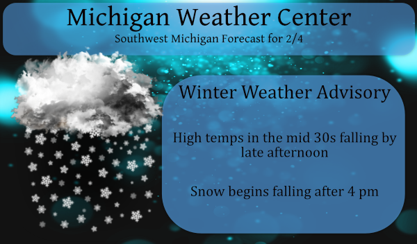
We will be under the gun of snow beginning late today. There is a winter weather advisory in place for all of Michigan and a blizzard warning for the U.P… Snow will arrive late this afternoon, creating slick roads and low visibility. Conditions will worsen by Friday morning, as gusty winds, blowing/drifting snow, and quickly falling temperatures are added to the mix. Near white-out conditions are expected at times Friday, especially near/west of US 131. Very cold temperatures will last into late next week, with occasional snow.
I will call this one the Groundhogs Revenge due to his anger at being hauled from his warm hole on a cold day for the entertainment of us humans. Looking at some models we could see up to 10 inches of the white stuff in some areas by tomorrow evening as lake effect kicks in behind the synoptic event. You can find your local forecast and radar on the main page.
Below is the explanation I promised yesterday on how lake effect snow is predicted:
1. Background
Starting the winter of 2008-2009 the National Weather Service in Gaylord will begin using a new tool to assist with lake effect snow forecasting. This tool, referred to as the Lake Snow Parameter (LSP), is designed to help forecasters more accurately anticipate the location, timing, and intensity of lake snows around the Great Lakes. The LSP is a quantitative measure of the likelihood of high snowfall rates, and is based on data collected during a four year research project conducted by the National Weather Service in Gaylord.
2. Motivation for Developing the Lake Snow Parameter
Forecasting lake effect snow is extremely challenging. There are many reasons for this, among them is the fact that 1) snow accumulations are often very localized, and 2) many complex factors must be considered when forecasting lake effect snow. Several of the factors that must be accurately assessed include: air temperature, water temperature, air-water temperature difference (or Delta-T), instability, instability depth (or inversion height), snow microphysics, upstream moisture, large-scale lift, wind direction, wind speed, fetch length, inland elevation changes, and shoreline orientation.
Assessing the relative importance of these factors on lake snow production is often very difficult, especially when the various factors change in space and time. For example, large-scale lift and moisture may be ideal for lake snow today, while the best snow microphysics may not arrive until tonight. This may result in only a brief three to six hour window when both of these favorable conditions overlap. This forecast challenge (very typical during lake snow events) was the basic motivation for developing the Lake Snow Parameter. In other words, the goal was to develop an operational parameter that accounted for multiple meteorological factors simultaneously and increased when the probability of higher snowfall rates increased.
3. Calculation of the Lake Snow Parameter
A four year research project conducted by the National Weather Service in Gaylord isolated three factors very critical for lake snow production in northern Michigan. Though all of the meteorological factors listed above are important (and must be considered) the three factors found to be particularly critical included 1) 850 mb temperature, 2) 850-700 mb mean relative humidity, and 3) 1000-850 mb wind speed.
Based on local research, 850 mb temperatures between roughly -12°C and -19°C tended to promote heavier snowfall. This is not surprising, since 850 mb is located near the middle of the snow production layer for many lake snow events, and this temperature range (coupled with sufficient moisture and lift) helps to promote the development of large dendrites (snowflakes). High relative humidity in the 850-700 mb layer was also well correlated with heavy lake snow. There are two reasons for this: 1) It can indicate a higher inversion and therefore a greater convective depth for snow production (pure lake effect), or 2) It can indicate synoptic moisture above the inversion, with implied synoptic ascent and/or seeding from clouds above (lake enhancement). As boundary layer wind speed increased, local research indicated a tendency for greater snowfall. This is consistent with the known relationships between higher wind speeds and greater heat and moisture flux across an air-water interface. As a result, 1000-850 mb wind speed is the third factor considered in the LSP (of the three factors included, wind speed has the least overall impact on the LSP).
The LSP is non-dimensional, and is the product of three Weighting Functions (WF) — one WF for each of the meteorological parameters previously described.
Lake Snow Parameter (LSP) =
WF(850 mb Temp) x WF(850-700 mb RH) x WF (1000-850 mb WS (Wind Speed))
The weighting function for each of the meteorological parameters is shown below (click to enlarge).
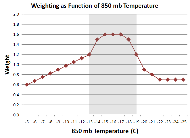
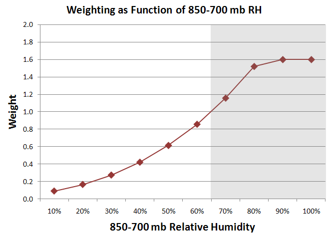
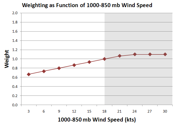
Two example LSP calculations follow. Example One: 850 mb Temperature = -16°C (excellent for large dendrites), 850-700 mb RH = 75% (high), and 1000-850 mb Wind Speed = 19 kts (moderate) would result in a Lake Snow Parameter of 2.17 (1.60 x 1.33 x 1.02). Example Two: 850 mb Temperature = -24°C (too cold for large dendrites), 850-700 mb RH = 50% (moderate), and 1000-850 mb Wind Speed = 17 kts (moderate) would result in a Lake Snow Parameter of 0.42 (0.70 x 0.61 x 0.98).
4. Operational Use and Limitations of the Lake Snow Parameter
The Lake Snow Parameter is a tool. It cannot replace a thorough examination of all meteorological factors contributing to the lake snow event!
Forecasters should not use the LSP to determine if lake snow will occur. Rather, they should look at spatial and temporal trends in the LSP, as well as the magnitude of the LSP, to help them more accurately anticipate the timing and location of higher snowfall rates associated with lake snow events. It is hoped that by using the LSP in this manner (as a situational awareness tool) forecasters will more quickly recognize when subtle meteorological changes may impact the behavior and magnitude of a lake snow event.
Preliminary experience suggests the following Lake Snow Parameter thresholds for anticipating the likelihood of high snowfall rates:
| LSP Range | Potential for High Snowfall Rates |
| Less than 1.0 | Low Potential |
| From 1.0 to 2.0 | Moderate Potential (conditional) |
| Greater than 2.0 | High Potential |
Lastly, it should be noted that since the LSP was developed over northern Lower Michigan (where multiple band lake snow events are most common) its direct application to other parts of the Great Lakes may be problematic. For example, because single band lake effect snow events have different characteristics than multiple band events, the LSP may have limitations in some areas. In addition, the LSP does not directly account for the impact of forced topographic ascent, fetch length, vertical wind shear, or kinematic vertical motion.
Forecasters may find the LSP particularly useful when viewed together with low level model omega fields. The resulting diagnostics would not be unlike the “cross hair” signature for heavy synoptic snow.
Bruce B. Smith, and John P. Boris, NWS Gaylord
New post available with storm info…
Well, well well, it is nice to see the NWS come around and agree with the RDB model! I have no idea why they did not issue a Winter Storm Watch yesterday but at least they came around eventually! Parts of Kent County are in the 12 to 18 inch range by Sunday morning and the point forecast for GR shows 10 to 12 inches by Sunday morning! Who would have thought? Absolutely INCREDIBLE!

Nice post MV, but the math makes my head want to explode. Sometimes just a gut feeling is as good as any extended math equation.
Getting some light rain now with a “thaw” temp of 37.
Looks like the WSW has been extended to the south into Kent county
Slim
Bingo Kent ottawa and Allegan has been added to the winter storm warning list ..INDY
Yes it has….
UPDATE
ISSUED AT 137 PM EST THU FEB 4 2021
THE WINTER WEATHER ADVISORY IS UPGRADED TO A WINTER STORM WARNING
FOR OTTAWA, KENT, AND ALLEGAN COUNTIES. THIS IS BASED ON THE
EASTWARD EXPANSION OF HIGHER FORECAST SNOWFALL TOTALS. STRONG
WEST-SOUTHWEST FLOW SHOULD BRING HEAVIER LAKE EFFECT SNOW SHOWERS
WELL INLAND AND TRAVEL CONDITIONS WILL BE VERY POOR IN HEAVY
FALLING AND BLOWING SNOW WITH ZERO VISIBILITY AT TIMES.
Slim
WSW upgrades to the NW. Maybe Kent this afternoon 😀
Great Scotty winter storm warning Muskegon Newaygo counties now here it comes …..GR you’re next ….Let it snow let it snow let it snow …..INDY
At the current time there are areas of moderate and heavy snow falling in parts of Iowa and Wisconsin. And while it may be overdone the latest GFS dose not have GR getting above 19 from late Friday to Wednesday the 17th. We shall see.
Slim
NWS update:
UPDATE…
Issued at 1148 AM EST Thu Feb 4 2021
The Winter Weather Advisory is upgraded to a Winter Storm Warning
for Mason, Lake, Oceana, Newaygo and Muskegon Counties. This is
based on expected near zero visibility in falling and blowing snow
tonight and Friday. Conditions will also be bad further south in
Ottawa, Kent, Allegan and Van Buren Counties, so we will see what
the trend will be with the afternoon update of the snow and wind
forecast. The warning may have to be expanded to those counties as
well.
Who knew?
This is the storm everyone has been waiting for all winter long. I hope the snow nuts enjoy because this has been the shortest winter ever! Hopefully, the snow totals hold up to expectations. We shall see.
This winter season has been very similar to the winters of 1931/32 and 1932/33. At the start of February 1933 the winter season only had 12.8″ of total snow fall (compared to this years 15.2″) In February 1933 it turned sharply colder late in the day on February 4th and in the next 7 days 20.4: of snow fell in on two days the highs were only +9 and +3.
Slim
More from the NWS on this dangerous winter storm! My advise, don’t drive tomorrow if possible, make sure your snow blower is working, get your best cold winter gear ready for use, make sure you have salt on hand, amd if you do need to drive, SLOW DOWN and don’t TAILGATE! Get prepared now!
https://www.weather.gov/grr/weatherstory
Here is the latest NAM and the latest snowfall forecast directly from the NWS! Issue a WINTER STORM WARNING and fast! What in the world are they thinking?
http://wxcaster.com/gis-snow-overlays.php?STATIONID=GRR

Winter Weather Advisory is all? The same advisory used for 1-3″ of snow?
Finally we agree on something!
It feels like the calm before the storm this morning. We prepped yesterday a bit outside. Maybe we can get in some sledding this afternoon before the cold sets in.
Interesting post. I always forget how much mathematics is used behind the scenes. We (the public) see the simplified, colored/labeled snowfall maps. But there is a lot that is used to produce these maps.
By the way, not to critique the NWS, but it seems that they have been using awfully strong wording for just a WWA. Based on the wording of their impacts, I feel that a WSW upgrsde would still seem possible. Even if the snow criteria is not met, the other impacts seem like enough to warrant one.
You got it Nathan and you are spot on! The GR NWS has been very cautious about issuing a warning lately! It is unquestionable that this should be a WINTER STORM WARNING! Their job is to alert the public and this is a potential life threatening storm and the roads and visibilities will be horrendous tomorrow! Mark it down!
Like I’ve mentioned before, we need more than just 2 types of alerts, advisories and warnings. There needs to be a way to separate a 1-3 inch event from a 6-8 inch event. 1″ vs 8″ is a big difference for an advisory!
It will be interesting to see if the dreaded west Michigan dry slot sets up. My snowblower had been pretty lonely this season 😁
No dry slot with one, just tons and cold and snow!
Good information MV
Slim
After a couple of mornings where it was much colder here than at that the airport today I am now back on the same page. The official low at GR overnight was 20 and the low here was a little warmer at 22. At this time it is partly cloudy and 25 both here and at the airport.
Slim
Excellent post, Michael. I think some people do not have the appreciation of the level of math and science that goes into meteorology.
Lake effect is one of the harder events to forecast in our area. It is very localized and while it happens often here everything has to come together just right. We shall see how this weeks event plays out.
Slim
>>>>>>Breaking Weather Alert>>>>>All of SW Lower MI should be placed in a Winter Storm Warning and fast! The RDB model gives GGR 8 to 12 inches of snow this weekend, along with wind, drifting, cold, horrendous roads, low visibilities, etc! If this isn’t a WSW you might as well never issue one!! Check out the 5 day GFS snow map! Bring it!
http://wxcaster.com/gis-gfs-snow-overlays2.php?STATIONID=GRR
Nice lake effect snowfall write up!